National Hurricane Center
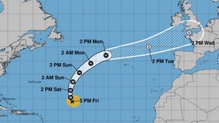
This NHC map shows the arrival of Hurricane Kirk towards Europe, which will become a depression when it crosses France on Wednesday October 9.
WEATHER – An autumn storm is approaching! Hurricane Kirk, category 4/5 on the Saffir-Simpson scale, is currently in the central Atlantic Ocean and is not expected to make landfall. However, “Kirk” will slowly approach the European coasts and bring rain and a lot of wind to France next week, writes Météo France, in its forecasts for this Sunday, October 6.
The X account from Keraunos, the French observatory of storms and tornadoes, explains that the hurricane “will pass off the coast of La Coruña in Spain before transiting the north of France”. You can see its possible trajectory on the visualization below of the Met Office, the British national meteorological service.
Reading this content may result in cookies being placed by the third-party operator who hosts it. Taking into account the choices you have expressed regarding the deposit of cookies, we have blocked the display of this content. If you wish to access it, you must accept the “Third Party Content” category of cookies by clicking on the button below.
Play Video
Of the “stormy winds » up to 100 km/h
Its effects on France should be felt by mid-week. “Becoming a post-tropical depression, this system will circulate over France between Wednesday and Thursday, bringing strong, even violent winds, and heavy rain”confirms Météo France. The meteorological service specifies that even before the arrival of this depression, “ an episode of heavy rain and thunderstorms is expected between Monday October 7 afternoon and Tuesday October 8, particularly in the South-East”.
Reading this content may result in cookies being placed by the third-party operator who hosts it. Taking into account the choices you have expressed regarding the deposit of cookies, we have blocked the display of this content. If you wish to access it, you must accept the “Third Party Content” category of cookies by clicking on the button below.
Play Video
On X, the national forecaster estimates that precipitation could reach “up to 60 mm in Brittany, Pays-de-la-Loire, Normandy”the equivalent of several weeks of rain falling in a few hours. Hurricane Kirk, which therefore became a depression on Wednesday, will also bring “stormy winds » up to 100 km/h in the Center and Vendée.
Reading this content may result in cookies being placed by the third-party operator who hosts it. Taking into account the choices you have expressed regarding the deposit of cookies, we have blocked the display of this content. If you wish to access it, you must accept the “Third Party Content” category of cookies by clicking on the button below.
Play Video
The « threshold of the storm » should be reached in France, abounds The Weather Channelo, which estimates that the intensity of the winds will depend on two factors: “the deepening of the depression (its minimum pressure) and especially the trajectory of the passage of the depression core. » If Kirk goes back to the north of the British Isles, France should be hit by less strong gusts.
Risks of “orange alerts and overflows”
Among our neighbors across the Channel, the damage could be even greater, where Kirk could “cause a strong storm over Ireland and England on Wednesday and Thursday”specifies The Weather Channel.
The effects of the depression on France are worrying, particularly for crops. Agroclimatologist Serge Zaka asks X about this: “next week will be difficult again for farmers: excess water (for the 50th time) and risk of crops dying (sunflower, corn)”he explains. And the scientist laments: “ It will not be surprising to have orange alerts and excesses, while autumn is just beginning. »
Also see on Le HuffPost :
Reading this content may result in cookies being placed by the third-party operator who hosts it. Taking into account the choices you have expressed regarding the deposit of cookies, we have blocked the display of this content. If you wish to access it, you must accept the “Third Party Content” category of cookies by clicking on the button below.
Play Video