The weather week will be disrupted in France, very disrupted. The country will find itself under the influence of two ancient tropical systems. Two what? This is a tropical storm and a hurricane that has moved up to our latitudes.
By finding themselves so high in the northern hemisphere, they lose their tropical characteristics, that is to say their most violent. But they can still pose a danger. France will first suffer the attacks of the former tropical storm Joyce, which has become a depression. Then it will be confronted with the arrival of the remains of Hurricane Kirk, which should hit it with characteristics corresponding to those of a classic autumn storm.
From the end of this weekend, the remains of storm Joyce, off the coast of Ireland, will have several consequences in France. Its size and its direction of rotation counterclockwise will cause an upwelling of air from southern Europe and northern Africa. Temperatures will therefore increase in the south-west of France. Sunday and Monday in the afternoon, it could be around 25°C, or even higher locally.
The most powerful gusts forecast for Wednesday
But Joyce will above all cause significant precipitation. They will gradually spread throughout the country on Monday. They will first take place in the North-West due to the depression. Then, due to the air mass that this depression brings up, bad weather will occur in the South. The strongest should occur between the Cévennes and the south of the Jura.
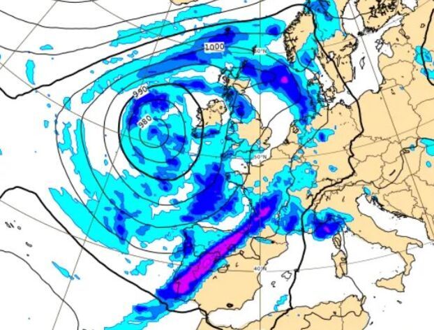
This map from the European Center for Medium-Range Weather Forecasts (ECMWF), valid for Monday at midday, allows you to visualize the situation: the center of the depression is off the coast of Ireland and is causing precipitation as far as France; the size and rotation of the old storm Joyce are, at the same time, bringing heat and humidity back up from the Iberian Peninsula.
After this first disrupted episode, the remains of Hurricane Kirk are expected to arrive from Tuesday night to Wednesday. Carried away at the start of the week by the dominant currents in the North Atlantic, it should then lose its tropical characteristics and affect the country at storm stage. Although there is no universal definition of a storm, Météo France considers that it corresponds to gusts of 120 km/h to 130 km/h on the coasts and 100 km/h inland.
The trajectory remains to be confirmed
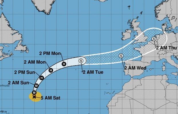
This map of the American Hurricane Center, the NHC, allows you to visualize Kirk’s forecast path. For hurricanes, beyond three days, there is greater uncertainty about the precise trajectory, hence the fact that France appears dotted. But this trend has been confirmed by all the weather models for two days. In addition, it also seems to be confirmed that the heart of the storm will cross the country rather than following it in the English Channel, as initially planned.
At this time, it remains difficult to be precise about forecasts. But as it approaches and a passage of the center of the storm over the center of the country becomes clearer, they are less and less good. Currently, in addition to the significant amounts of rain expected throughout the country, the wind speed is increasing and the extent of the areas concerned is increasing.
On an axis going from New Aquitaine to the North-Eastern borders, the remains of Hurricane Kirk would cause gusts of between 90 km/h and 100 km/h. This would be the limit between the winds of a depression and those of a storm. But this speed, especially in certain regions which are little exposed to it and at a time of year when the trees are still very heavy since the leaves have not yet fallen, constitutes a threat to be taken seriously.