Hurricane Kirk, downgraded to an extratropical storm, will sweep across France from Wednesday October 9 to Thursday October 10. Violent gusts of wind and heavy rain are expected over a large northern part of the country.
The weather is far from good this week. After the Cévennes episode which affected the southern half of France at the start of the week, a storm will sweep across French lands from Wednesday October 9. Hurricane Kirk, which is developing in the middle of the Atlantic Ocean, downgraded to category 1/5, continues to weaken to become an extratropical storm, and it is this storm Kirk which will blow over France from west to east between Wednesday and Thursday according to the weather forecast.
Storm Kirk is expected to hit the Bay of Biscay from late Wednesday and affect a large northwest quarter before gradually sliding northeast. “An orange vigilance for the countries of the Loire in the Paris basin will probably be issued” for the day of Wednesday October 9 warns Météo France. Vigilance should concern winds and the risk of rain and flooding.
Gusts of more than 100km/h expected
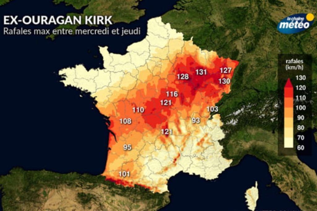
Storm Kirk will essentially bring strong winds. The gusts could reach 100 to 120 km/h on the French sides and blow between 80 and 100 km/h inland with no significant weakening expected along the way between the western and eastern regions. According to forecasts from La Chaîne Météo, the maximum gusts could even be more powerful in the east than in the west with peak winds between 127 and 131 km/h announced in the Grand Est. A phenomenon explained by a conflict between two air masses: Storm Kirk will be pushed by warm air coming from the southwest, but will encounter cold air in Brittany which could encompass the depression and strengthen it. The trajectory of the storm, which still needs to be refined, seems to pass through the Pays de la Loire, Center-val-de-Loire, part of Burgundy and the Grand Est.
In lands near the Bay of Biscay, gusts could reach up to 110 km/h. Weather agencies warn, however, that uncertainties remain over the precise path of Storm Kirk, as well as the intensity and timing of severe weather. The Windy app models weather data and allows you to visualize Storm Kirk and its progress. Here the gusts of winds and their evolution are visible. It is possible to observe single winds and wind accumulation by choosing the appropriate filter with the button at the top right of the image.
The winds generated by Storm Kirk should be the main danger, they can cause trees or objects to fall. If you are vigilant, it is recommended to protect your home and secure or bring in any exterior objects that could be taken away. It is also preferable to limit your travel and stay informed of the situation via the authorities. The risks are all the greater when heavy rains are combined with violent winds.
Heavy rains in the northwest
In addition to stormy winds, Depression Kirk is expected to bring heavy rain to a large northwest part of the country. “The highest rainfall totals are expected from the northwest to the Belgian borders, with 20 to 40 mm, locally 70 mm” forecasts Météo France. The Pays de la Loire, Brittany, Normandy, Centre-Val-de-Loire, Ile-de-France, Hauts-de-France as well as part of the Grand Est are likely to see heavy rainfall between Wednesday and Thursday. The soils in these regions are already saturated with water, “the risk of hydrological reaction will need to be monitored” warns La Chaîne Météo.
Under the effect of Storm Kirk, swell is expected on the Atlantic coasts, particularly in the Bay of Biscay. Waves of 4 to 6 meters are expected especially south of Gironde. The risk of submersion will be limited by the low tidal coefficients.
Latest updates
10:30 – 19 departments on orange alert this Wednesday
Météo France has just announced 19 orange alerts for the day of Wednesday October 9 in view of the passage of Storm Kirk. Two departments of the Pyrenees are on alert for the wind from 6 a.m. to 9 p.m. because “the gusts could reach 120 to 150 km/h on the summits and 100 to 110 km/h in the valleys and on the plains”. 17 other departments are on alert for rain flooding from the Pays de la Loire coast to Ile-de-France. “The accumulations over the whole day will be very significant, they could reach 40 to 60 mm in the Paris basin and 60 to 80 mm, or even locally 90 mm heading towards the Loire and Vendée regions” specifies Météo France .