Heavy downpours ahead of the weekend have given way to a brief respite before a fresh weather warning kicks in with more torrential rain and possible thunderstorms on the way.
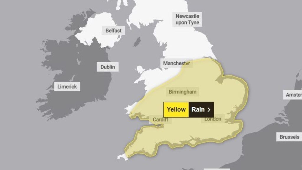
The Met Office has issued a yellow weather warning for heavy, possibly thundery rain from 9pm on Saturday until 6pm on Sunday across all of south and central England and Wales, reaching as far north as Hull in the east and Manchester in the north west.
Forecasters say it is likely to cause flooding and disruption in parts of England and Wales on Saturday night and Sunday, with a chance of flash flooding, power cuts and travel disruption.
It comes after parts of southern England were deluged with rain on Thursday and Friday, with almost a month’s worth of rain falling in the space of two days.
West Dunkery in Devon had up to 75mm in two days, according to the Met Office. The month’s average rainfall in the southwest is normally 93mm.
Ahead of Saturday’s weather warning, there will be some better conditions for parts of the UK.
Scotland, Northern Ireland and East Anglia are expected to see the best of the weather on Saturday with Norwich hitting a high of 24°C.
BBC weather meteorologist Darren Bett said: “It’s going to be quite a warm start to Saturday, muggy as well and because of that you have got extensive low cloud, some mist and fog.
“Things may improve a little. It looks dry for Scotland and Northern Ireland, sunny for the most part with that low cloud retreating to the east coast of Scotland.
“In the sunshine in Scotland and Northern Ireland, temperatures into the mid 20s and it may warm where we get a bit of sunshine up in East Anglia.”
As well as the high in East Anglia, parts of central Scotland could reach 23°C on Saturday but the dry, warm spell is not expected to last long as heavy rain will be coming in from the south overnight.
“We’ve got this area of low pressure bringing wetter weather overnight on Saturday with heavy rain and some thunderstorms perhaps”, said Mr Bett.
The band of wet weather is expected to move northwards overnight, affecting central and southern England and Wales, according to the Met Office.
Forecasters say a “plume of wet weather arrives from the continent bringing outbreaks of quite torrential rain for many areas overnight”, after a series of warnings for heavy rain at the end of this week.
Met Office forecaster Annie Shuttleworth said the heavy rainfall could cause some surface water issues on Sunday morning.
The rain is expected to stay clear of the far north and west but there will be a very wet start for many on Sunday.
“It could stay quite wet through a lot of the day”, said Ms Shuttleworth, “There could be some localised flooding and travel disruption due to this heavy rain, particularly across parts of Wales and central England.
“There’s further risk of some thundery outbreaks of rain as well and despite the milder air arriving from the south, with a lack of sunshine temperatures just around 18 to 21C at best and its going to be a cooler day for the north west on Sunday as well.”
There are also likely to be spells of heavy rain and thundery showers across many central and southern areas, although it is expected to remain largely dry but cloudier elsewhere.
A north westerly wind is expected to arrive on Sunday which could bring some change to the weather for the start of next week, with cooler, fresher temperatures but also the possibility of more rain.
Met Office deputy chief meteorologist Dan Harris said: “Reminiscent of this time last week, the forecast for later this weekend comes with larger uncertainties than average.
“This is due to a more complex than usual meteorological pattern involving multiple corridors of heavy, locally thundery rain revolving around a slow-moving area of low pressure.
“We are keeping warnings under review, and will look to issue them over the weekend as confidence increases, so please keep up to date with our latest forecasts and warnings.”
The Environment Agency has one flood alert currently in place for the Rivers Clyst and Culm and their tributaries in Devon, with flooding possible in low-lying areas and on roads close to the rivers.


