Par
Sebastien Lucot
Published on
Nov. 2, 2024 at 8:20 a.m.
See my news
Follow La Presse de la Manche
It brought back the specter of “ storms of the century » Lothar and Martin who swept France at the end of the last century. In Manche, Finistère and Côtes-d’Armor, this major meteorological phenomenon revived dark memories of the storm of the night of October 15 and 16, 1987, renamed a “hurricane” by the media.
Almost a week before this event which caused the death of three people in France and gusts exceeding 200 km/h on the Breton tip, the Ciarán storm was already foreseen by the weather models. Good predictability which allowed the triggering of the red alert “violent wind” by Météo-France forecasters in these three departments and thus best prepare the means to be deployed by State services, warning the populations and the authorities.
If the consequences were a little less virulent than in 1987 in the Channel, the damage caused by the gusts of wind were numerous on the evening of 1is November, until the end of the morning of November 2.
Exceeding 170 km/h on the Manche coast and sometimes more than 150 km/h inland, these values are the perfect signature of a “ weather bomb », term used in meteorological jargon to designate the sudden deepening of a depression, causing the atmospheric pressure to plunge to its center and thus tightening the pressure gradient, vector of violent squalls.
Gusts
Some
171 km/h at Pointe du Roc in Granville;
167 km/h in Gouville-sur-Mer;
166 km/h at Chausey;
159 km/h at Barfleur – Gatteville-le-Phare;
157 km/h at Carteret (loss of data from 4 a.m.);
153 km/h in Saint-Vaast-la-Hougue;
140 km/h at Cerisy-la-Salle;
139 km/h in Longueville;
133 km/h in Sainte-Marie-du-Mont;
131 km/h at Cap de la Hague.
Brittany
207 km/h at Pointe du Raz;
195 km/h at Ile de Batz;
193 km/h at Pointe de Saint-Mathieu.
The “optimal” phasing of this depression, taken at the heart of a high-altitude current, called jet-stream and blowing at more than 330 km/h at 9,000 meters altitude, amplified this sudden fall. An average wind of force 12 (118 km/h over 10 minutes, start of the classification, at sea, of a hurricane) was recorded off the coast of Brittany.
In the Channel, Ciarán's anger unfolded in two stages. The first, in the evening, as it approaches its eye pointed at 956.1 hectopascals by the Cap de la Hague meteorological station.
What about climate change?
This first salvo caused significant damage in the center of the department with a southerly wind exceeding 140 km/h in Cerisy-la-Salle. At daybreak, the scars of this restless night were visible in Saint-Lois and Coutançais. Trees on the ground, electric wires strewn on the roads, roofs blown away…Every move was a challenge.
Strengthen the electricity network
The thousands of trees that fell under the power of the gusts damaged a large part of the department's electrical network. On the morning of November 2, up to 125,000 homes in Manche were without electricity, 300,000 in Normandy and 1.2 million in France. Nearly 600 incidents were recorded on the high voltage network (20,000 volts) in Normandy (220 in Manche) and 850 incidents on the low voltage network (295 in Manche).
This climatic event, well anticipated by Météo-France, allowed the main French electricity distributor, Enedis, to “pre-mobilize our teams”, reports Fabrice Douillet, director of territorial affairs in Normandy. By deploying its Rapid Electricity Intervention Force (FIRE), Enedis was able to mobilize in Normandy, from November 1, 1,000 technicians from around ten units from other regions. “In our region, 95% of our customers had electricity restored on November 5. The last one was 11 days after Ciarán.”
To reduce the risks of power outages during climatic hazards, Enedis intends to activate several levers over the coming years. Continue to bury electrical networks, modernize its lines and change bare wires, cables that can collide and are more exposed. “Usually, every five years, we reinforce 3,500 kilometers of lines in Normandy. We will do 2,000 more over this same period,” assures Fabrice Douillet. Investments which could have consequences on the price of electricity, Enedis asking to increase the Tariff for use of the public electricity network (Turpe), visible on each French electricity bill.
At this same time, the shift in winds to the west swept an axis going from Saint-Sauveur-le-Vicomte and Coutances between 5 a.m. and 9 a.m.
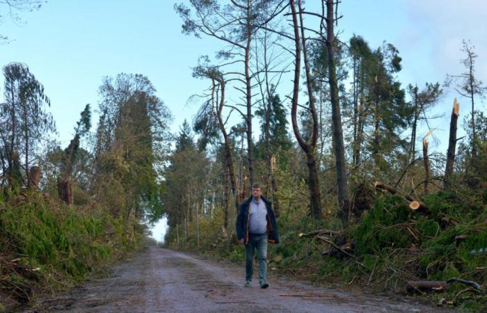
This moment signing theparoxysmof this extraordinary storm, partially razed certain forests in the department. Lande de Lessay, forest of Saint-Sauveur-le-Vicomte… Near Périers, “on the 72 hectares belonging to the municipality, 80% of the trees were destroyed. We had never seen that, even in 1999,” noted Jean-Luc Launey, mayor of Saint-Patrice-de-Claids, a few days later.
Is this extreme meteorological phenomenon, even for a territory accustomed to storms, attributable toclimate change ?
If rising global and ocean temperatures increase the risk of intense precipitation and drought in Europe, “there is no clear scientific consensus on the effect of climate change on the evolution of the frequency or intensity of storms in France. We have not observed any significant trend in past developments for more than 40 years,” explains Météo-France.
Follow all the news from your favorite cities and media by subscribing to Mon Actu.


