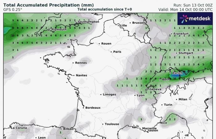
The past week was marked by abundant precipitation, mainly linked to the passage of ex-Hurricane Kirk, and leading to exceptional flooding around the Paris basin in particular. What will it be like for thenext week (October 14 to 20) ?
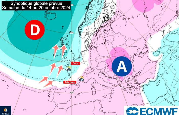
The global overview of the coming week should see our country located between two major centers of action: a anticyclone positioned towards Eastern Europeand a vast low pressure system located off the coast of the British Isles. In this configuration, it is a gentle or very gentle southern flow which will concern our regions in the coming days… before the return of humidity by the Atlantic but also on the shores of the Mediterranean.
Planned global synoptic – week of October 14 to 20, 2024 – ECMWF
A week marked by gentleness or even warmth
These last few weeks have been marked by often cool temperatures in our country, marking the strong arrival of autumn. However, the flow from South to South-East which will concern us at least until mid-week should cause a widespread rise in temperatures.
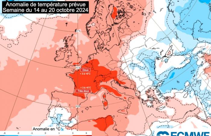
It is indeed the mildness that will be present in mid-October, since we could position ourselves according to the latest scenarios of +3 to +6°C above average seasonal depending on the region. It is our country which will have the highest excess temperature during this week.
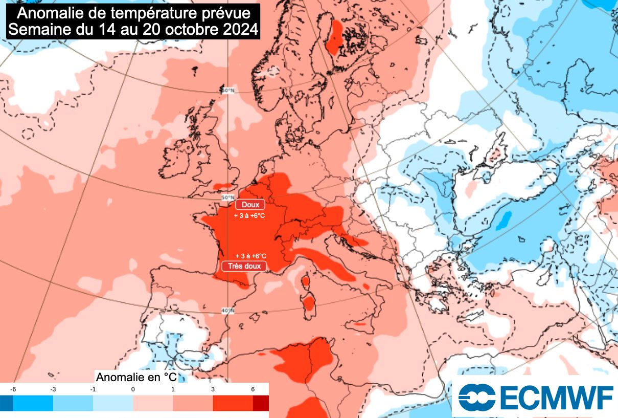
Predicted temperature anomaly – week of October 14 to 20, 2024 – ECMWF
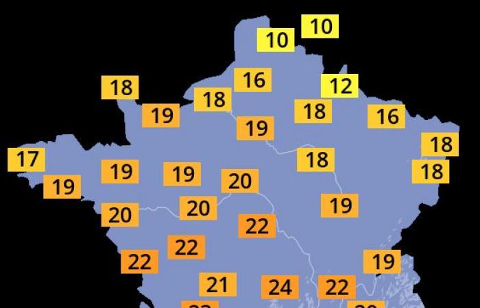
Already this weekend, mildness has settled in the South-West quarter with temperatures above 20°C, or even up to 25°C at the foot of the Pyrenees as well as on the Basque coast. It is this sweetness which should spread over the days towards the northern regions : the 20°C mark will be reached as far as the north of the country in the middle of the week, while the heat threshold (25°C) will continue to be exceeded in the South-West, and more isolated by the Foehn effect on Corsica, in the Limagne plain (Clermont-Ferrand) or in certain Alpine valleys.
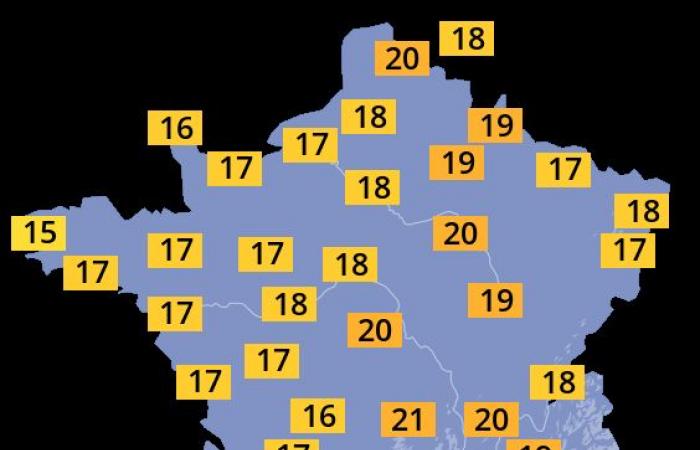
These temperatures will initiate a drop from Thursday in the west of the country (due to rainy conditions). But the air will remain sweet, especially in the morning when the thermometer will remain significantly above 10°C, or even beyond 15°C in the cool of the night in a large number of departments.


Forecast maximum temperatures – Monday 14 and Tuesday 15 October 2024 – Weather-Cities


Forecast maximum temperatures – Wednesday 16 and Thursday 17 October 2024 – Weather-Cities
Humidity, and a risk of a marked Cévennes episode
Unfortunately, we will still have to wait to return to dry and calm anticyclonic conditions. Because this sweetness will also be accompanied byhumiditywhich will increase significantly in the second part of the week.
Indeed, the low pressure system over the near Atlantic should gradually gain ground before impacting France and all of Western Europe, once again bringing its share of pabundant precipitation especially from Wednesday. By next weekend, it’s a large western part of France which will be subject to notable rains which may exceed the 60 to 80mm according to certain scenarios. But the Mediterranean regions will not be left out…

Total precipitation accumulation until Sunday October 20, 2024 inclusive – GFS model via WxCharts
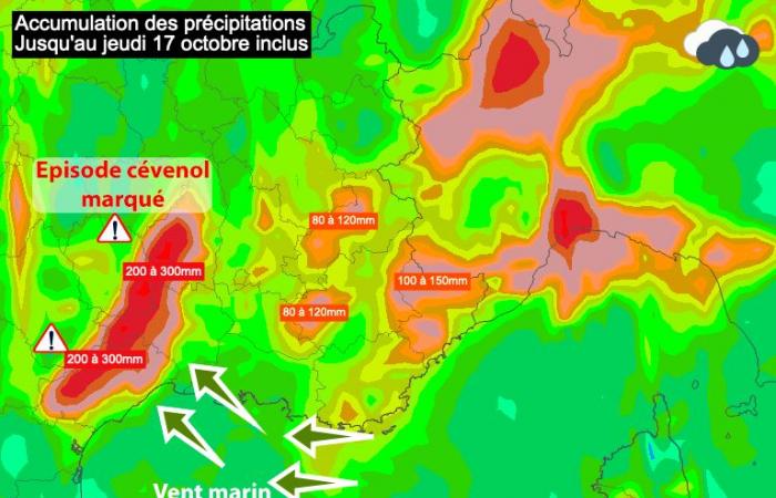
Because thanks to this flow oriented to the South-East, it is a sea air heavily loaded with humidity which will be blocked on the different reliefs and mainly on the Cévenol relief. The signal of a Cévennes rainy episode seems to be gaining ground between Wednesday and Thursdaywith accumulations that could reach 200 to 300mm within 48 hours according to certain models (the intensity of the rains will remain to be refined over the coming days).

Accumulation of precipitation until October 17, 2024 inclusive – South-Eastern France zone – UKMO models via Meteociel
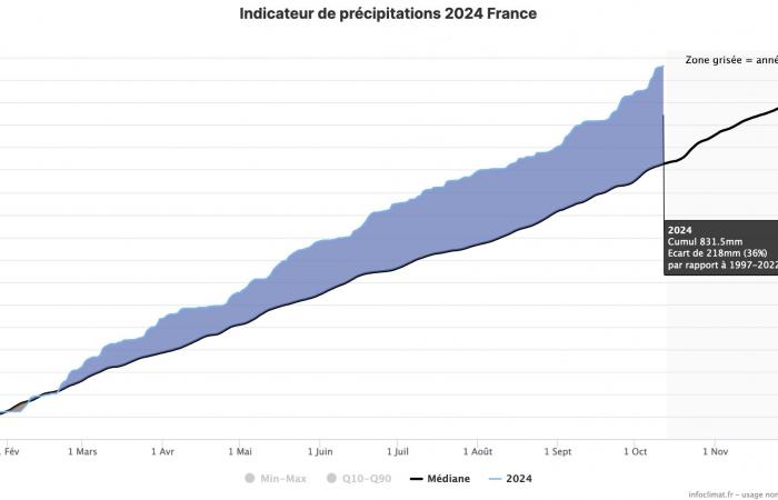
These precipitations will occur in a context of very high rainfall surplus. Since the beginning of the year, the aggregated total at the country level has reached 830mm, 35% more than normal (this is also the highest accumulation observed in mid-October in 40 years of measurements). Faced with this observation, soil humidity is already very high at the start of autumn, and the saturation is even reached in certain regionsconsequences of the flooding observed in recent days.
These new rains could therefore delay the decline in several regions affected this week, or even direct the level of several watercourses upwards again. Of new floods are therefore not to be excluded, on the one hand surroundings of the Cévennesand on the other hand on the Paris basin and Center-Val-de-Loire if these predictions are confirmed.

National precipitation indicator for the year 2024 (as of October 12) – Association Infoclimat


