

Par Briac Trébert Published on May 8, 2025 at 11:08 a.m.
The Météo France vigilance map finally turns green, after a sequence of sometimes violent thunderstorms.
Saturday May 3, Several tens of thousands of lightning had been recorded in France and damage reported in particular because of the hail, from Paris to the southwest. It will finally be the lull everywhere this Thursday, May 8, 2025. But it will not last.
The scenario of last weekend could well be repeated, even if ground temperatures will be lowerreducing the shock of air masses and very violent phenomena a little.
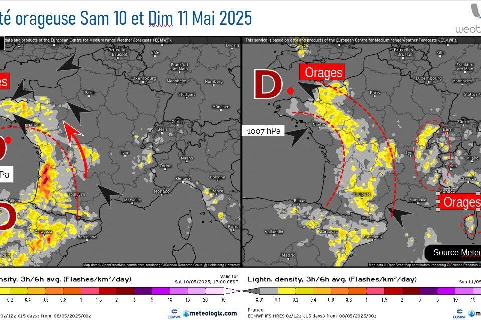
This Saturday, May 10, thunderstorms should form along the Atlantic facade and on the main mountain massifs, but Sunday, May 11, they should progress in the interior and concern a large part of the western half of France. They should then be more organized and more virulent than the day before. Monday 12 and Tuesday 13, notable thunderstorms are expected this time on the eastern facade of the country…
“Episodes of hail and strong precipitation”
“The thunderstorms will come back to the Southwest once again from this weekend of Saturday May 10 and Sunday May 11, 2025. Episodes of hail and strong precipitation are still possible, especially in the southwest and the west, ”warns already on actu.fr Meteorologist Yann Amice, supporting cards.
From this Friday, May 9, 2025, a dozen departments (the departments of Ain, Alpes-de-Haute-Provence, Hautes-Alpes, Alpes-Maritimes, Cantal, Doubs, Isère, Jura, Loire, Haute-Loire, Lozère, Puy-de-Dôme and Pyrénées-Atlantiques) will be vigilant for first risks sequence.
The wind will switch this Friday, May 9 in the southeast sector on Friday, May 9, bringing up to the warmer air from France from North Africa. But instability will come back, due to the presence of cold air at altitude which will slide once again from the west. new convergence phenomena in low layers will be monitored with risks of strong showers and hail in several regions during this weekend of Saturday May 10 and Sunday 11, especially in the Nantes, Rennes, Angers and South-West sectors.
-
After a very very fresh start to the week, and temperatures under season medium-sized due to a fleece and a sensitive north-north-east wind, Mercury will go back from this Friday, May 9 because the wind will switch to the east, then southeast sector.
Temperatures will often earn more than 10 ° C between this Wednesday, May 7 and this Saturday, May 10! A veritable Yo-Ias since the beginning of the month.
A depressional system (still) in the south of Spain
If the 30 ° C mark will not be reached this time, the heat threshold (25 ° C) could be this Saturday May 10 in Aquitaine (26 ° C provided for in Biarritz) and Sunday May 11 in the north of the Loire (25 ° C in Lille, 26 ° C in Paris). But instability will soon come back too.
The scenario will be the same as for weeks. While a anticyclone is well rooted in the North Sea, a Deeptory system will once again position itself in the south of Spain, before going back to the west of France.
Temperature increase… and return of thunderstorms
A context favorable to the rise in temperaturesbut also to thunderstorms with a conflict of air masses: cold air at altitude and hot air in the low layers, like last weekend with a beautiful dynamic of low layers to promote ancestor.
According to the weather models, the first storm showers could touch the southern half so this Friday, May 9 in isolation, and should be structured more on Saturday May 10 and especially Sunday, May 11, in the west essentially, in a warmed atmosphere.
Storms that should shift east on Monday, May 12 and Tuesday, May 13. Before temperatures rebuilt everywhere from Tuesday, May 13.
Follow all the news in your favorite cities and media by registering for my news.


