Par
Sebastien Lucot
Published on
Jan 23, 2025 at 8:11 p.m.
Red alert, highest meteorological levelissued by Met Eirann – the equivalent of Météo France services – for three days, crisis meeting par the authorities, shutdown of all transport…
The tone set by the Irish ce Thursday January 23, 2025is serious. Same thing on the side of Englishspeaking of “ storm of the century ».
Storm Éowyn
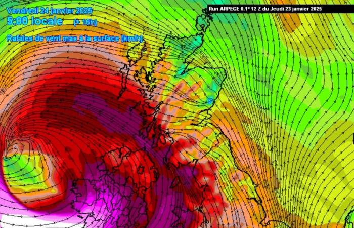
On the night of January 23 to 24, a storm, named Éowyn, will cross the British Isles from east to west. These regions, although accustomed to strong winds in wintertook this event very seriously.
And there is reason, since the weather models have detected a very deep depression, with gusts that can reach, or even exceed, 200 km/h over the west of Ireland in the Galway sector, with an average wind of the order of 150 to 160 km/h.
Gusts of 200 km/h
Across the whole of this country and over a central strip of England, gusts can reach 160 to 180 km/h, even inland.
Values that are beyond comprehension to Western Europesince these speeds fall into category 2, or even 3/5 of Saffir-Simpson, a scale for classifying the intensity of tropical cyclones.
If Éowyn is as powerful as certain destructive cyclones, she does not have the same physical characteristics that these phenomena usually distributed around the equatorial belt. This storm cannot therefore be qualified as such.
However, British meteorologists are talking about a “weather bomb”. Indeed, certain depressions have the particularity of deepening very quickly, generally propelled by a powerful high windle jet-stream.
-Which was the case again recently, for storm Ciaran on November 2, 2023 having hit hard the Some and the Brittanyor the Lothar and Martin storms at the end of 1999 in France (210 km/h in Granville).
In fact, Éowyn will “deepen very strongly (typically more than 24 hPa in less than 24 hours). We then speak of explosive cyclogenesis. This is the case for Éowyn, with the pressure expected to increase from 970 hPa on Thursday at 12 p.m. UTC to 940 hPa on Friday at 6 a.m. UTC when it passes just to the north of Ireland,” indicates Météo France, following also the phenomenon.
An otherwise rare occurrence, a fighter plane hurricanes of the National oceanic and atmospheric administration (NOAA) des UNITED STATESwas spotted at Shannon Airport in the southwest of Ireland. During the night from Thursday to Friday, he had to take off to follow and cross Éowyn in order to collect as much data as possible pour refine forecasts of this type of phenomenon.
Maritime connections canceled
Due to this storm, several maritime connections between Cherbourg and Ireland are canceled over the coming days. “The companies’ schedule is turned upside down. The ferries are seeking shelter,” comments the port of Cherbourg.
On the Cherbourg – Dublin line, Irish Ferries' Isle of Inisheer – which replaces the WB Yeats under repair – has canceled its rotations on Thursday 24 and Saturday 26 January. That of Friday January 25 of the Brittany Ferries Cotentin ferry is also canceled in Cherbourg and Rosslare.
A simple gust of wind in France
The France narrowly avoided this extraordinary storm that passed among our neighbors across the Channel. On the scale of the northern hemisphere, a shift of a few hundred kilometers further south – to the north of France – would have been entirely possible.
On the sidelines of Éowyn, theCotentin will nevertheless be swept away by some strong gusts this Friday morning at dawn, of the order of 100 to 110 km/h on the capes. Half as violent as for the third largest island in Europe, Eire.
According to the Met Eirann, for Ireland, the wind record (gusts), all months combined, is 182 km/h at Limerick (Foynes Airport), on January 18, 1945.
Follow all the news from your favorite cities and media by subscribing to Mon Actu.


