Par
Laurent REBOURS
Published on
Jan 21, 2025 at 5:11 p.m.
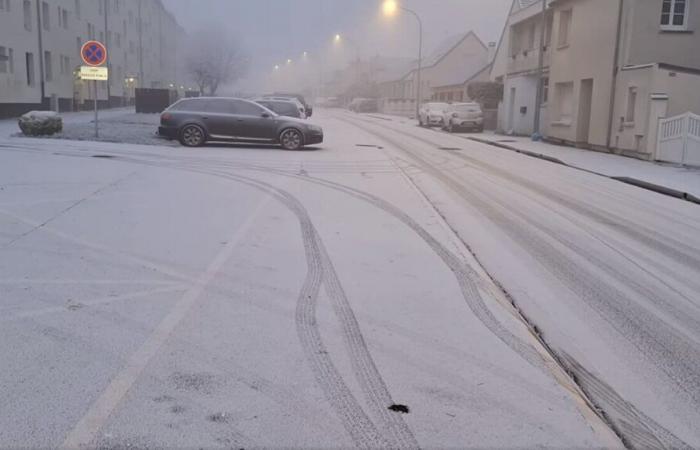
The inhabitants of Lucé (Eure-et-Loir) near Chartres did not fail to be surprised this Tuesday January 21, 2025 in the morning, discovering – just like in certain towns located (notably near industrial zones) in a north-western part of our Centre-Val de Loire region – a snowy phenomenon.
What we now call industrial snow appeared in a manner very localizedas in Eure-et-Loir in Lucé… How such a phenomenon occurs, explanations with Météo Center in particular on the health risks.
Several ultra-localized episodes
Industrial snow was once again observed locally in Saran (Loiret), Châteauroux (Indre), Saint-Cyr-en-Val (Loiret), Lucé (Eure-et-Loir), this Monday January 20 and Tuesday January 21, 2025 as the Météo Center had predicted…
For these two days, the weather conditions (calm weather, low clouds and fog, negative temperatures and pollution) “were conducive to the formation of industrial snow in a localized part of certain towns in our Centre-Val de Loire region” summarizes Météo. Center.
This was the case in Saran (Loiret) and Châteauroux (Indre) this Monday morning and Saint-Cyr-en-Val (Loiret) and Lucé (Eure-et-Loir) this Tuesday morning.
How is classic snow formed?
Three conditions are necessary for snow to form:
- The air mass temperature (at all altitudes) must be very close to 0°C or less than 0°C,
- The water vapor must be present in fairly large quantities in the atmosphere
- Of tiny volatile particles (dust, sand, etc.) must be present in sufficient numbers in the atmosphere.
In France, snow generally falls on the plains when the temperatures under shelter are included between -5°C and +1°C.
We find snowy episodes in the plains from the end of November until April most of the time. However, it is possible to observe early snowfall in October but also late snowfall in May.
How is this “industrial” or “pollution” snow formed?
■ Situation normal
In a normal situation, the higher you go in altitude, the more the air temperature decreases (around 6.5°C on average every 1000m) up to the tropopause. Warm air masses and pollutants can escape into the troposphere quite easily.
■ Temperature inversion situation
In a temperature inversion situation, the temperature gradient is positive or zero (the temperature rises with altitude). As cold air is heavier than warm air, the latter sinks towards the ground, while the other rises. The inversion layer can range from a few tens of meters to several hundred meters. This thermal inversion is mainly observed in winter. Indeed, as the sun is low in the sky and does not heat the ground very much, the thermal inversion does not fade so easily.
-■ A situation conducive to the formation of industrial snow
In winter, during anticyclonic conditions, we observe a strong temperature inversion. The cold air remains pressed against the ground and prevents pollution particles from “escaping”. Fog is generally observed near the valleys during these calm and cold weather. Coupled with pollution linked to industries and transportthe humidity present in the air makes it possible to fill the ambient air with solid particles (condensation nuclei).
The water vapor attaches to these and transforms into very fine snow. This is only the case when the weather conditions are favorable (negative temperature and absence of wind). We find this so-called “industrial” snow, particularly near polluted areas (industrial zones). Nuclear power plants also bring large quantities of water vapor into the air, promoting the phenomenon of industrial snow (excess humidity).
What is the difference between natural and industrial snow?
The same formation process is observed for natural snow and industrial snow: water vapor attaches and condenses on solid particles (condensation nuclei).
“Natural” snow forms at altitude during disturbed passages (rain-snow front/snow front). It affects large to very large areas (departmental scale, regional scale, national scale).
Conversely, industrial snow forms in low layers under very specific conditions (anticyclonic conditions without disturbed passage and without wind with cold, humidity and pollution particles stuck close to the ground). It affects very small areas (municipal scale, local scale).
This industrial snow is therefore only observed when conditions are anticyclonic. They are therefore non-depression with the presence of a high level of humidity and cold (negative temperatures) in low layers. In addition, to this is added fine pollution particles (often present near industrial areas).
Is industrial snow harmful to health?
Industrial snow is often linked to the presence of numerous fine particles of pollution in lower layers.
Road traffic (more active and dense traffic in winter linked to weather conditions and longer nights), wood/oil heating and factories (industrial zones) are sources of emissions of these fine particles. This “special” snow allows us to see the atmospheric conditions at low levels. In this situation, we have a significant concentration of fine particles: it makes this hidden pollution present in the air “visible”!
Fine particles represent a health hazard“particularly in winter because of toxic combustion particles present in the air (particularly when burning fuel oil, diesel or when heating wood, etc.). We can develop cardiovascular and respiratory problems and even cancers » recalls Météo Center.
Is industrial snow on the ground a danger?
“It is better avoid playing with it and do not swallow it » immediately warns Météo Centre.
With one caveat, however, “it remains not very toxic for our body. Indeed, the quantities of fine particles are generally very low/tiny in the snow that falls on the ground.”
Pollution is mainly present in the air around us.
To find out more with numerous diagrams, it's HERE
Follow all the news from your favorite cities and media by subscribing to Mon Actu.


