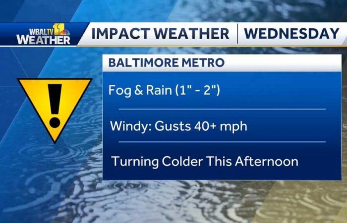
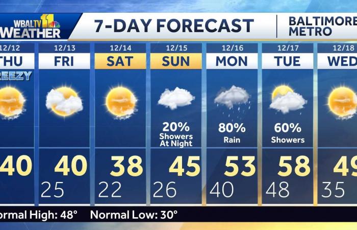
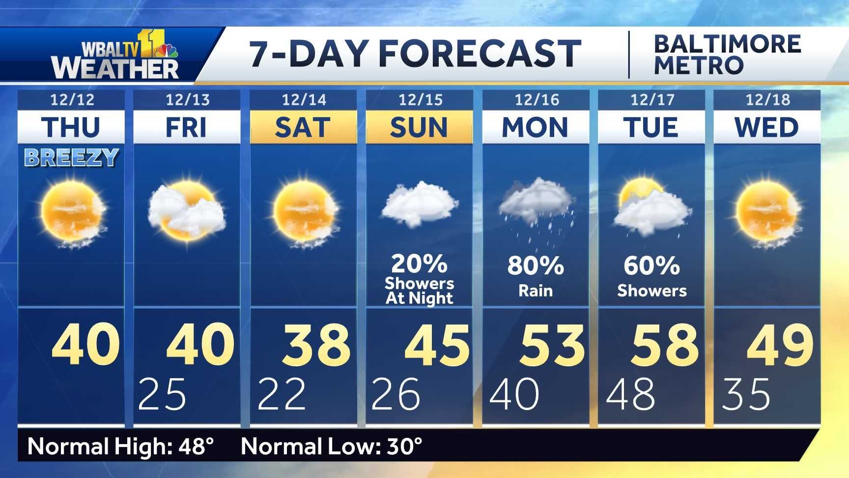
LEADERSHIP. NOW, YOUR WBAL, TV 11 WEATHER FORECAST WITH METEOROLOGIST ALINA LEE. WELL, TODAY’S AN IMPACT WEATHER DAY WITH WIDESPREAD STEADY RAINFALL THAT HAS CONTINUED TO MOVE ACROSS THE PARTS OF BALTIMORE. EVEN THE ENTIRE STATE OF MARYLAND. DRENCHED RIGHT NOW FROM EARLIER RAINFALL. AND WE’RE GOING TO CONTINUE TO TRACK THIS RAIN FOR SEVERAL MORE HOURS. I DO WANT TO JUST GIVE YOU A LITTLE BIT OF AN UPDATE OF DOPPLER RADAR, ESTIMATED RAINFALL TOTALS. SO THESE ARE NOT FROM PARTICULAR SENSORS ACROSS THE AREA. THIS IS JUST WHAT THE DOPPLER RADAR HAS ESTIMATED AS FAR AS HOW MUCH RAIN WE’VE SEEN SO FAR OVER THE LAST 24 HOURS, AND SOME LOCATIONS HAVE PICKED UP OVER AN INCH, ALMOST AN INCH AND A HALF. IN SOME SPOTS WHERE YOU CAN SEE THOSE AREAS OF GREEN ANYWHERE THAT’S COVERED IN THE BLUE TURQUOISE COLOR, LIKELY SEEING ANYWHERE BETWEEN A HALF TO ALMOST AN INCH OF RAIN. AND THERE IS STILL ANOTHER ADDITIONAL HALF TO AN INCH AND A HALF EXPECTED IN SOME SPOTS, ESPECIALLY WHERE THAT HEAVIER RAIN IS AT THE MOMENT. WE ALREADY HAD A QUICK DOWNPOUR HERE AT THE STUDIO. OF COURSE, THAT RAIN CONTINUING TO SHIFT OFF TO THE EAST AND THIS ENTIRE STORM SYSTEM WILL CONTINUE PUSHING OFF TO THE NORTH AND EAST. AND BEHIND IT, THE COLD FRONT, OR AT LEAST THE COLD FRONT, WILL BRING US THE COLDER AIR BEHIND IT. SO THAT’S GOING TO BE EXPECTED AS WE MOVE THROUGH TONIGHT. AS YOU’LL NOTICE HERE ON LIVE RADAR, THOUGH, THE HEAVIEST RAIN IS HEADED STRAIGHT FOR BEL AIR. MOVING OUT OF TOWSON AS WE SPEAK AND HEADED TOWARDS COCKEYSVILLE, YOU MAY ENCOUNTER A LITTLE BIT OF A BRIEF DOWNPOUR, BUT IT WOULD NOT LAST LONGER THAN MAYBE 10 TO 15 MINUTES. THAT’S HOW QUICKLY THAT BAND OF HEAVY RAIN IS MOVING THROUGH. NOW WE MOVE SOUTH A LITTLE BIT, IMPROVING A LITTLE BIT FOR AS FAR AS THE HEAVIER RAIN IN BALTIMORE, BUT STILL RAINING AT THIS POINT. AND EVEN JUST SOUTH OF OUR VIEWING AREA. STILL SEEING SOME RAIN OUT THERE THAT IS MODERATE TO EVEN JUST A BIT HEAVY BETWEEN ANNAPOLIS AND STRETCHING OVER TO CENTERVILLE DOWN TOWARDS EASTON. SO THAT’S WHAT’S GOING ON RIGHT NOW AS WE MOVE AHEAD TO THE REST OF THIS AFTERNOON INTO THE EVENING, THE RAIN WILL GRADUALLY TAPER OFF FROM WEST TO EAST AND OUR TEMPERATURES WILL GRADUALLY FALL THROUGHOUT THE DAY. RIGHT NOW, BALTIMORE AT ABOUT 63 DEGREES, IT’S PROBABLY THE WARMEST WE’RE GOING TO GET ALL DAY. IT’S ONLY NOONTIME, AND THEN AFTERWARDS WE’RE GOING TO SEE TEMPERATURES IN THE 50S AND THEN QUICKLY IN THE 40S. BUT AFTER MIDNIGHT, ONCE THE CLOUDS CLEAR, AS YOU’LL NOTICE HERE AT 2:00 IN THE MORNING, FUTURECAST INDICATING TEMPERATURES CLOSER TO FREEZING AT THAT POINT, AND WITH A LOT OF MOISTURE ON THE GROUND, ANY ELEVATED SURFACES COULD BECOME A BIT SLICK. SO WE DO WANT YOU TO BE CAREFUL TOMORROW MORNING AS YOU HEAD OUT THE DOOR, BECAUSE ANY WET PAVEMENT OUT THERE, ESPECIALLY ON THE BRIDGES AND OVERPASSES, THERE COULD BE PATCHES OF SLICK SPOTS. I’M NOT EXPECTING IT TO BE A SHEET OF ICE, BUT JUST BE CAREFUL AS YOU DRIVE AROUND THE AREA. TOMORROW MORNING MID DAY. ONCE WE GET THE SUN TO COME OUT AND WARM THE PAVEMENT, ANY OF THOSE SLICK SPOTS WILL QUICKLY BECOME WET. AND OF COURSE WE’LL BE DRYING OUT THROUGHOUT THE DAY ON THURSDAY AS TEMPERATURES HOLD IN THE LOW 40S OR EVEN UPPER 30S. IN ADDITION TO THE HALF TO INCH AND A HALF OF RAIN THAT WE’VE SEEN ACROSS PARTS OF OUR VIEWING AREA, THERE COULD BE AN ADDITIONAL HALF TO AN INCH POSSIBLE. AGAIN, THERE COULD BE SOME SPOTS THAT SEE A LITTLE BIT OF PONDING, MAYBE SOME ISOLATED FLASH FLOODING OUT THERE WITH THOSE HEAVIER DOWNPOURS, BUT NOT WIDESPREAD. SO MOVING ACROSS OVER THE NEXT SEVEN DAYS, LOW 40S EXPECTED FOR THE REST OF THE WEEK, AND THEN A GRADUAL WARM UP NEXT WEEK, BUT
Impact Weather for Maryland with heavy rain, wind gust and falling temps
Updated: 3:40 PM EST Dec 11, 2024
Meteorologist Ava Marie says it will be an Impact Weather day for the area as heavy rain showers and high winds.|| Closings/Delays | Weather Advisories | Radar | Forecast | Email Alerts | Send us your pics ||Wednesday will start out with dense fog in some areas as the rain showers will steadily increase throughout the day. The winds will also increase to 10-25 mph with gust up to 45 mph in some places. The wind will be stronger on the Eastern Shore and areas to the south of Baltimore.Temps will begin to drop from the low 60’s to the mid 40’s by the late afternoon with steady winds from the northwest . The showers are expected to end around 8 p.m. and icy spots could be possible after 10 p.m. as temps drop to around freezing. The winds will also decrease overnight as temps will remain cold for the rest of the week in the low 40’s.| LINK: MDOT SHA’s Statewide Transportation Operations Response MapDownload the WBAL-TV app NOW and turn on push alerts to be aware of severe weather warnings, listen to NOAA Weather radio, and watch WBAL-TV 11 when impending severe weather develops.@wbaltv11 | @TTasselWBAL | @AvaWBAL | @TonyPannWBAL | @DalenciaWBAL | @AlenaLeeWXWBAL-TV 11 Maryland Weather RadarApp users tap here for interactive radar.Maryland’s 7-Day Weather ForecastAlert Days vs. Impact DaysYou may see the WBAL-TV 11 Weather Team highlight Alert Days or Impact Days in the forecasts. Here’s what that means:An Impact Day is when weather will likely disrupt your normal daily schedule or routine.An Alert Day is when there’s a threat of extreme, severe and possibly life-threatening weather.Potential power outagesStorm conditions could cause outages by knocking down tree limbs onto power lines and other electric delivery equipment. Baltimore Gas and Electric asks all customers to report their outage in any of the following ways: Online, at BGE.comBGE’s free mobile app, available at the Apple Store or Google Play Text message, to 69243 Phone, by calling 877-778-2222The latest outage information, including total number and general locations, is available on the BGE.com outage map.As a reminder, fallen overhead power lines should never be approached or touched even if the lines do not appear to be live or sparking. Call BGE at 877-778-2222 to report fallen electrical lines, power outages and gas odors.Share your weather photos and videosShow us your weather photos and videos, we may use them on 11 News or online!DIRECT UPLOAD: Use this form to upload photos or video.EMAIL: Just email your photos and video to [email protected]: Severe weather alerts from the WBAL-TV app: step-by-step guideCLOSINGS: See if schools, businesses or organizations have closed or delayedRADAR: Track snow, sleet or freezing rain with WBAL-TV’s interactive radarROADS: Check for crashes and backups with our interactive traffic mapWINTER: Guide: Snow safety, driving hazards, power outagesTORNADO SURVIVAL: 5 things you need to do nowHURRICANE PREPARATION: How to prepare for hurricane season
Meteorologist Ava Marie says it will be an Impact Weather day for the area as heavy rain showers and high winds.
|| Closings/Delays | Weather Advisories | Radar | Forecast | Email Alerts | Send us your pics ||
Wednesday will start out with dense fog in some areas as the rain showers will steadily increase throughout the day. The winds will also increase to 10-25 mph with gust up to 45 mph in some places. The wind will be stronger on the Eastern Shore and areas to the south of Baltimore.
Temps will begin to drop from the low 60’s to the mid 40’s by the late afternoon with steady winds from the northwest . The showers are expected to end around 8 p.m. and icy spots could be possible after 10 p.m. as temps drop to around freezing. The winds will also decrease overnight as temps will remain cold for the rest of the week in the low 40’s.
| LINK: MDOT SHA’s Statewide Transportation Operations Response Map
Download the WBAL-TV app NOW and turn on push alerts to be aware of severe weather warnings, listen to NOAA Weather radio, and watch WBAL-TV 11 when impending severe weather develops.
@wbaltv11 | @TTasselWBAL | @AvaWBAL | @TonyPannWBAL | @DalenciaWBAL | @AlenaLeeWX
WBAL-TV 11 Maryland Weather Radar
App users tap here for interactive radar.
Maryland’s 7-Day Weather Forecast
Alert Days vs. Impact Days
You may see the WBAL-TV 11 Weather Team highlight Alert Days or Impact Days in the forecasts. Here’s what that means:
- An Impact Day is when weather will likely disrupt your normal daily schedule or routine.
- An Alert Day is when there’s a threat of extreme, severe and possibly life-threatening weather.
Potential power outages
Storm conditions could cause outages by knocking down tree limbs onto power lines and other electric delivery equipment. Baltimore Gas and Electric asks all customers to report their outage in any of the following ways:
The latest outage information, including total number and general locations, is available on the BGE.com outage map.
As a reminder, fallen overhead power lines should never be approached or touched even if the lines do not appear to be live or sparking. Call BGE at 877-778-2222 to report fallen electrical lines, power outages and gas odors.
Share your weather photos and videos
Show us your weather photos and videos, we may use them on 11 News or online!

