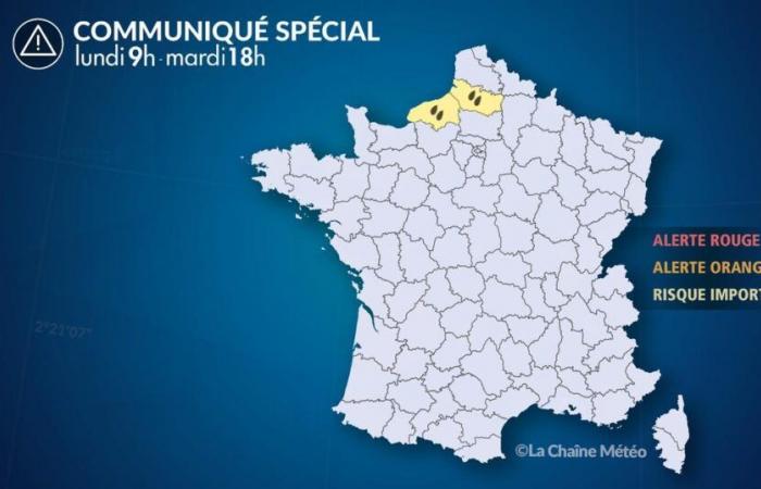
Of
Monday, November 18 at 9:00 a.m. au
Tuesday November 19 at 6:00 p.m.
Situation
This Monday, a disturbance descends from the British Isles. Slowed in its progression by the anticyclone which resists in the south of France, it stagnates for a large part of the day from the Channel coast to Belgium. After a relative calm during the night, the weather becomes unstable on Tuesday with further rain or showers accompanied by strong winds. Improvement will not occur until late Tuesday afternoon after the disturbance's cold front passes.
Between Monday and Tuesday evening, we expect rainfall totals of 40 to 50 mm on average, but they could locally reach 60 to 80 mm, corresponding to 3 weeks of rain in the month of November.
These heavy rains are likely to cause some hydrological reactions and a very localized risk of flooding, particularly in the region from Caux in Seine-Maritime to the Somme estuary, the sectors most affected by this heavy rain.
Over the next few days, with the onset of a very turbulent, increasingly wintery period, other alerts will be issued by our services for gales and risks of snow up to the plains.
Observation
At 9 a.m., we observed an area of heavy rain between the Côte d'Albâtre and the Amiénois with rainfall intensities of 10 to 15 mm/hour. We recorded 53 millimeters of rain in Eu (Seine-Maritime), the equivalent of more than 15 days of rain, 40 mm in Oisemont (Somme), 26 mm in Aumont (Somme), 20 mm in Amiens (Somme) and 18 mm in Abbeville (Somme)
Evolution
Monday, sustained rains affect the two departments of Seine-Maritime and the Somme. The Caux region and the southwest of the Somme department are the sectors most exposed to precipitation.
During the night from Monday to Tuesdaythe rains take on an intermittent character, weakening at times.
Mardiprecipitation most often takes the form of showers. They are sometimes of high intensity and accompanied by violent gusts of wind at 80-90 km/h.
Over the next few days, with the onset of a very turbulent, increasingly wintery period, other alerts will be issued by our services for gales and risks of snow up to the plains.


