?
Saturday was a beautiful day across Alabama with plentiful sunshine and high temperatures in the upper 60s and lower 70s mainly. Anniston topped out at 70F, Tuscaloosa at 71F, Birmingham and Auburn 72F, and Montgomery reached 74F.
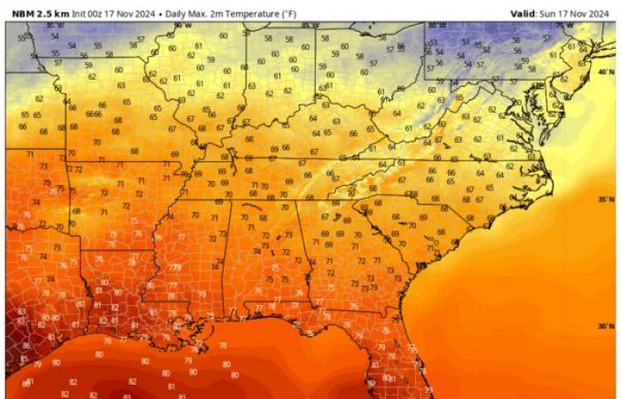
Sunday Highs
FOR YOUR SUNDAY: Another great day is in store for Alabama with more sunshine and temperatures running some 8-10 degrees above normal. That will equate to highs ranging from 68F up North to 75F around Montgomery. That is after some fairly normal morning readings in the 40s. There could be a little patchy fog overnight tonight, but otherwise skies will be fair with lows in the upper 40s to lower 50s.
CHANGES TO START THE WEEK: Monday stays mostly sunny, but clouds will increase by late afternoon into the overnight as that next storm system heads our way. Winds will also become gusty as a strong low pressure system moves from near the Red River into Kansas. That low will be equivalent to a minimal hurricane with a barometric reading around 980-985 millibars. Winds will gust as high as 60 mph ahead of the low over the Midwest. We won’t see those kinds of gusts here, more like 25 mph by Monday evening. And get used to that. Winds will remain gusty all the way through Friday across Alabama. Rain will push into Southwest Alabama Monday night with a few showers possible across Central Alabama by morning. Highs on Monday will be in the lower and middle 70s. Lows Monday night will stay in the 60s.
DAMP TUESDAY: I was hoping to call for a wet Tuesday, and I think can for South Alabama, but Central Alabama may be cut off from the better moisture as a surface low develops along the Gulf Coast. A quarter to one half inch of rain looks like it might be the best we manage from this system. Coastal sections could get a LOT more, as in 4-6 inches as some of the deep moisture from Sara gets entrained northward. There could be a little thunder involved.
WINDY WEDNESDAY: The rain should move out early Wednesday morning with clearing skies during the first part of the day. It will be cooler, with highs managing to reach the 60s. Winds will continue to gust to 25 mph at throughout the day and even into the overnight.
BIG COOLDOWN TO END THE WEEK: Sunny skies will continue for Thursday into the weekend. But the mercury will be going south. Highs on Thursday, Friday, and Saturday will likely not get out of the 50s. Lows will be rivalling the coldest since last April, with 30s each morning. Birmingham has recorded a 38F on 10/16 this year. You would have to go back to 4/6 when it was 36F for colder. We are calling for 36F Friday and Saturday mornings.
VOODOO TERRITORY: Thanksgiving is now in our sights. The bad weather in the busy travel days leading up to Thanksgiving look like they will be over the Western United States. It looks like our Turkey Day may be wet, and our Black Friday wetter. The rain looks to move out for the Iron Bowl with cooler conditions.
SARA:
Go now
Don’t look back
We’ve drawn the line
Move on
It’s no good to go back in time
Sara…Sara…your storms are disorganized….
(apologies to Starship!)
Tropical Storm Sara continues to weaken as it moves west-northwest toward Belize. With maximum sustained winds near 40 mph and a disorganized structure, Sara is expected to make landfall today along the Belize coast before dissipating over the southern Yucatan by early Monday. Despite its weakening intensity, Sara poses a significant threat of catastrophic flash flooding and mudslides, particularly in northern Honduras, Belize, eastern Guatemala, and parts of Mexico’s Quintana Roo state. Tropical storm warnings remain in effect for these areas.
SEVERE WEATHER OUTLOOK
Severe weather is possible today across West Central Texas, including places like Wichita Falls, Abilene, and Midland. Severe thunderstorms are expected to develop across parts of western, central, and northwest Texas tonight into early Monday morning. These storms could bring a risk of damaging gusts and possibly a few tornadoes, especially as a squall line strengthens. Severe thunderstorms are expected across parts of northern Texas and southern Oklahoma on Monday morning, posing a risk of isolated damaging gusts and perhaps a tornado in places like Lawton, Duncan, and Dallas/Ft. Worth. By the afternoon and evening, a marginal risk for severe gusts will extend from the eastern southern Plains into the Ozarks and lower Mississippi Valley, depending on the persistence of the squall line.
NATIONAL NOTES
The big storm in the west will bring a variety of impacts to the middle of the country in the week ahead including storms, rain, wintry weather and strong winds. This morning, winter storm warnings and winter weather advisories are in effect across the Cascades and the northern Rockies. 10-18 inches of snow could fall above 4000′ along the western slopes of some of the Cascades, with 1-6″ in the valleys. Coastal flood advisories and warnings are in effect along the Washington and Oregon coasts. Across the southern Plains, flood watches are in effect in anticipation of heavy rains over North Texas and Oklahoma. The fire weather threat over the northeastern United States will go back to critical over the next three days. Some relief is due later in the week.
BEACH FORECAST
Today will be dry along the beautiful beaches of Alabama and Northwest Florida. A few showers are possible on Monday and rain will become likely by Monday night. A steady rain is likely on Tuesday as some of the moisture from Sara is entrained into the system moving along the northern Gulf Coast. Then, there will be an extended dry period through the middle of Thanksgiving Week with showers returning about the time the turkey is ready. Visit our Beach Forecast Center to get the latest weather and rip current forecasts for beaches from Fort Morgan to Panama City. This page allows you to select forecasts tailored to your destination, ensuring you have the most accurate and relevant information for your beach plans. Stay informed and safe on your coastal getaway!
THIS WEEK ON WEATHERBRAINS
Monday night, we will be talking with a couple of folks involved with an Oklahoma Severe Weather Research Field Project involving drones including Steve Piltz from the NWS Tulsa and Dr, Jamey Jacob from Oklahoma State. Check out the show at www.WeatherBrains.com. You can also subscribe on iTunes. You can watch the show live on our new YouTube channel for the show and you can see the live show on the James Spann 24×7 weather channel on cable or directly over the air on the dot 2 feed.
ON THIS DATE IN 1957
A tornado northwest of Jasper near Saragossa and Manchester killed four people, including three from one family in a new ranch home. More on the blog in a 9 a.m. weather history post. Follow my weather history tweets on Twitter. I am @wxhistorian at Twitter.com.
Category: Alabama’s Weather, ALL POSTS, Severe Weather, Tropical


