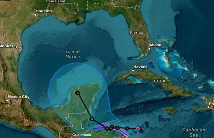
Tropical Depression Nineteen formed in the Caribbean early Thursday with the National Hurricane Center forecasting it to grow into Tropical Storm Sara. Long-term forecast models show it could enter the Gulf of Mexico and then turn toward Florida’s Gulf Coast.
As of the NHC’s 7 a.m. advisory, TD 19 was located about 250 miles east of Isla Guanaja, Honduras and 90 miles east-northeast of Cabo Gracias a Dios on the Nicaragua/Honduras border moving west at 15 mph with maximum sustained winds of 35 mph.
A hurricane watch is in effect for Punta Castilla, Honduras to the Honduras/Nicaragua border, a tropical storm warning from Punta Sal, Honduras to the Honduras/Nicaragua border and the Bay Islands of Honduras while a tropical storm watch is in place for the Honduras/Nicaragua border to Puerto Cabezas, Nicaragua.
“The depression is expected to stall and meander near the north coast of Honduras late Friday and through the weekend,” said NHC hurricane specialist Andrew Hagen. “The depression is forecast to become a tropical storm later today and continue strengthening, if it remains over water.”
The NHC said 10 to 20 inches with some areas would get 30 inches of rain over northern Honduras. Up to 15 inches could also fall across the rest of Honduras, Belize, El Salvador, eastern Guatemala and western Nicaragua.
The NHC only forecasts out five days with its projected path, and that has it venturing over Mexico’s Yucatan peninsula as a tropical storm and entering the Gulf of Mexico.
“It is too soon to determine what impacts the system could bring to portions of the eastern Gulf of Mexico, including Florida, the Florida Keys, and Cuba during the middle portion of next week,” Hagen said. “Residents in these areas should regularly monitor updates to the
forecast.”
Long-term forecast models show it getting sucked back to the east once in the Gulf of Mexico.
The interaction with land, though, could mean it doesn’t gather enough strength to grow into a hurricane, but models still show it potentially making a Florida landfall.
“A ridge aloft across Florida will gradually shift east early next week, allowing this system to lift northward into the Gulf of Mexico into Tuesday/Tuesday night,” said National Weather Service Melbourne lead meteorologist Derrick Weitlich.
He notes the models runs as of Thursday morning show a weaker system in the Gulf of Mexico.
“However, there remains some uncertainty on exact track, and how much land interaction will occur, which could lead to overall intensity
differences after it emerges into the Gulf,” he said. “It is still too early to say what impacts, if any, may result across east central Florida from this system toward the middle of next week.”
If it does turn and strike Florida, it could become the fourth named storm to hit the state’s Gulf Coast this hurricane season following hurricanes Debby, Helene and Milton.
The 2024 Atlantic hurricane season has had 19 tracked systems including 17 named storms, 11 of which became hurricanes. Five of those grew into major hurricanes of Category 3 strength or stronger.
The season runs from June 1-Nov. 30.
Originally Published: November 14, 2024 at 6:37 AM EST


