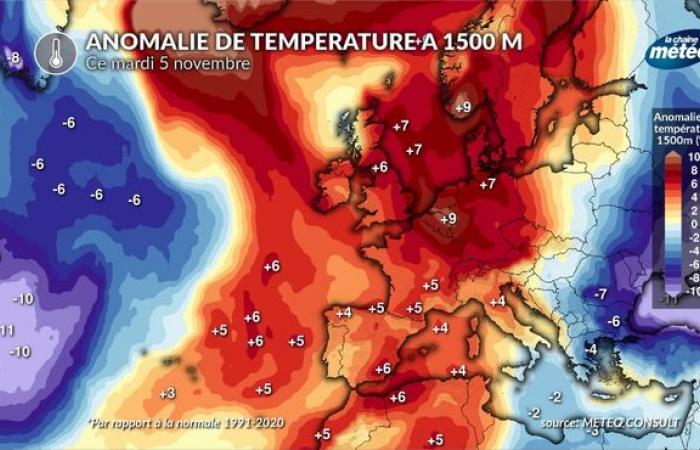
While snow fell from 1200 m altitude on our massifs last year at the same time with a good cool and humid northwest flow, the situation is radically opposite this month of November with an anticyclone stuck on the Western Europe accompanied by a remarkably mild air mass for the season. The combination of dry and mild weather does not allow the snow that fell at the beginning of October to persist. And our forecasts are not optimistic for the coming weeks.
A very snow-deficient start to the season
Serious lack of snow above Val d'Isère © capture webcam
There is a very poor snowfall for the beginning of November in the Alps and the Pyrenees. The early bursts of snow in October have melted and snow cover is almost non-existent below 3000 m except on the North face around 2600 to 2700 m. In the Southern Alps, these would be the most deficit values since 2006 (Col d'Agnel station in Queyras). We observe the same situation in the Pyrenees.
Note that from 3000 m altitude, the snow is good from there due to the heavy accumulations of snow that fell in September/October. But this snow is not renewed due to the persistence of dry anticyclonic weather. This type of weather will not change in the next 10 days and could characterize the overall trend in November and December.
Softness and dry weather: the worst combination for snow in the mountains
Following on from this year setting records for rainfall in France, the first snow fell early in September and October, giving hope for a very white start to the season. But the wet recurrence stopped at the end of October with the return of a powerful anticyclone which, since then, has not let go of Western Europe.
It is not uncommon for the first heavy snows to melt during the fall before new falls resume later. But in this first decade of November, the only sub-layers allowing the winter snow coat to grip were only formed above 3000 m. There is nothing left below, and above all, our forecasts do not envisage a radical change in weather type before at least November 20.
These high pressures have two major disadvantages: the persistence of dry weather (neither rain nor snow) and very mild weather at high altitudewhich melted the October snow below 2600m altitude.
The snow forecast is pessimistic for the coming weeks
An exceptionally mild air mass at altitude © The Weather Channel
At this time of year, it is obviously not too late to build up a snow cover which would reassure those involved in winter sports and tourism, who see the month of December and the ski season quickly approaching.
But to date, apart from the lack of snow observed, the forecasts are not encouraging in this sense. The current anticyclonic blockage looks set to last until around November 15, and possibly beyond, with air becoming colder but still dry. There is hope around mid-November for the southern Alps: as is often the case with continental anticyclonic blockages, depressions form in the Mediterranean. One of them could affect the south-east of France, which would cause rain in the plains and snow at altitude. This prospect seems quite credible to us in this configuration, but it will have to be confirmed.
For the rest, maritime polar air would have to come down from the northwest to cover our other massifs with snow. This could also be the case after November 20 as well.
More generally, our seasonal forecasts in any case envisage a month of November and December with a deficit in precipitation (rain and snow) under the effect of the predominant high pressures. But, as we can see, temporary bursts of snow can still occur and occur just before the school holidays.


