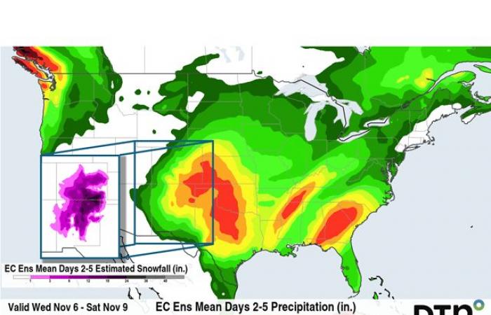
Currently, models are disjointed on where that low will be positioned as it moves through the region. The European EPS ensemble model is about 100 miles west of where the American GEFS model believes it will track. And that means big differences in the forecast.
The EPS draws more of the moisture westward into the mountains, which aids in lifting the air and producing heavy rain, some thunderstorms, and heavy snow into the southwestern Plains. Total liquid-equivalent amounts of 1.5 to 2.5 inches are in the forecast across southeast Colorado and northeastern New Mexico arcing through southwestern Kansas down into north-central Texas. In contrast, the GEFS reduces the amounts down to 1 to 1.75 inches. Though roughly the same areas are shown in the bull’s-eye of the two models, the GEFS is a tad farther to the east.
That significantly changes the forecast for snow from the models as well. The EPS is intent on providing significant areas of eastern Colorado and northern New Mexico with more than 6 inches of snowfall, with potential for some of these areas to get more than a foot of heavy, wet snow. The EPS is producing amounts generally under 6 inches across these same areas.
However, either way, some areas of the southwestern Plains — which are in drought and only got light rainfall from some of the recent storms — will get much more precipitation. This will help ease drought concerns and boost moisture for winter wheat areas that still have poor conditions compared to last year at this time. Areas farther east across Oklahoma and Kansas that have already seen heavy rainfall are due for more. Flooding could reoccur, especially if strong thunderstorms are involved.
One more layer of uncertainty comes in the form of tropical moisture. Tropical Storm Rafael, which as of early Tuesday morning is in the Caribbean near Jamaica, will cross Cuba and head northwest into the Gulf of Mexico by early Thursday, likely as a hurricane. Though the current forecast is for it to weaken as it moves deeper into the northern Gulf of Mexico, in part because of the upper-level low, the warm Gulf waters may be able to combat that somewhat. This could lead to even more moisture being absorbed into the system for the end of the week.
This could then spread heavier rainfall through more of the Plains and Midwest. Models are mixed on that prospect as the eastern GEFS gets closer to Rafael and pulls it northward, while the western EPS doesn’t have nearly the same pull, instead allowing the tropical system to continue west toward Mexico.
With so much uncertainty in the above features, expect the forecast to change during the next couple of days, even during the event. It already has during the last two days.
To find more weather conditions and your local forecast from DTN, head over to https://www.dtnpf.com/…
John Baranick can be reached at [email protected]
(c) Copyright 2024 DTN, LLC. All rights reserved.


