WEATHER – The worst of the heavy rain associated with Low Kirk has passed. This Thursday, October 10 in the morning, they are gradually weakening, crossing Île-de-France towards the northeast. Despite everything, Seine-et-Marne still remains on alert for red floods.
Storm Kirk: National Assembly building flooded due to heavy rain
In addition to this department, Météo-France also maintained six departments on orange flood alert, according to its latest bulletin published at 6 a.m. However, orange wind vigilance has been lifted in all the departments concerned (Territoire de Belfort, Haute-Saône, Doubs), as well as flood vigilance in the Alpes-Maritimes.
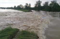
A risk of flooding “strong to exceptional” on the Grand Morin River, a sub-tributary of the Seine, justified the placement of Seine-et-Marne on red alert, according to Vigicrues. In Pommeuse, a town crossed by the river, the town hall remained open all night to welcome possible victims, indicated The Parisian.
In total, the exceptional flood of the Grand Morin reached a level of 3.3 meters. This is more than the 3.06 meters of that of September, but less than that of June 2016, at 3.42 meters, recalls La Chaîne Météo.
During the night, the A5B was closed in the department near Évry-Grégy sur Yerres in the Brie-Melun direction. School transport is suspended there this Thursday.
Further south, without a link being officially made with Kirk for the moment, a boater died off the coast of Sète and another is in absolute emergency after the strong swell shaking the coasts of Hérault caused capsize three boats, announced the prefecture of this department.
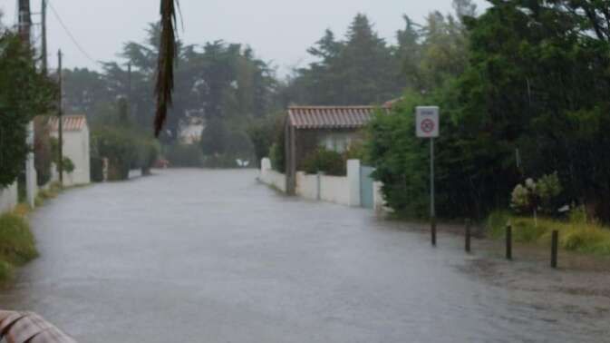
In Noirmoutier-en-l’Île, in Vendée, the hospital center was affected by a flood. Many roads were flooded in many sectors of the department. Firefighters carried out more than 130 interventions.
The heavy rainfall also caused flooding of the A11 motorway towards Paris in the town of Chartres, in Eure-et-Loir, leading to a cutting of this road, indicated Bison Futé.
In the Loire" rel="tag">Pays de la Loire, “heavy rain led to flooding on the tracks” between Saint-Nazaire and Le Croisic, Nantes and Pornic as well as between Nantes and Saint-Gilles, interrupting rail traffic in places. In Loire-Atlantique, 22 roads were completely or partially cut, according to the departmental council. On the Nantes ring road, one of the right lanes was neutralized and completely flooded.
In the capital, 70 mm of rain fell on Wednesday, making it the wettest autumn day since 1920, according to Météo-Express. Metro stations found themselves with their feet in the water, like at Saint-Lazare station. Even the National Assembly did not escape it, as MP François Ruffin shared on social networks.
Strong gale in New Aquitaine
Furthermore, more than 67,000 customers were deprived of electricity on Wednesday evening, mainly in the southwest, announced Enedis, the distribution network manager. This Thursday morning, 18,000 customers were still without electricity in Alsace and Franche-Comté.
The equivalent of a month of rain had been forecast for Wednesday alone on a route from Vendée to Champagne-Ardenne.
According to the Minister for Transport François Durovray, the difficulties remained at the end of the day on Wednesday “limited”including “a few planes diverted”. On the rail, he mentioned the possibility “of lying trees” or “slope collapses” and arrangements made “so that before the opening of the service” this Thursday, “all checks are carried out and obviously the safety of users is ensured”.
The SNCF carried out localized traffic interruptions at 7 p.m. on Wednesday in order to guarantee the safety of travelers and staff, particularly in New Aquitaine, Pays de la Loire and Rhône-Alpes. As a precaution, the SNCF had scheduled a total interruption of traffic on several routes on Wednesday, notably between Dax (Landes) and Tarbes (Hautes-Pyrénées), Bayonne and Hendaye (Pyrénées-Atlantiques) or even Saintes and Royan (Charente-Maritime).
This Thursday morning, traffic was notably interrupted between Besançon and Belfort, and between Dole and Besançon, due to falling trees on the tracks.
In New Aquitaine, a strong gale occurred, particularly on the western peaks of the Pyrenees.
According to Météo France, gusts of 211 km/h were even recorded in the area of the Iraty ski resort in the Pyrénées-Atlantiques.
Also see on Le HuffPost :
Hurricane Milton in Florida triggers an avalanche of tornadoes before its passage
Storm Kirk, Hurricane Milton… How warmer oceans cause more extreme weather events