Par
Timothée L’Angevin
Published on
Oct 6, 2024 at 6:18 p.m.
See my news
Follow News
It’s a Category 4 monster. And it’s heading straight for us. L’ouragan Kirk, right now in the middle of the Atlantic, should hit France on Wednesday October 9, 2024.
If it will lose intensity and lose its hurricane status before reaching our coasts, it is already panicking the different weather models. According to several models, it could cause “a major storm” on France, points nearactu.fr meteorologist Guillaume Séchet (founder of the Météo-villes site).
Vendée and Charente-Maritime on the front line
Hurricane Kirk formed off the coast of Senegal on September 27. It quickly headed north, driven by the Gulf Stream (warm ocean current from the North Atlantic), instead of heading towards the Antilles or the American coast, as most phenomena of this type do.
“This Sunday (October 6), he is 3,000 km southwest of France, very east of Bermuda, and above all very north of the West Indian arc,” insists Guillaume Séchet. “Depending on the trajectory it is taking, it could hit the French Atlantic coast, Vendée and Charente-Maritime, before rushing inland towards Lorraine and Belgium. »
According to the different weather models, the Pays de la Loire, Nouvelle Aquitaine, the Centre, Île-de-France, Hauts-de-France and the Grand Est will be the most affected, but Brittany, Normandy and even regions further south should not be spared.
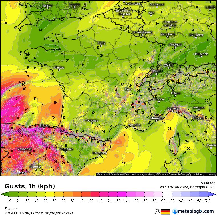
Below, the scenario of the German Icon model (corroborated by the French Arpege model, which even evokes gusts of 160 km/h):
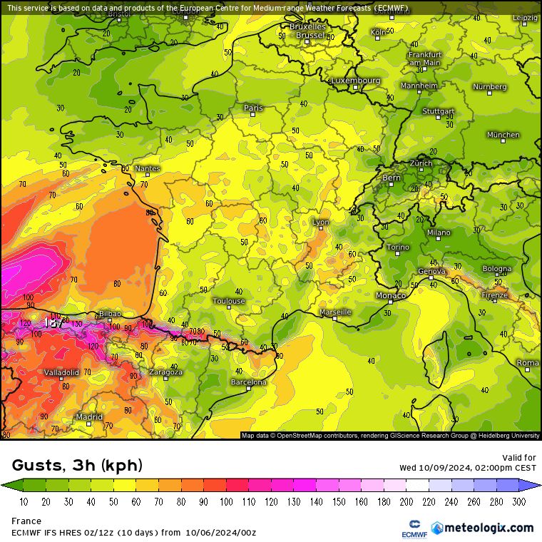
However, other models are more measured, such as the ECMWF:
Gusts of up to 150 km/h?
According to the meteorologist, it should hit France on Wednesday October 9, in the middle of the day.
It’s still too early to make any predictions, but the scenarios go in all directions. According to the most pessimistic, we could have gusts of 120-130 km/h inland, and up to 150 km/h on the coasts. With fairly rare tropical characteristics, Hurricane Kirk can cause a major storm in France.
Storm or hurricane, what’s the difference?
As a reminder, a storm is considered such when the average wind is greater than 90 km/h. For a hurricane, the wind must exceed 118 km/h.
But in Europe, we do not speak of a hurricane, rather of a “hurricane-like storm”, meteorologist Yann Amice told us in a previous article.
We remember that of 1987, Lothar and Martin at the end of 1999, or even Xynthia in 2010.
These storms are considered extratropical cyclones (or extratropical depressions). Some are of the weather bomb type, that is to say mid-latitude depressions whose central pressure drops sharply within a few hours.
The 1987 hurricane in memories
Could this configuration recall the storm of October 1987? The latter ravaged Brittany and Cotentin, killing 15 people and causing very heavy damage. The winds were so strong that this phenomenon was named “Hurricane of 1987”. Are we going to experience a similar situation again?
“Difficult to say,” replies Guillaume Séchet. It is also possible that we will not reach the storm stage and that we will simply have a strong gale. »
This phenomenon should, however, be short-lived and should evacuate to the north-east of France during the night from Wednesday to Thursday.
Follow all the news from your favorite cities and media by subscribing to Mon Actu.