
Light jacket needed for the morning with seasonable highs
Updated: 6:03 AM CDT Oct 8, 2024
APPEALED THAT RULING. >> WE HAVE COOLER, DRIER AIR ACROSS THE DEEP SOUTH THIS MORNING. HIGH PRESSURE, BRINGING THAT COOL AIR FROM CHICAGO AND SAINT LOUIS DOWN TO THE STATE. WE’RE CURRENTLY SITTING IN THE 50S, UPPER 40S THIS MORNING IN NASHVILLE AND CHICAGO. CLOSER TO THE UPPER 30S. MUCH OF THE DEEP SOUTH COOLER THAN WHERE WE WERE AT THIS POINT YESTERDAY FOR CENTRAL MISSISSIPPI. WE’RE STUCK IN THE 50S. I DON’T THINK A LOT OF PEOPLE ARE GOING TO COMPLAIN, BUT IT IS GOING TO BE ONE OF THOSE MORNINGS WHERE YOU WILL NEED THAT LIGHT JACKET AS YOU HEAD OUT THE DOOR. WE HAVEN’T HAD TEMPERATURES THIS COOL IN WHAT FEELS LIKE A WHILE, BUT BACK IN SEPTEMBER, THERE WERE A COUPLE OF DAYS WHERE WE HAD TEMPERATURES WAKING UP IN THE UPPER 50S, AND I KNOW I WAS ONE OF THOSE PEOPLE THAT NEEDED THAT LIGHT JACKET, SO YOU’RE GOING TO NEED IT AGAIN. TODAY. WE’RE LOOKING AT HIGHS CLIMBING BACK TO THE UPPER 70S, LOW 80S, A LOT MORE SEASONABLE THIS AFTERNOON. WALL TO WALL SUNSHINE AND COMFORTABLE CONDITIONS EXPECTED TODAY INTO THE EVENING. WE DROP BACK INTO THE 60S AFTER DARK MID 50S, LIKELY REGION WIDE TOMORROW MORNING AND THEN HIGHS IN THE AFTERNOON. COULD BE SLIGHTLY WARMER MID 80S FOR PARTS OF THE STATE. AND THIS REALLY IS GOING TO BE THE TREND OVER THE NEXT COUPLE OF DAYS TO WHERE WE’RE LOOKING AT MID 80S THROUGH THE REST OF THE WEEK, POSSIBLY SEEING UPPER 80S BY THE WEEKEND. AND THEN WE HAVE THE POSSIBILITY OF ANOTHER COLD FRONT GOING INTO NEXT WEEK. ONE OF THE REASONS WHY WE HAVE THESE TEMPERATURES COOLER THAN AVERAGE IN THE MORNING AND COMFORTABLE IN THE AFTERNOON IS BECAUSE OF THE AIR ALOFT. IT’S A LOT COOLER ALOFT. AND SO THIS IS ALLOWING THOSE CRISP, COOL MORNINGS AND WARM AND COMFORTABLE AFTERNOONS THAT HIGH PRESSURE HELPING US OUT. THE COLD FRONT’S GOING TO REINFORCE THAT GOING INTO NEXT WEEK. ALL RIGHT, MILTON WEAKENING A LITTLE BIT OVERNIGHT. BUT STILL ABOUT TWO MILE AN HOUR AWAY FROM THAT CATEGORY FIVE STATUS. THIS WILL REINTENSIFY TO A CATEGORY FIVE STATUS LATER TODAY. ONE OF THE BIG CONCERNS WITH THIS IS GOING TO BE THE THREAT FOR STORM SURGE. WE’RE LOOKING AT ANYWHERE BETWEEN 9 TO 12, EVEN 15 FOOT STORM SURGE FROM TAMPA DOWN TOWARDS PARTS OF CAPE CORAL. AS WE HEAD INTO WEDNESDAY AFTERNOON, THE STORM DOES LOOK TO WEAKEN, BUT THE QUESTION IS TO WHAT EXTENT AND HOW QUICKLY THIS IS STILL GOING TO BE A HISTORIC STORM FOR THE STATE OF FLORIDA. AND WE’RE NOT ONLY LOOKING AT TORNADO THREATS ALONG THOSE OUTER BANDS, WE’RE LOOKING AT STORM SURGE ON THE SOUTHERN SIDE AND THE EASTERN SIDE OF THE STORM. AND THEN TO THE NORTH, WE’RE LOOKING AT FLOOD THREATS FROM GAINESVILLE TO JACKSONVILLE AS THE STORM MOVES ACROSS, IT’S LIKELY BY THURSDAY AFTERNOON THIS STILL COULD BE CLASSIFIED AS A HURRICANE AS IT MOVES INTO THE ATLANTIC. RAINFALL TOTALS ARE GOING TO BE GREATEST AGAIN TO THE NORTHERN PART OF THE STORM. FROM TAMPA TO DAYTONA BEACH, UP TOWARDS JACKSONVILLE, FLORIDA, WAVE HEIGHTS ARE LOOKING TO BE ANYWHERE BETWEEN 3 TO 6FT TOWARDS TAMPA. THAT COULD BE THEIR BEST SCENARIO. IF THE EYE GOES OVER TAMPA, IF THE EYE IS TO THE NORTH, IT’S GOING TO BE ON THE DIRTY SIDE. AND WE’RE LOOKING AT STORM SURGE ANYWHERE BETWEEN 9 TO 12FT. LIKE WHAT VENICE BEACH IN SARASOTA, FLORIDA COULD POTENTIALLY BE DEALING WITH. SO NOT A GOOD SITUATION FOR FLORIDA WHATSOEVER. WE’LL KEEP BRINGING YOU GUYS UPDATES ON THIS STORM. THANKFULLY FOR US, IT IS A QUIET WEEK. NOTHING BUT SUNSHINE AGAIN. MAYBE A SLIGHT WARM UP AS WE HEAD INTO THE WEEKEND, BUT OUR NEXT FRONT ARRIVES MONDAY AND THAT WIL
Light jacket needed for the morning with seasonable highs
Updated: 6:03 AM CDT Oct 8, 2024
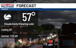
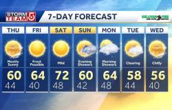
It’s a cooler Tuesday morning with lows in the 50s. Highs will reach the upper 70s to low 80s by the afternoon with clear blue skies. Temperatures will fall to the 60s after sunset and return to the 50s Wednesday morning. Highs Wednesday will reach the mid 80s with wall to wall sunshine.This pattern continues for the rest of the week and the weekend. Lows will remain in the 50s with highs in the mid to low 80s. A slight warmup by the weekend could get highs closer to the upper 80s. Another front could arrive Monday next week, dropping highs back to the upper 70s and low 80s. Tropics UpdateMilton defied all odds Monday, strengthening from a tropical storm to a category 5 hurricane in 24 hours and one of the fastest pressure drops of all times. The lowest pressure Milton dropped to was less than Katrina’s from 2005. It is now in the top 5 strongest hurricanes for the Atlantic basin on record. The storm, while small, only had an eye of just under 4 miles Monday evening. Now that it has undergone an eyewall replacement cycle, the storm is expected to get bigger prior to landfall. Flooding will be greatest north of Tampa with some areas reaching up to a foot of rain. On the northeast side of the storm, storm surge will be a major concern. If the center of the storm moves north of Tampa, this will be one of the most catastrophic surges into the bay. However, if the center moves over, or just south, of Tampa, the storm could drain water out of Tampa Bay and slingshot its south towards Fort Myers. This could create historic surge for Fort Myers, similar to what we saw with Ian in 2022.
It’s a cooler Tuesday morning with lows in the 50s. Highs will reach the upper 70s to low 80s by the afternoon with clear blue skies. Temperatures will fall to the 60s after sunset and return to the 50s Wednesday morning. Highs Wednesday will reach the mid 80s with wall to wall sunshine.
This pattern continues for the rest of the week and the weekend. Lows will remain in the 50s with highs in the mid to low 80s. A slight warmup by the weekend could get highs closer to the upper 80s. Another front could arrive Monday next week, dropping highs back to the upper 70s and low 80s.
Tropics Update
Milton defied all odds Monday, strengthening from a tropical storm to a category 5 hurricane in 24 hours and one of the fastest pressure drops of all times. The lowest pressure Milton dropped to was less than Katrina’s from 2005. It is now in the top 5 strongest hurricanes for the Atlantic basin on record. The storm, while small, only had an eye of just under 4 miles Monday evening. Now that it has undergone an eyewall replacement cycle, the storm is expected to get bigger prior to landfall.
Flooding will be greatest north of Tampa with some areas reaching up to a foot of rain. On the northeast side of the storm, storm surge will be a major concern. If the center of the storm moves north of Tampa, this will be one of the most catastrophic surges into the bay. However, if the center moves over, or just south, of Tampa, the storm could drain water out of Tampa Bay and slingshot its south towards Fort Myers. This could create historic surge for Fort Myers, similar to what we saw with Ian in 2022.