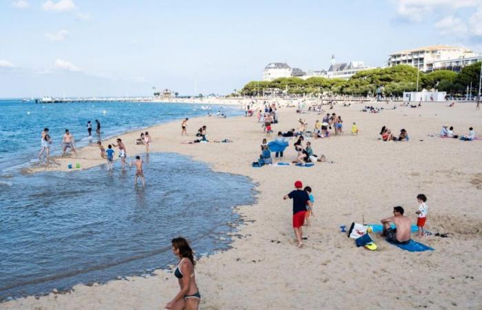
Venice, Barcelona, Easter Island, Porquerolles Island, Mont Blanc. What do these emblematic places have in common? They are visited too much. The influx of tourists is no longer bearable for local populations and threatens the balance of natural environments so that local authorities are forced to take measures that are often unpopular: establishing quotas, paying tolls, banning areas to certain times of the day or during the most popular seasons. Thus, the term “overtourism” emerged in 2017 but was especially deployed in 2022, after the Covid-19 pandemic and the recovery that followed it.
But how can we really measure the phenomenon? At a conference organized in 2023 by the Institute of Geography and Sustainability at the University of Lausanne (Switzerland), participants agreed that “return to the main principles of the historical sociology of quantification”that is to say measuring the extent of the phenomenon. Not easy. Current tools are unsatisfactory. The data comes from indices: hotel and para-hotel attendance, surveys of local populations, tourism stakeholders, communities, satisfaction surveys. Protected areas also use “eco-cameras” to monitor the flow of hikers around the most protected natural sites. These tools are imprecise and the methods used are not harmonized.
Smartphone GPS allows you to track an individual
This is why the technique developed by the start-up “Citiprofile” is revolutionizing the sector. “Thanks to the GPS of your smartphones, we count moving points on a given territory, explains Arnaud Trousset, geographer co-founder of Citiprofile with Olivier Thomine, engineer-researcher in high performance computing. More precisely, we anonymously analyze the number of people and vehicles and their movements in a given territory..
The method is relatively simple, but requires a lot of computing power. Citiprofile purchases tracking batches of 5,000 to 10,000 free or paid applications present on smartphones which give the location of the device, but also give an idea of the nationality and place of residence. “Thus, if a point moves over a small area and returns to the same place every day for a period of several months, it is likely that it is a resident and not a tourist. explains Esprit Gibassier, data journalist within this company created in 2022. The privacy of individuals is not violated since the points are anonymized and this first step is therefore endorsed by the general data protection regulations (GDPR).
Read alsoFaced with overtourism, Pompeii limits the number of visitors
A superposition of layers of information
“The second step consists of superimposing these points on the different layers giving geographical information on a territory.continues Esprit Gibassier. IGN topographical maps, demarcations of protected areas and administrative boundaries, town planning, sociological composition of neighborhoods, INSEE data, mobility surveys and satellite images such as Google Earth”. Each request uses its particular set of geographic maps. We thus obtain highly precise movement and mass attendance data from which lessons can be drawn for better space management.
The service is currently used in three sectors. That of tourism is the most obvious. The method makes it possible to highlight the most frequented places, which makes it possible to guide the management of spaces where conflicts of use are the greatest. But it is also useful in terms of town planning since we obtain more precise and rapid knowledge of the flow of people in a territory (global mobility studies are carried out every ten years). Finally, better knowledge of these flows is sought after by the commercial sector in search of the best locations for setting up businesses or activities.
Read alsoHow to travel climate-friendly
Here are four examples:
- Attendance at Perthuis d’Antioche
Between the Île de Ré and the Île d'Oléron with the Île d'Aix in its center, the Perthuis d'Antioche sees a high number of pleasure crafts in the summer. If the movements of the maritime shuttles between La Rochelle and the three islands are well known due to the equipment of the ships with an automatic identification system, where do the motor and sail boats which are less than 12 meters go? GPS tracking makes it possible to reconstruct the chosen routes. And to note that the Fort Boyard tower is the most popular sea trip. Thanks to the speed of movement, the technique also makes it possible to determine whether a person is on foot or using a bicycle or a car. Click on the image to enlarge it
- Attendance at the Arcachon Basin
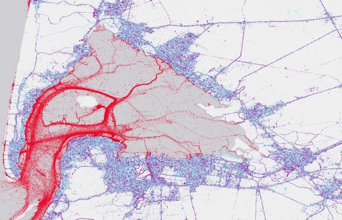
The Arcachon basin is one of the busiest sites in summer on the Aquitaine coast. How do summer visitors travel between using their own means of transport and using professional sea trips? What are the most popular sites? Where do visitors come from? GPS monitoring shows a high number of visitors to the beaches and surroundings of the town of Arcachon and Cap Ferret and significant visits to the Banc d'Arguin, a vast expanse of sand at the foot of the Pilat dune which is also a site of significant reproduction of seabirds. Click on the image to enlarge it
- The Camargue and the plover

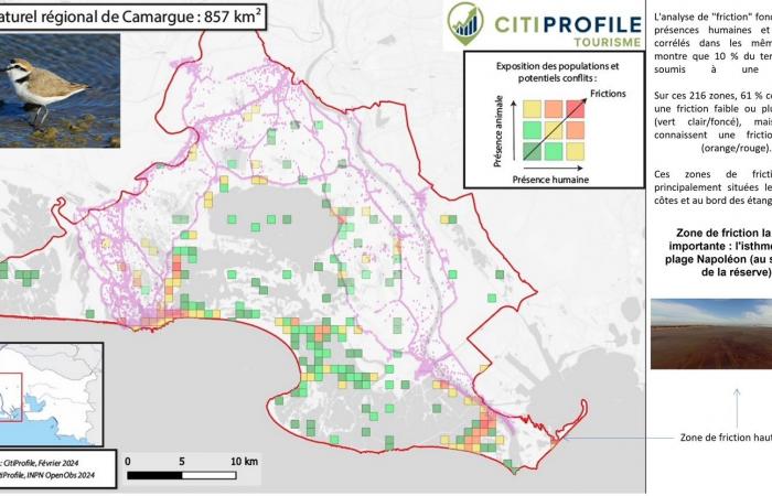
At the request of the Bird Protection League (LPO), Citiprofile cross-referenced tourist numbers on Camargue beaches with the map of breeding sites for the Ring-necked Plover, an endangered bird that lays its eggs directly on the sand. . The red dots represent crucial places for the species where humans (and their dogs) are most numerous. The LPO has thus identified the places where it will need to strengthen its protections. Click on the image to enlarge it
- Bonifacio and the Posidonia herbaria
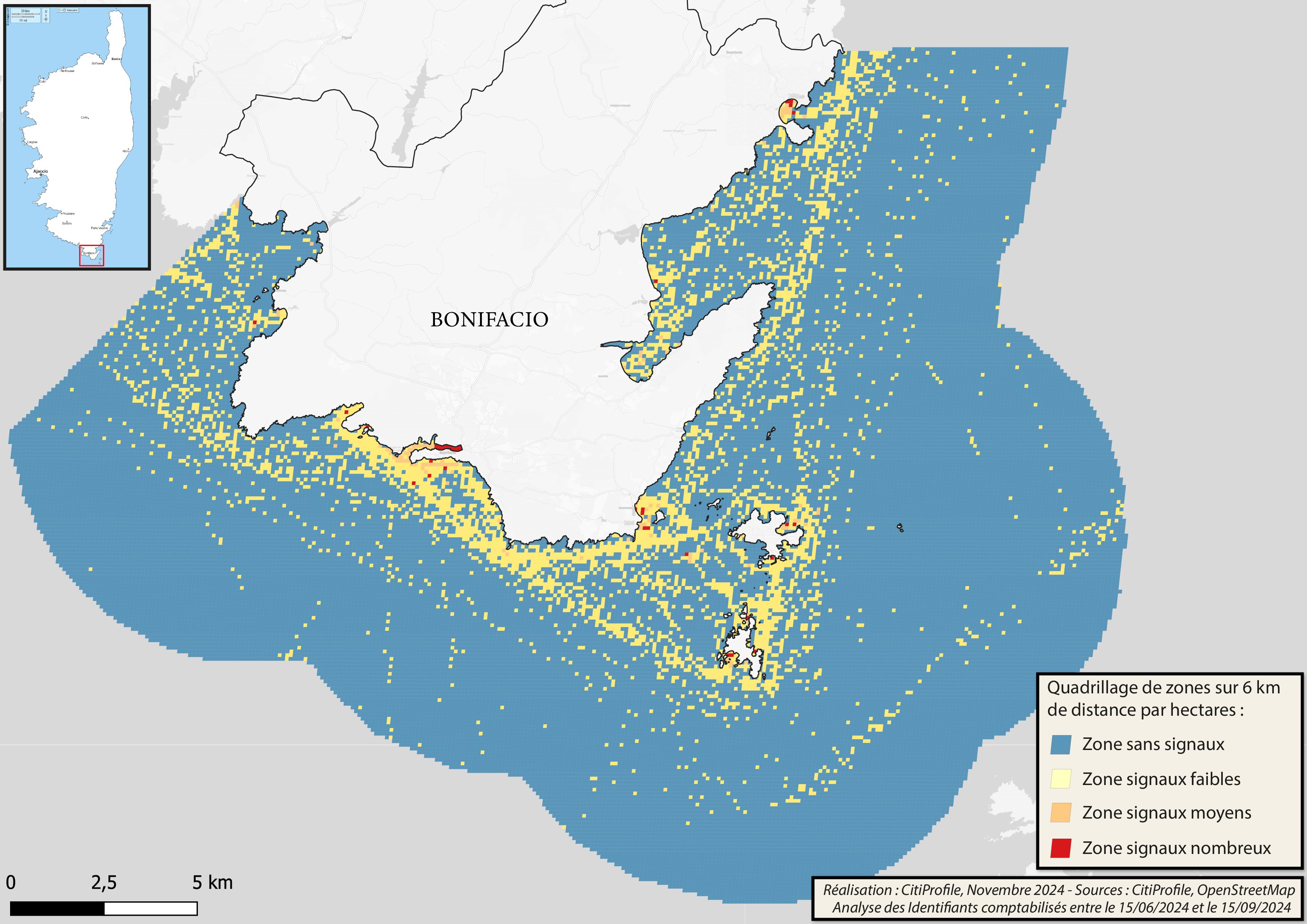
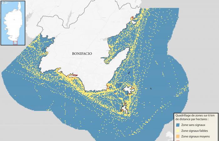
At the request of the Rhône-Mediterranean-Corsica Water Agency, Citiprofile used GPS data from boat owners to characterize travel habits as well as anchorages in Corsica, here at the tip of Bonifacio. These data were cross-referenced with the mapping of Posidonia herbaria, a protected Mediterranean plant. Managers can thus intervene in places where mooring habits correspond with seagrass beds, in order to prohibit these places and force boaters to frequent sandy areas without risk of damaging the plant. Click on the image to enlarge it

