Elected officials and technicians from local authorities in Charente-Maritime have just attended an information meeting on a new mapping tool developed by the IGN. The entire department is now accessible in 3D for municipalities.
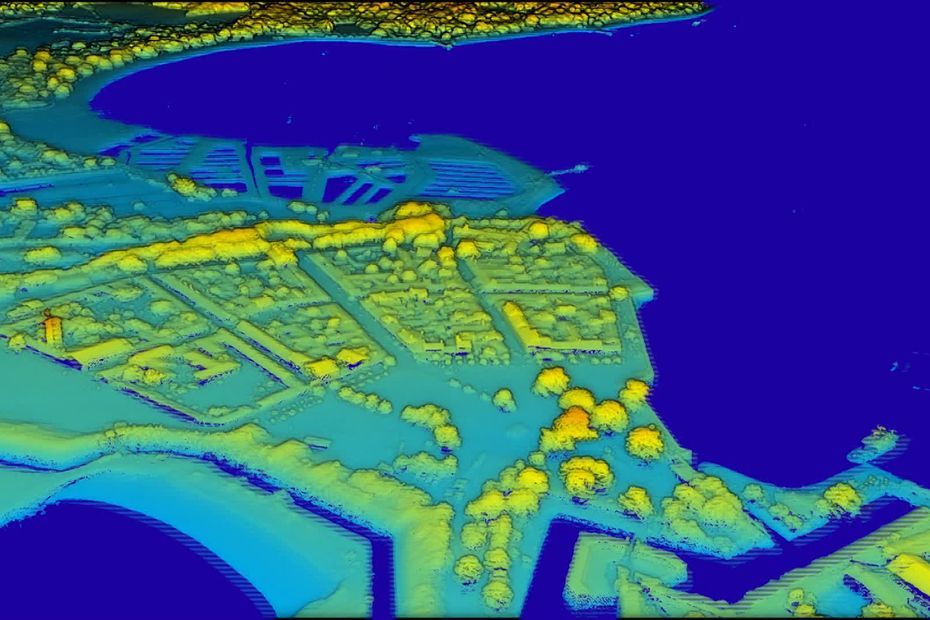
This is a first in France: the entire Charente-Maritime has been mapped in 3D and is accessible to the 463 municipalities of the department. A new visualization developed by the National Institute of Geographic and Forestry Information (IGN) with Lidar technology and in partnership with the Departmental Council. And the list of possible applications of this data is long, as Patrick Bouron, the South-West territorial director of the IGN, lists: “For coastal management and monitoring, for forestry management, for development, for agriculture… There are a huge number of areas concerned by this data. »
The island of Aix in 3D thanks to this new IGN-Lidar technology
•
© IGN – Lidar
And the scope of this new technology also concerns ecological transition, prevention of risks of submersion or flooding or land use planning:
If we make good use of this data, we can carry out many projects to install wind turbines or something else. This data is not only used for wind power, it can be used in the case of watersheds, for river unions.
Magali NoiraultGeographic information service manager – Department 17
The opportunities for this new technology are vast; it has already made it possible to find the natural bed of the Trézence River.
Report by Pierre Lahaye and Marc Millet :
duration of video: 00h01mn48s
IGN has developed technology that allows Charente-Maritime to be mapped in 3D.
•
©France Televisions


