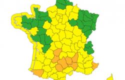


An autumn episode in the Cévennes causes flooding in the South-East of France. This Wednesday, three departments are still placed on Orange vigilance. Ardèche is on flood and rain-flood alert, Gard is on flood, rain-flood and storm alert, Lozère is on rain-flood and storm alert. Orange vigilance is lifted in Var and the Alpes-Maritimes, but the Alpes-Maritimes will again be placed on orange vigilance on Thursday, warns Météo-France.
Eric Turpin
In addition to the Cévennes episode, a “low pressure system returns to the country”. In total, Météo France therefore plans to place nine departments on orange vigilance on Thursday : Ardèche will always be on orange alert for floods and rain-floods, Gard for floods, rain-floods and thunderstorms, Lozère and the Alpes-Maritimes for rain-floods and storms, and Aveyron, Corrèze, Lot , the Pyrénées-Atlantiques and the Tarn for rain-flooding.
Eric Turpin
Concerning the Cévennes episode in the South-East, “sometimes intense rain is underway in the Cévennes and will continue until the end of Thursday”details Météo France. “Over the whole episode”the accumulations could reach “200 to 300 mm on the Cévennes relief” within 48 hours, with “400/450 mm possibles” locally, “or even very occasionally more”.
On the Alpes-MaritimesMétéo France evokes a new rainy and stormy episode from midday on Thursday, with 70 to 80 mm in a short time, even “100 mm locally on the relief”. Of the “intensities comparable to what we have experienced in recent episodes”. The lull is expected for the night from Thursday to Friday.
On the Pyrénées-Atlantiques, of the “Incessant stormy showers will set in” Thursdayi “and end up giving very significant accumulations of rain, of the order of 100 mm in places, in particular on the Basque mountains”.
On Corrèze, Lot, Tarn and Aveyron : “rains and storms will set in” in the afternoon Thursdayt “last until early Friday morning”. They will persist into the evening and night. Météo France forecasts “30 to 50 mm in two to three hours” under the storms and more, over the entire episode, “cumulative amounts of 50 to 90 mm of rain” with “possible peaks around 100 mm towards the Lot and the west of Aveyron”.
Roads cut and businesses evacuated
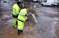
Faced with the current Cévennes episode in the South-East, local communities and authorities are taking certain measures and calling for caution. HAS NiceOr “significant amounts of rain are expected”the town hall announced in a press release that it had activated a vigilance unit and made the decision to close parks and gardens but also access to beaches and the coastal path. Still in the Alpes-Maritimes, Antibesparks, gardens, cemeteries and coastal paths are also prohibited from entering. The city of Cannes also calls for the greatest caution and invites residents to put in place appropriate precautionary measures (cofferdams and other personal protective equipment), reports France Bleu Azur.
Several roads are cut Mandelieu-la-Napoule and Grasseto the west of the department because they are flooded or threaten to be. No injuries were reported but one person, surprised by the rising waters Pégomaswas rescued. She was in her vehicle and was therefore able to escape unharmed. Several businesses in this municipality were evacuated. This concerns around thirty people, firefighters tell France Bleu Azur. They intervened for flooded cellars in Vence, Mouans-Sartoux and Grasse.
In the Gardas a precaution, the departmental council made close ten submersible bridges on the roads. The Anduze town hall has blocked access to the lower parts of the town, reports France Bleu Gard Lozère. The prefecture has decided to suspend school transport for the day of Thursday on “a large northern half of the department”.
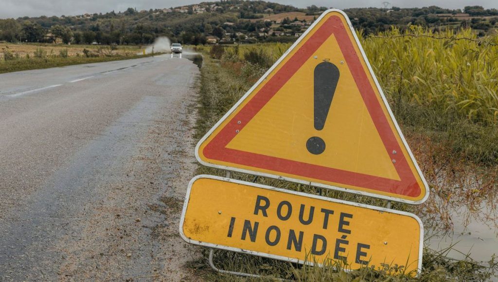
In the Ourprecipitation, “locally intense“according to the prefecture, risk giving “punctual accumulations of 80 to 120 mm in just a few hours under the least mobile storms, facilitating runoff”before fading at the end of the day. The authorities recommend limiting travel and warn about “significant runoff (which) may occur due to dry soil”: “do not drive across fords, submersible bridges or underpasses, or on a flooded road”they clarified, recalling that “30 cm of water is enough to take away a car”.
Regarding the LozereMétéo-France recorded 97 millimeters of rain in Rousses during the night from Tuesday to Wednesday. In the Cévennes, between Lozère and Gard, widespread accumulations of “200 to 300 millimeters” are expected on the relief, with “points at 350 millimeters or more” over 48 hours by the end of the day Thursday, warns the meteorological agency.
A total interruption of traffic between Alès in Gard and Langogne in Lozère was decided on Wednesday morning by the SNCF, until Friday morning, “for the safety of travelers and in order to avoid any incident“. “This line closure is a precautionary measure during bad weather.”explained the SNCF on-call service to AFP.