A complete loss of bearings. Hussein Khalil, an Uber driver in Beirut, recently saw his GPS tell him that he was in… Rafah, in the Gaza Strip! The reason? It is apparently linked to the current jamming in the region, which the Lebanese authorities blame on Israel.
The jamming is one of many forms of the war that has been going on for nearly nine months in the south of the country between the powerful Lebanese Hezbollah and Israel. Since Hezbollah opened the front against Israel on October 8 in support of its Palestinian ally Hamas in Gaza, Beirutis have regularly noticed disruptions in the indication of their geolocation, particularly on Google maps.
Hussein Khalil shows screenshots showing him in Rafah, at Beirut airport or outside the capital. “A client called me to ask if I was in Baalbeck,” more than 60 km east of Beirut, “and I told her I would be there in two minutes,” he says.
The disruption of geolocation via transport applications such as Uber is due to interference in the signals of the GPS system, which the Lebanese government accuses Israel of being behind.
“Disrupt Hezbollah’s communications”
Freddy Khoueiry, a Middle East security analyst at RANE Network, explains how “Israel uses GPS jamming primarily to disrupt or interfere with Hezbollah’s communications.” He says Israel also uses “GPS spoofing technology, which is another tactic used to send false GPS signals, in order to … disrupt the use of drones and precision-guided missiles,” which Hezbollah uses to attack Israel.
Since June 28, the level of interference has appeared high on the GPS Jam site, which specializes in collecting data on the interruption of geographic location signals, above Lebanon and certain regions of Syria, Jordan and Israel.
An Israeli Defense Ministry spokesman said he was “not currently in a position to discuss operational matters.” However, the Israeli military made clear at the start of the war that Israel had disrupted GPS navigation “proactively for various operational needs,” informing the public that the move could disrupt applications that use geolocation.
Airplane pilots adapt
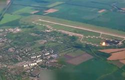
Concerned about the impact of interference on air navigation, the Lebanese government filed a complaint with the UN Security Council on March 22. It denounces “Israel’s attacks on Lebanese sovereignty by disrupting navigation systems and the safety of civil aviation” in Lebanese airspace.
Since March, the General Directorate of Civil Aviation has been asking pilots flying to and from Beirut to “rely on ground navigation kits and not rely on the GPS signal they receive due to interference,” says its president, Fadi el-Hassan. “It is inconceivable that a pilot who wants to land at our airport cannot benefit from the GPS function due to interference from the Israeli enemy,” he laments.
Avedis Seropian, a pilot for five years, says he has completely given up on GPS in recent months. “We are used to it. We fly based on the compass and the paper map,” he says. But he says the challenges are unprecedented: “Sometimes we are 32 km above sea level and the screen shows us above the summit of Qornet el-Sawda,” Lebanon’s highest point at over 3,000 meters. “When you can’t see the ground, what do you do? You can quickly find yourself in a state of panic and that can lead to an accident or a disaster.”


