Update July 1, 2024 at 11:00 p.m.
It is the earliest Category 4 hurricane in Atlantic history and made landfall early Monday morning. Its consequences could be catastrophic. Details.
Peaks at 240 km/h
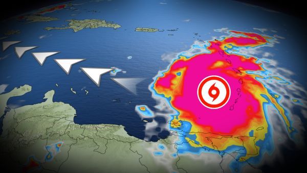
By Saturday morning, it was a tropical storm. Just 24 hours later, it had strengthened to a Category 4 hurricane. A remarkable intensification that puts Beryl in the annals of history: it became the earliest Category 4 hurricane in history for the Atlantic basin.
On Monday at 11:10 a.m., Beryl made landfall in Carriacou, Grenadines. At the time of writing, its maximum sustained winds are 150 mph (240 km/h), still a Category 4 storm. A tropical storm warning remains in effect for St. Vincent and the Grenadines as Beryl continues to track northwest.
A tropical storm warning is also issued for the southern coast of the Dominican Republic and for Haiti.
He continues his journey towards Mexico
The hurricane continues its trajectory in the Caribbean Sea towards the northwest. A weak intensification remains possible for the next 24 hours. It will subsequently lose intensity from Wednesday.
A hurricane watch is in effect for Jamaica, with Beryl expected to pass the island nation as a hurricane on Wednesday and enter the Yucatan Peninsula as a tropical storm on Friday.
The next few hours are crucial: up to 150 mm of rain is expected along the coast of Hispaniola. In the Grenadines and Grenada, Beryl could dump up to 250 mm locally. A risk of flash floods is to be monitored.


