A cold snap lasting several days hits France with negative temperatures upon waking and significant frost.
After a disrupted week, the weather calms down in France this Monday, January 13, with the sun imposing itself almost everywhere throughout the day, once the morning gray has passed. However, it is accompanied by severe cold. Temperatures ranged from -7 to -2 this Monday morning in three-quarters of the country, according to The Weather Channel. On the Mediterranean rim, it is around 0 degrees Celsius. Over a large part of the country this afternoon, temperatures will not exceed 3 degrees, except around the Mediterranean where it can rise to 8 degrees.
These values are therefore between 3 and 5 degrees below seasonal norms. Night frosts have also become widespread across the country. It is a real “cold snap” which has set in in France, but which is quite classic in the middle of winter. The mistral and tramontane blow from the Rhône valley to Roussillon via Provence, accentuating the icy feeling.
This Monday, Météo-France has thus placed several departments on extreme cold yellow vigilance, which are facing negative minimums and temperatures which are struggling to rise. There are 34 of them: Aveyron, Lozère, Cantal, Haute-Loire, Loire, Saône-et-Loire, Nièvre, Jura, Yonne, Côte-d'Or, Doubs, Haute-Saône, Haute-Marne, Aube, Marne , Meuse, Meurthe-et-Moselle, Territory of Belfort, Haut-Rhin, Bas-Rhin, Moselle, Meuse, Ardennes, Loiret, Cher, Loir-et-Cher, Indre, Creuse, Corrèze, Haute-Vienne, Vienne, Deux-Sèvres, Vendée and Loire-Atlantique. This being said, according to Météo-France, “the temperatures remain cold but do not constitute a dangerous meteorological phenomenon”.
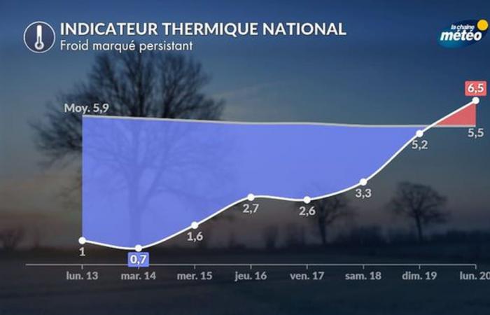
This vigilance is maintained for Tuesday. The day is, in fact, the coldest of the week. The good weather will persist after the freezing fogs of the morning. From Wednesday, gray weather will return north of the Seine, in Hauts-de-France and in Ile-de-France in particular. Temperatures will still be negative in the morning over part of the territory, but will rise between 3 and 14 degrees in the afternoon. It will still be very cold in the east, while in the southeast, temperatures will be milder in the afternoon. Despite everything, this date marks a big change.
Several degrees will gradually gain during the day in the second part of the week to reach seasonal norms at the end of the weekend. Next week, temperatures should even exceed seasonal norms. This cold snap should therefore not last more than a few days: next Sunday, it's over!


