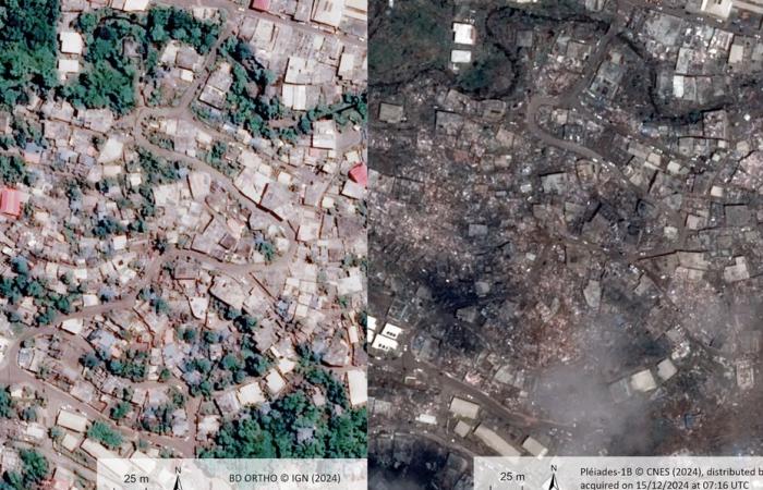
Saturday December 14, 2024, Cyclone Chido devastated the territory of Mayotte, leaving behind significant damage and a heavy loss of life. In this context, the Ministry of the Interior relies on satellite images to help populations and guide rescue teams.
The essentials of the day: our exclusive selection
Every day, our editorial team reserves the best regional news for you. A selection just for you, to stay in touch with your regions.
France Télévisions uses your email address to send you the newsletter “The essentials of the day: our exclusive selection”. You can unsubscribe at any time via the link at the bottom of this newsletter. Our privacy policy
These are impressive photos. A before and after, which illustrates the force of Cyclone Chido which ravaged the Mayotte archipelago on Saturday December 14, 2024. Today, space technology makes it possible to come to the aid of populations and to direct the rescue teams involved. on the affected areas.
In the event of major disasters, roads and bridges are often damaged and communication systems cut off. It is often very difficult for emergency services to have an overview of disaster areas and priority locations.
In Mayotte, optical and radar satellites are programmed to map the disaster area. CNES provides images using the French “Pléiades” satellites at the heart of this system. These images are precise enough to make it possible to characterize the impact of the cyclone on the building, through the provision of damage gradation maps.
It was the Ministry of the Interior – through the Operational Center for Interministerial Crisis Management (COGIC) – which called on the services of CNES. How ? By triggering the “Copernicus Emergency Management Service”. CEMS is a service set up by the European Commission based on the model of the International Charter “Space and Major Disasters” and can be activated by European countries and European delegations in countries around the world.
This device makes it possible to put space technologies at the service of rescue teams following natural or technological disasters.
Extensive satellite data is made available, thanks to a fleet of more than 270 satellites.
“We will have an overview to assess the damage and above all to see which areas are most affected, to send help there” explains Emilie Bronner, project manager of the international space and major disasters charter at CNES. “Is this road passable for rescue or not? The difficulty is that there is debris everywhere. So, it’s really difficult to have a view even from space. But it We need to know, for example, whether an airport is passable or not. This is essential for sending aid.” explains the specialist.
- -


