An atmospheric river is poised to slam into the Eastern United States on Wednesday, bringing torrential rain, powerful winds and significant disruptions.
The storm, which is forecast to intensify into a ‘bomb cyclone,’ will impact areas from the Southeast to New England, causing widespread travel delays, flooding and power outages.
The storm began producing severe thunderstorms and heavy rain in the southeast early on Tuesday and is expected to rapidly intensify as it moves up the East Coast.
Through Wednesday, it is expected to undergo bombogenesis—a rapid drop in atmospheric pressure of at least 24 millibars in 24 hours. This process will create a vacuum-like effect, drawing in intense winds and rain for an atmospheric river.
“The main impacts from the atmospheric river event in the East today will be in the form of heavy rain, strong to damaging wind gusts, and even a defined line of thunderstorms that can turn severe,” Bradon Buckingham, a meteorologist at AccuWeather, told Newsweek.
“This can lead to low-lying flooding, rises on rivers and streams, and result in numerous travel delays. Factoring in the wind and thunderstorm risk, there is also a risk for power outages from this storm.”
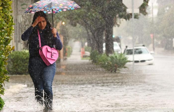
A person walks along a flooded street during a powerful, long-duration atmospheric river storm, on February 4, 2024 that hit Santa Barbara, California. Atmospheric rivers hit both coasts of the U.S., bringing torential rain up from the tropics.
More
Mario Tama/Getty
The storm’s central pressure will plunge dramatically, unleashing gusts between 50 and 70 mph from eastern North Carolina to southeastern Maine.
Isolated gusts could reach 85 mph, akin to a strong tropical storm or hurricane, according to AccuWeather forecasts.
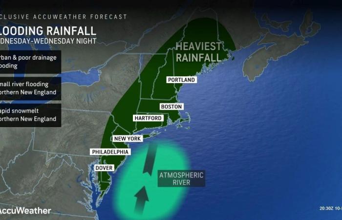
The storm will deliver 1 to 4 inches of rain across much of the East, with localized totals of up to 8 inches in the Northeast.
Rainfall will trigger urban flooding and elevate river and stream levels. Areas with substantial snowpack, particularly in Vermont, New Hampshire and Maine, face an amplified flood risk due to rapid snowmelt.
“Atmospheric rivers, swift-flowing currents of moist air, are known for their ability to produce heavy rain across the West Coast, often resulting in significant flooding,” AccuWeather chief meteorologist Jonathan Porter said in a media advisory on Tuesday.
“They can also occur along the East Coast of the United States, as will be the case with the storm on Wednesday into Wednesday night.”
According to Porter, this atmospheric river will be “unusually potent” and moisture-laden. The tropical moisture being dumped on the East Coast has travelled some 2,000 miles from the Caribbean Sea.
Flat or shallow-angle roofs laden with snow could also collapse under the added weight of rainwater, forecasters warned.
Major transportation hubs along the Interstate 95 corridor, including Philadelphia, New York City and Boston, are expected to see delays due to heavy rain, poor visibility, and localized thunderstorms.
In the mid-Atlantic and Northeast, severe thunderstorms could spawn isolated tornadoes. The National Weather Service has issued a “Slight Risk” warning for damaging wind gusts across eastern North Carolina and southern New England.
Powerful winds will accompany the storm, even outside of thunderstorms. Coastal areas of the Northeast are bracing for widespread power outages and potential damage to property and infrastructure.
Residents are urged to secure outdoor Christmas decorations, trash bins and other items that could become dangerous projectiles.
Further inland, wind gusts between 30 and 50 mph will sweep through the central Appalachians and extend to the Atlantic Seaboard by Thursday.
More than 12,000 people in Connecticut, New York State, New Jersey and Pennsylvania are already without power, according to poweroutage.us, though it is not immediately clear if these are storm-related.
Flooding and rainfall map for Wednesday on the East Coast. An atmospheric river will draw moisture up from the Caribbean Sea, likely sparing flooding across swathes of the East.
AccuWeather
Unlike atmospsheric rivers on the West Coast, which Buckingham explained tend to hit more frequently than their East Coast cousins, this river in the sky is oriented parallel to the land.
Conversely, the similar storms that hit the Pacific Northwest last month struck perpendicular to the coast.
“Often times, because of the orientation of the moisture and the mountainous terrain along the West Coast, events can be more extreme compared to what occurs on the East Coast,” he added.
Relationship Between the Atmospheric River and the Bomb Cyclone
When atmospheric rivers and bomb cyclones combine forces, they create an exceptionally potent weather system capable of supercharging storms.
The atmospheric river, a high-altitude stream of concentrated moisture, serves as the fuel, while the bomb cyclone, characterized by rapidly plunging atmospheric pressure, acts as the engine driving the system.
As the bomb cyclone’s pressure drops sharply, it generates a vacuum effect that draws in vast amounts of moisture from the atmospheric river.
This interaction sets off a feedback loop: the cyclone strengthens as it absorbs more moisture, and in turn, its increased intensity allows it to pull in additional moisture, often from thousands of miles away.
Do you have a tip on a science story that Newsweek should be covering? Do you have a question about atmospheric rivers? Let us know via [email protected].


