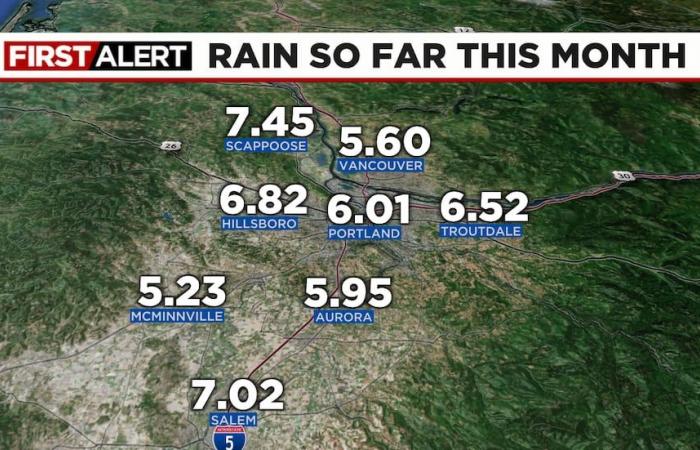
Today was a big soaker for part of the region as a band of rain sat right over far NW Oregon and SW Washington. The far north and west metro areas were soaked, but just a few light showers fell to the south and east. Over half an inch in Portland, but over one inch in Columbia and northern Clark counties!
As I was driving into work, I thought “this IS vintage Pacific Northwest November weather…so gray, dark, and wet”. Another round of solid rain is pushing through the metro area right now, then we should see more scattered showers and much drier weather the rest of this week.
QUICK SUMMARY
- There are no organized weather systems arriving the rest of this week and through the holiday weekend. No storms, strong wind, soaking rain, or significant mountain snowfall
- After a few showers Monday, Tuesday should be mainly dry. Most likely we’ll be all (or mainly) dry Wednesday through at least Saturday. Possibly Sunday too
- BUT, at best I see partial sunshine because we don’t have a dry easterly wind to blow away any overnight fog/clouds that develop. We are now in prime “inversion season” folks. If low clouds form in the valleys, it will be tough to get them to dissipate each day
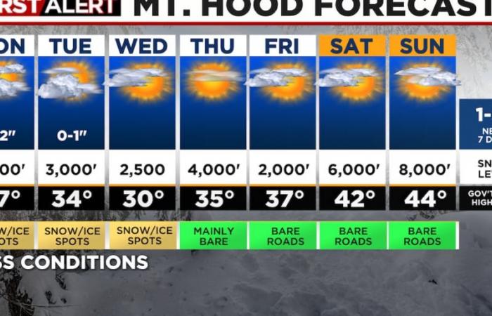
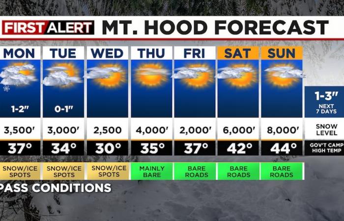
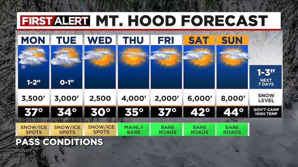
- Cascade travel is looking pretty good all the way through next Sundayjust some spots of snow/ice the next 2-3 mornings
- I would assume with some clearing later this week or early next, most of us should finally get a killing freeze
- There is no sign of stormy weather returning in the next 10 days, possibly longer.
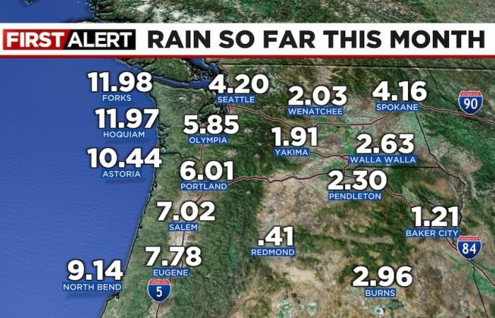
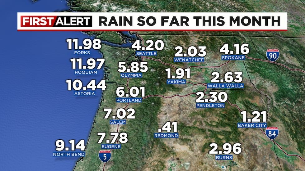
More rain talk…November is ending up slightly wetter and slightly warmer than average. At PDX, the monthly rain total just went over 6″ today, making it the wettest month since January.
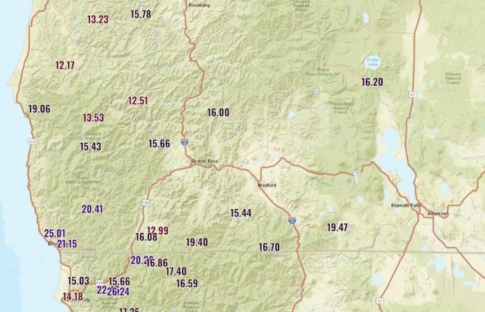
How about the rest of the region? Of course very wet along the coastline, but Burns has picked up almost a third of their yearly precipitation just this month. That’s very good in such a dry area; Pendleton did well too.
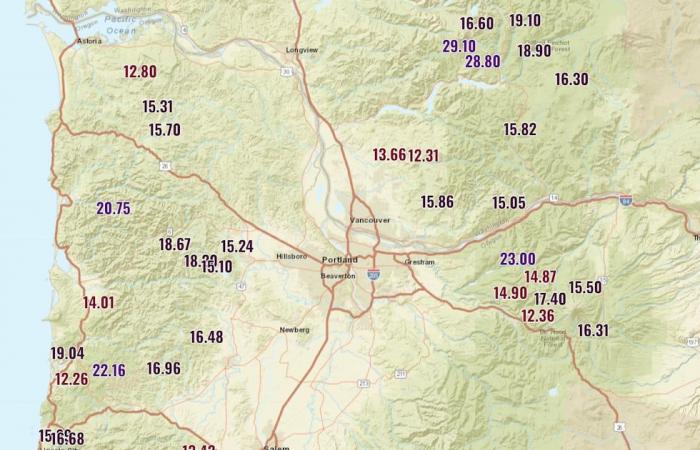
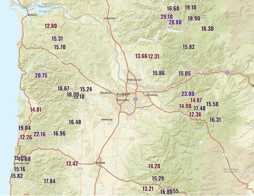
You are likely aware that the I-5 corridor in NW Oregon and SW Washington is flanked by a rain forest on each side (Coast and Cascade Ranges). There’s a reason for that. Check out the spots that picked up more than one foot of rain this month so far. That’s 12″ or more
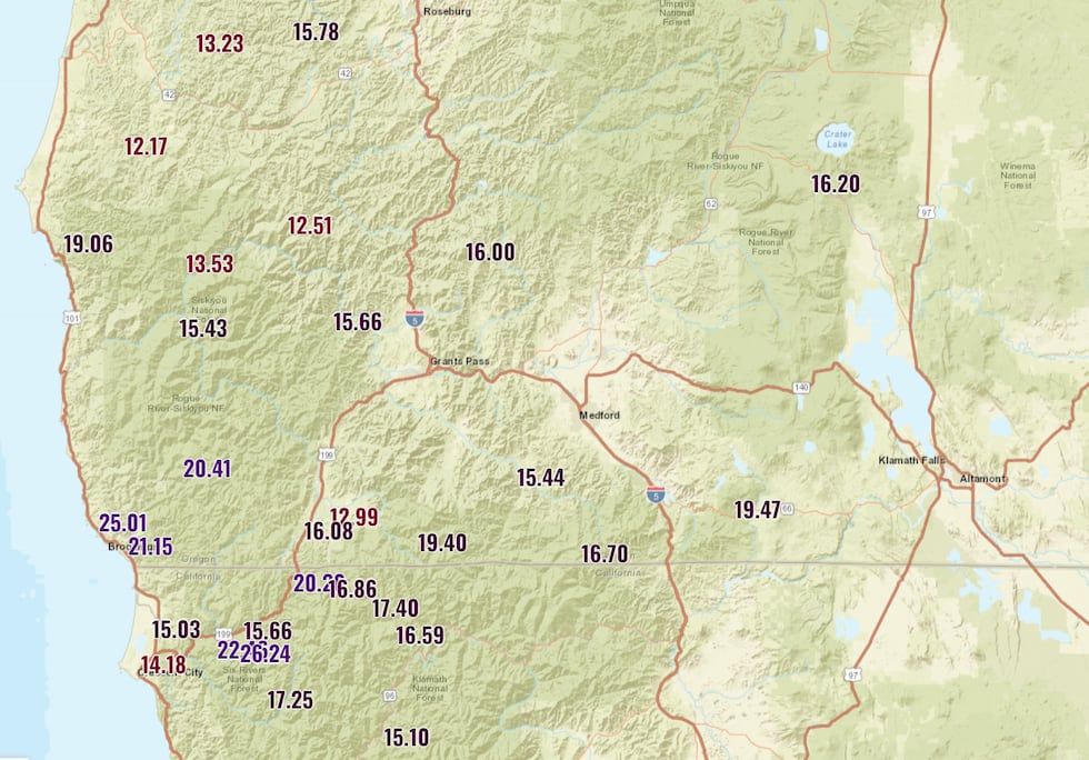
Now you don’t have to wonder why moss grows on those trees so well. One more stop…that atmospheric river that nailed SW Oregon last week really brought those totals up. The Siskiyous and southern Cascades were soaked, or (at higher elevations) have lots of snow on the ground. Again, a really good start to the wet season after so many months of dry weather.
WHAT’S AHEAD?
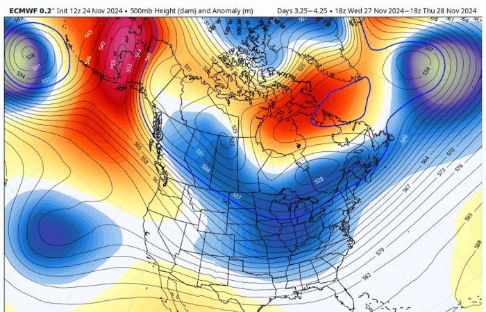
The big message is that some form of upper-level ridging wants to hang over the West Coast much of the next 10 days. It won’t be strong enough to block all weather systems during that time, but the few that make it will be weak. This loop shows 500 millibar heights and anomaly (warm colors are higher than normal heights). It covers Thanksgiving Day all the way through Monday, December 9th. This is quite the pattern shift from what we’ve seen in recent weeks. The warm ridging is replaced by cold winter temps in the eastern USA, and the troughing over the West Coast is replaced by an upper-level ridge.
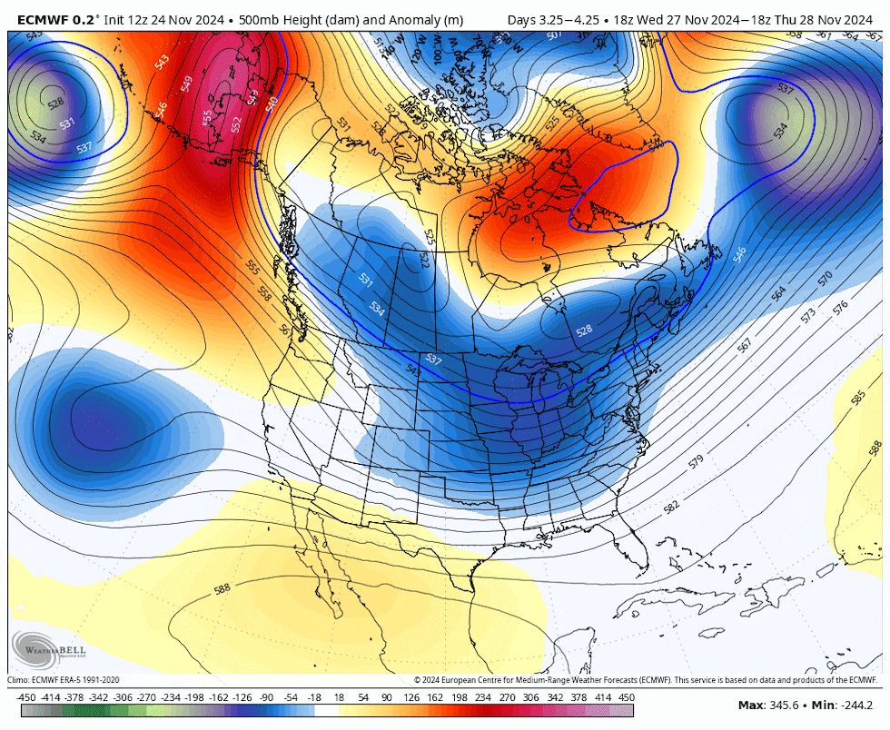
So it’s a pretty straightforward setup which tells me weather will be uneventful for much of the next 10 days. But two additional items I’ll be watching closely.
1) We can get strong east wind out of the Gorge with these big ridges. But typically the upper-level high needs to be over or east of us. That’s not the case through most of the Thanksgiving weekend. We’ll see if the position moves a little farther east NEXT week and we get our first cold/strong east wind of the season.
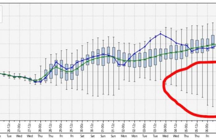
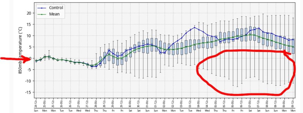
2) When the ridge is sharp like this, there’s always the possibility it suddenly “retrogrades” or shifts westward with just a few days’ worth of warning. When that happens the upper-level trough over central Canada can send a cold lobe southward and we are into the arctic-air business (possibly involving lowland snow). December can be primetime in our area for cold waves. Just something I’ll be watching. On a couple of different model runs I’ve seen a tendency for a trough to dig right down the east side of that upper-level high. In fact look at the 850mb temp ECMWF model ensemble forecast. The red arrow just shows the 0° line, which is pretty much a 4,000′ snow level. Notice the ensemble average (green) from Thanksgiving onward is well above zero. That says a warm airmass overhead. BUT, you see a lot of plunging “whiskers” after the 3rd. Clearly some of the ensemble members (circled in red) are trying to push the ridge westward; allowing a cold trough to dig southward. Just something to watch.
CASCADE TRAVEL
It looks pretty good this week. With very little new snow, there will just be a few pockets of snow/ice the next few mornings. Then as ridging takes hold Wednesday PM through the weekend, the atmosphere warms and you’ll likely only find patches over overnight/morning ice. Sorry skies, no fresh snow for the weekend, but it’s been an amazing start! Don’t get greedy this early.
Copyright 2024 KPTV-KPDX. All rights reserved.

