The current Cévennes episode should continue on Wednesday evening and Thursday October 17. The very heavy rains caused the rivers to swell. Around fifteen submersible bridges were closed, school transport was suspended. Here’s what we know at this point and what to expect in the coming hours.
The essentials of the day: our exclusive selection
Every day, our editorial team reserves the best regional news for you. A selection just for you, to stay in touch with your regions.
France Télévisions uses your email address to send you the newsletter “The essentials of the day: our exclusive selection”. You can unsubscribe at any time via the link at the bottom of this newsletter. Our privacy policy
The Cévennes episode which is currently hitting the Languedoc-Roussillon region is particularly intense. On the Cévennes relief, impressive accumulations over 48 hours are feared which could go up to 400/450 mm or even more. Nine departments have been placed on orange vigilance by Météo France: Gard, Lozère and Ardèche which were already on orange rain flood vigilance will be joined on Thursday by the Alpes-Maritimes, Aveyron, Corrèze, Lot and the Pyrenees -Atlantic and the Tarn.
Ardèche and Gard also remain on orange alert for floods and significant storm activity is also expected in Alpes-Maritimes, Gard and Lozère.
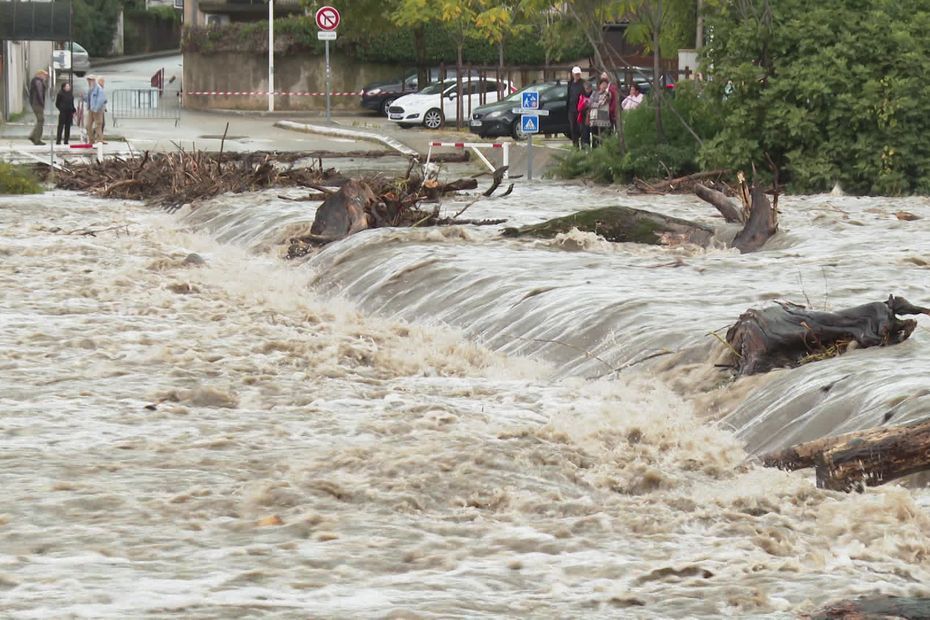
For several hours, torrential rains have been falling on the Cévennes reliefs, causing rapid saturation of the soil and swelling of the watercourses. According to Languedoc weather, the rains mainly concern the reliefs, notably between Aigoual and the Monts Ardéchois.
If certain rivers show signs of stabilization, others continue to rise, notably the Gardon d’Alès, which now exceeds 5 meters in Anduze, leading to overflows in the surrounding low-lying areas. The watersheds are saturated, and the authorities fear more significant flooding if the precipitation persists.
The episode is expected to intensify tonight, with increased precipitation expected. “A low pressure system is rising over the country and stormy precipitation will intensify in many regions“, Météo France alert.
The situation is expected to deteriorate further during the day on Thursday, when the most intense rains will occur. Météo Languedoc predicts that the peak of this Cévennes episode will occur in the afternoon of Thursday, with stormy rains affecting all of the departments of Hérault, Gard, Lozère and Ardèche. Rainfall could then reach intensities of 20 to 30 mm per hour, causing an increased risk of flash flooding.
Stormy rains are expected to persist in the Cévennes during the morning of Thursday, Météo Languedoc further specifies, before spreading to the plains of Aude and the Pyrénées-Orientales, although without serious consequences in these regions. On the other hand, in mountainous areas, precipitation is expected to further intensify, bringing the total accumulations over 48 hours to very high levels, with peaks of up to 500 mm on the southern slope of Mont-Lozère.
Due to rising water levels and flooding in several rivers, 15 submersible bridges were closed in Gard. These closures mainly concern areas near Gardons and Cèze, where overflows have been reported. In its situation update published at 4 p.m. this Wednesday, the prefecture recommends “do not attempt to cross these closed infrastructures, and regularly consult the site www.inforoute30.fr to check the condition of the roads and new closures“.
Here is the list of closed submersible bridges.
RD906 Chamborigaud temporary bridge
RD284a: Pont des Massiès in Thoiras
RD284: Eastern access bridge to Corbèso
RD129a: Anduzeo submersible footbridge
RD50B: Paussan Bridge in Mialet
RD20C: Bridge over the Rieutord hamlet of Villaret
RD243A: Pont des Clapouzes in Chambon Route du Martinet Neuf
RD386: Grand turning bridge in Peyremal Fording the Vis in Vissec
RD814: Bridge over the Vis between Alzon and Vissec
Road closed RD 278: low point at the Pont de Rastel in Génolhac
RD386/386A: Pont des Drouilhedres in Besseges
RD187A: Bridge over the Cèze at Rivières
RD187C: Bridge over the Cèze at Rochegude
RD106: Cassagnoles Bridge in Vezenobres
D22: Pont de Dions sur le Gard
The map of closed bridges
The prefect of Gard also took the decision to suspend school transport in a large part of the department for the day of Thursday October 17. This prevention measure concerns the northern half of the department, where the risk of flooding is highest. All school transport routes crossing this area are canceled, even if the final destination is in an area not affected by flooding. However, “schools will remain open and will welcome boarding students or those who still manage to get there“, specifies the Gard prefecture.
Safety instructions
The Gard prefecture recommends that motorists limit their travel.as much as possible“, notably in risk areas where flooding is already underway.”. It is also advisable to never attempt to cross a submerged road, even if the water appears shallow.
“Do not cross a submersible bridge or ford if it is closed or beginning to become submerged“, also detail the State services.
The prefecture advises residents to keep informed of developments in the situation by regularly consulting three websites: