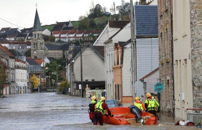
Although it is impossible to predict winter precipitation in Pas-de-Calais, the soils are very humid and the water tables are full. According to experts, conditions are not favorable if further heavy rains fall in the coming weeks.
The essentials of the day: our exclusive selection
Every day, our editorial team reserves the best regional news for you. A selection just for you, to stay in touch with your regions.
France Télévisions uses your email address to send you the newsletter “The essentials of the day: our exclusive selection”. You can unsubscribe at any time via the link at the bottom of this newsletter. Our privacy policy
It's no secret: for several months, rain has not stopped falling in Hauts-de-France as in almost the entire country. A wet autumn which, in Pas-de-Calais, brings back very bad memories as winter approaches. In November 2023, the department undergoes several episodes of precipitation whose accumulation is unprecedented. Consequence: these rains cause flooding in the Aa, Liane and Canche basins, sometimes lasting more than a century.
Although it has been a year, residents of Pas-de-Calais fear reliving the nightmare of flooding again in the coming weeks. We interviewed several experts to take stock of the current hydrological situation in the department.
What are the objective and scientific elements allowing us to assess the risk of new floods this winter? Is the current hydraulic situation similar to that of October 2023 in Pas-de-Calais, a few days before the historic floods ? Elements of response.
Winter precipitation impossible to predict
The historic floods of November 2023 and January 2024 resulted in triggering factor the amount of precipitation. In an interministerial report published in July 2024, the inspectors recall that the torrential rains which fell on the department – more than 700 millimeters of cumulative rain over the last two months of the year 2023 – caused “floods far exceeding centennial levels”.
Duration of return of cumulative rain from November 1 to 15, 2023 in Pas-de-Calais.
•
© Météo France
In Pas-de-Calais, heavy rainfall was therefore the primary reason for the flooding. Gold, predicting a flood is impossible without having reliable forecasts, both in their temporality, their spatialization and their quantity. Data that no meteorological service can provide for next winter.
However, the precipitation totals for the past year are “largely surplus” in Pas-de-Calais, indicates Météo France, particularly in September. In 30 days in the department, it rained on average 2.5 times more compared to the month of September 2023, making September 2024 the 10th wettest month since 1959. September 2024 is also the month during which Calais recorded 19 days of rain, compared to 8 to 12 on average. Total rainfall reached more than 200 millimeters on the heights of Boulonnais, 150 millimeters on the coast.
Accumulations of rain which could make us fear the worst for the weeks to come? Impossible to say. “We cannot predict that we will have episodes of 15 days with extraordinary precipitation like last year”summarizes Bruno Jacquemin, deputy director of Météo France in the North zone.
Soil humidity, water table levels… data that does not reassure
There is therefore no reliable trend regarding seasonal precipitation forecasts for this winter in Pas-de-Calais. In its bulletin of major trends for the next three months, Meteo France indicates that“no precipitation scenario is favored for France”. However, other elements influence the potential risk of flooding, including soil humidity, the level of water tables or hydraulicity (i.e. the flow of watercourses).
Data that we have studied at the department level, and which is not reassuring. Soil humidity, groundwater levels and watercourses in Pas-de-Calais are higher than the seasonal averages, and much higher than the values recorded on October 1, 2023, i.e. one month before the historic floods. The conditions are therefore considered unfavorable in several respects by Météo France. “We leave with a handicap, admet Bruno Jacquemin. If the same phenomenon occurred this winter in Pas-de-Calais, the consequences would be even more severe.” Before qualifying, recalling that “it is impossible to predict knowing that the phenomenon (from November 2023, editor's note) has a frequency of appearance of the order of a hundred years”.
- Wetter soils than in September 2023
In France, the soils are much wetter this October 1 than the average observed over more than fifty years on the same date. A similar observation in Pas-de-Calais. Météo France calculates the humidity of the soil in the first two meters, which act as a sort of sponge when the water falls and infiltrates.
Aggregated soil humidity index, from October 20, 2023 to October 20, 2024, in the Pas-de-Calais department.
•
© Météo France
While they were 60% humid a year ago, the rate reached 80% as of October 20, 2024. “The sponge is already pre-filled, so it will act less as a buffer”popularizes Bruno Jacquemin. Understand that currently, when it rains, the speed at which the water sinks into the ground is limited because the retention capacity of the sponge only works at 20%. “Water that cannot be stored in retention and that cannot be evacuated to aquifers evacuates laterally towards rivers or stagnates and can flood”, explains Bruno Jacquemain. A situation which can be different in the same basin, as is the case around the Aa: upstream, the excess water can rush down the slopes of the Boulonnais while in the plain, there is no longer any slope and the water stagnates.
- Very high groundwater level
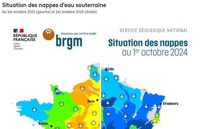
The level of the water tables is very high compared to the annual averages observed over the last fifteen years, and higher than at the same period in 2023. Characterized by the IPZ – the Standardized Piezometric indicator – the level of the water tables is spread over a scale of 7 classes, from extremely low to extremely high. Thus, on October 1, 2024, the water tables of Pas-de-Calais are at level 6 on a scale of 7.
The cause is the exceptional rainfall in part of the department during winter, a period when the water tables recharge most quickly. Despite natural draining during the summer months due to evaporation, levels remain above normal. Near Wirwignes for example, the BRGM indicates that in September, “its level is increasing showing that winter recharge has already started”. One level “moderately high”i.e. a level which returns approximately every 3 to 5 years on average in September, specifies the BRGM.
In its latest monthly bulletin reporting on the situation on a national scale published in mid-October 2024, the BRGM – Geological and Mining Research Bureau – carried out an inventory of the state of the water tables and the risk of flooding. A risk that exists, given the high levels recorded and the water table in Boulonnais. It is one of the so-called reactive aquifers, considered to be the most at risk from flooding. “Aquifers could no longer fulfill their role as a buffer and therefore no longer limit the impact of heavy precipitation and flooding of rivers”indicates the BRGM. These very full water tables could thus be an aggravating factor in several scenarios: runoff, overflows or the phenomenon of rising water tables feeding the watercourses.
- River flows higher than a year ago
Finally, hydraulicity is the third factor to take into account. It corresponds to the ratio of the monthly flow of a watercourse compared to its average over several years. Data which allows us to know the flow of water, watercourse by watercourse.
In September 2024 in Pas-de-Calais, river flows are higher than those measured last year at the same period, and even significantly higher than the observed annual average. Thus, in the Aa and Canche basins, the river flow recorded in September 2024 is higher than the average river flow recorded over the last 5 years.
Faced with an unknown situation, one element must however be taken into account: unlike last year, numerous works have been undertaken in the basins affected by the floods. Thus, since the spring, state services have carried out more than 630 so-called emergency work operations. Maintenance of waterways, removal of ice jams, consolidation of dikes and banks or targeted cleaning of certain rivers… projects to repair the considerable damage caused and allow better water flow. Cost of operations: nearly 98 million euros.
Since the summer, a second phase of so-called structuring works has been underway across the four corners of the department to reduce as much as possible the consequences of future floods. 174 operations are scheduledwith the aim of being all completed before the end of 2024, for an amount of 42 million euros.
The progress of so-called structuring works in the Pas-de-Calais department as of October 18, 2024.
•
© Cécile Detez / France Télévisions
Among these projects, the creation of retention basins or the installation of pumps at strategic points. Necessary work, indicates the prefect of Pas-de-Calais. Will they be sufficient if floods similar to winter 2023 occur again? “Certainly not”he admits, however.
It takes very little for this precarious balance to shift.
Arnaud Gauthier, hydrogeologist and professor at the University of Lille
“No one knows the scenario, summarizes Arnaud Gauthier, hydrogeologist and professor at the University of Lille. But the receiving elements do fear that in the event of rain, not necessarily very intense, we could relive new events this winter”. It is based in particular on a study that he has been carrying out for several months in Recques-sur-Hem. “I was still in the field a month ago, and we see the watercourses beginning in places to react very quickly in the event of light rain and to overflow slightly”. Before concluding. “It only takes very little for this precarious balance to tip over.”


