

Hurricane Helene is expected to bring historic flooding and a high wind threat to South Carolina, North Carolina and Georgia now through Friday afternoon. ***WHEN WYFF NEWS 4 IS LIVE ON THE AIR YOU CAN WATCH ABOVE***Our area has now begun to see direct impacts from Hurricane Helene’s outer bands as the storm continues making its way north. Just after 9 pm Thursday, a Tornado Watch has been issued for Laurens, Union, and Greenwood Counties in South Carolina until 8 am Friday. TORNADO WARNING:A tornado warning is issued when a tornado is indicated by radar or sighted by weather spotters. If a tornado warning is issued for your area, you should immediately seek shelter. A tornado warning can also be issued without a tornado watch being already in effect. Tornado warnings are usually issued for a duration of about 30 minutes.TORNADO WATCH:A tornado watch is issued by the National Weather Service when conditions are favorable for the development of tornadoes in and close to the watch area. The NWS said a tornado watch is usually issued for a duration of four to eight hours. It’s usually issued well in advance of the actual occurrence or severe weather. The National Weather Service said this will be the “worst flooding we’ve had in the modern era” for some areas as heavy rainfall continues. Right now, Helene is a Category 4 hurricane and is expected to downgrade back to a Cat. 3 after the storm makes landfall in Florida.Helene is expected to be a Category 2 well inland and begin to further weaken after making it past southern Georgia.The storm is expected to bring wind gusts of more than 70 mph to the Upstate area of South Carolina, as well as heavy rain that will continue to shatter records.Heavy rain and gusty winds are expected to cause flooding, downed trees and power outages. Tornadoes can not be ruled out.Flooding is going to continue to be a concern in much of the Upstate and Western North Carolina overnight. Areas in the Upstate could get an additional 2 to 3 inches of rain in areas east of Greenville and an additional 3 to 5 inches in areas west of Greenville. This is on top of the several inches that have already fallen. After 10 pm Thursday, expect a 2-3 hour lull before conditions start to really pick back up. Parts of Western North Carolina are expected to get an additional 4 to 7 inches on top of what’s already fallen. Three-day-rain total records have been broken in many areas with officials calling it a “500 year historic flooding.”A Tropical Storm Warning is in place through Saturday for our area. A Tropical Storm Warning is issued when Tropical Storm conditions, including winds of 39-73 mph, are expected in a specified area within 36 hours or less. For the latest alerts in your area, click here. Here is the latest timeline on what to expect: Thursday night: Rain continues in our area with winds increasing. Winds will be between 30 to 40 mph with gusts around 45 mph. Helene is expected to landfall in Florida as category 4 on Thursday night. Thursday night into Friday morning: Heavy rain continues as Helene races north. Winds will be between 30-40 mph with gusts of 70 mph. Concerns are flooding, downed trees and downed power lines as the core of the storm makes its way through our area. Friday morning: The strongest winds will be early Friday morning between 30-40 mph with gusts of 50-60 mph. Rain continues. Concerns are flooding, down trees and downed power lines. The storm moves out by late Friday morning. Saturday: Partly sunny with temperatures in the upper 70s. Latest video forecastMap roomExtended forecastHow to get weather alerts
Hurricane Helene is expected to bring historic flooding and a high wind threat to South Carolina, North Carolina and Georgia now through Friday afternoon.
***WHEN WYFF NEWS 4 IS LIVE ON THE AIR YOU CAN WATCH ABOVE***
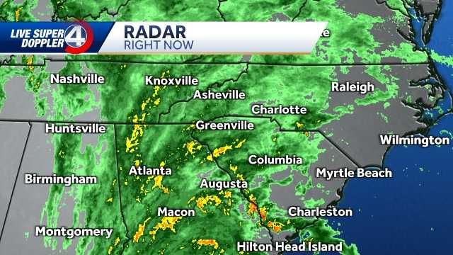
Our area has now begun to see direct impacts from Hurricane Helene’s outer bands as the storm continues making its way north.
Just after 9 pm Thursday, a Tornado Watch was issued for Laurens, Union, and Greenwood Counties in South Carolina until 8 am Friday.
TORNADO WARNING:
A tornado warning is issued when a tornado is indicated by radar or sighted by weather spotters. If a tornado warning is issued for your area, you should immediately seek shelter. A tornado warning can also be issued without a tornado watch being already in effect. Tornado warnings are usually issued for a duration of about 30 minutes.
TORNADO WATCH:
A tornado watch is issued by the National Weather Service when conditions are favorable for the development of tornadoes in and close to the watch area. The NWS said a tornado watch is usually issued for a duration of four to eight hours. It’s usually issued well in advance of the actual occurrence or severe weather.
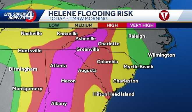
The National Weather Service said this will be the “worst flooding we’ve had in the modern era” for some areas as heavy rainfall continues.
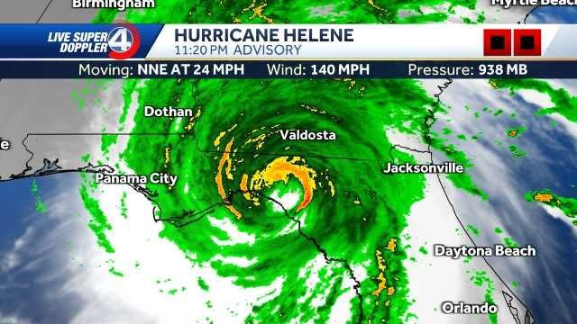
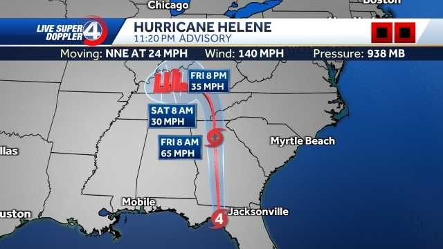
Right now, Helene is a Category 4 hurricane and is expected to downgrade back to a Cat. 3 after the storm makes landfall in Florida.
Helene is expected to be a Category 2 well inland and begin to further weaken after making it past southern Georgia.
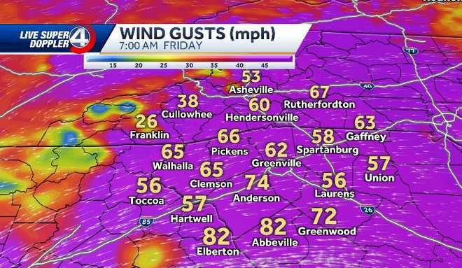
The storm is expected to bring wind gusts of more than 70 mph to the Upstate area of South Carolina, as well as heavy rain that will continue to shatter records.
Heavy rain and gusty winds are expected to cause flooding, downed trees and power outages. Tornadoes cannot be ruled out.
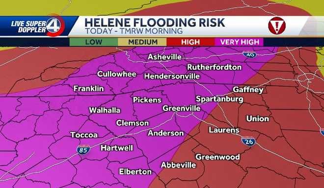
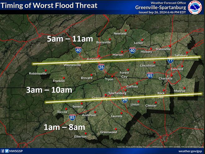
Flooding is going to continue to be a concern in much of the Upstate and Western North Carolina overnight. Areas in the Upstate could get an additional 2 to 3 inches of rain in areas east of Greenville and an additional 3 to 5 inches in areas west of Greenville. This is on top of the several inches that have already fallen.
After 10 pm Thursday, expect a 2-3 hour lull before conditions start to really pick back up.
Parts of Western North Carolina are expected to get an additional 4 to 7 inches on top of what’s already fallen.
Three-day-rain total records have been broken in many areas with officials calling it a “500 year historic flooding.”
A Tropical Storm Warning is in place through Saturday for our area. A Tropical Storm Warning is issued when Tropical Storm conditions, including winds of 39-73 mph, are expected in a specified area within 36 hours or less.
For the latest alerts in your area, click here.
Here is the latest timeline on what to expect:
Thursday night: Rain continues in our area with winds increasing. Winds will be between 30 to 40 mph with gusts around 45 mph. Helene is expected to landfall in Florida as category 4 on Thursday night.
Thursday night into Friday morning: Heavy rain continues as Helene races north. Winds will be between 30-40 mph with gusts of 70 mph. Concerns are flooding, downed trees and downed power lines as the core of the storm makes its way through our area.
Friday morning: The strongest winds will be early Friday morning between 30-40 mph with gusts of 50-60 mph. Rain continues. Concerns are flooding, down trees and downed power lines.
The storm moves out by late Friday morning.
Saturday: Partly sunny with temperatures in the upper 70s.