In the next few days il climate picture it will be maintained quite cold about our country, with the risk of frost in some regions.
From the harsh lands of the Arctic Circle, very cold winds are still flowing towards the Mediterranean basin, causing not only a worsening of the weather, but also a general drop in temperatures. The stormy winds, which are affecting numerous Italian regions, are making this feeling of cold worse, giving rise to the so-called wind chill, or “wind chilling index”.
THE WIND CHILL PHENOMENON: A THREAT TO BODY HEAT
This parameter describes the sensation of cold perceived by exposed skin, amplified by the combination of the real air temperature and wind speed.
Il wind chill occurs when the wind removes the layer of warm air that surrounds the skin, accelerating the loss of body heat. This phenomenon causes temperatures to be perceived as lower than the real ones. For example, in the presence of strong winds and already cold temperatures, the feeling of cold can be much more pronounced.
The calculation of this index uses formulas that integrate both the air temperature and wind speed: without wind, the perceived temperature corresponds to the real one; with the wind the effect significantly amplifies the thermal discomfort. In particular, values of wind chill very low increases the risk of hypothermia and frostbite, especially in conditions of prolonged exposure or inappropriate clothing. This risk is particularly high in high mountain areas, where, in winter, temperatures can drop several degrees below zero.
WEEKEND: STORMY WINDS AND WIDESPREAD FROSTS
During this weekend the climate picture will become even more severe. The cold winds coming from Northern Europe will hit almost all of Italy. Strong gusts of Mistral are expected on the Tyrrhenian side, while intense Bora and Grecale winds will blow along the Adriatic coast, particularly in the regions of Central Italy and Southern Italy.
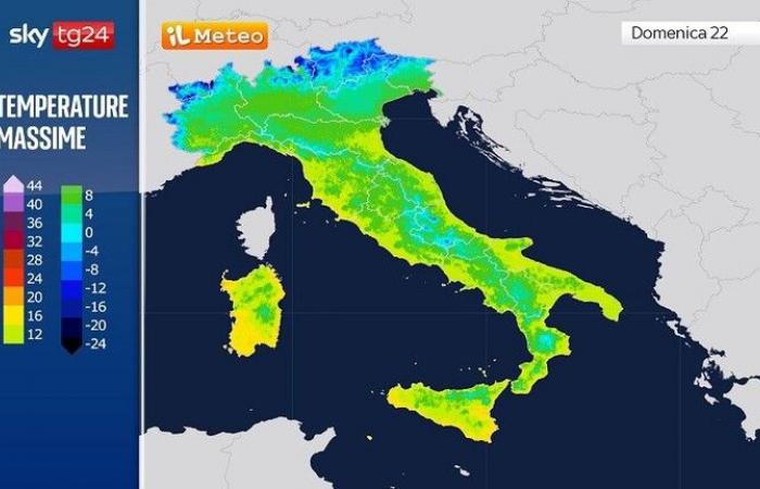
In the night between Saturday 21st and Sunday 22nd December, the temperature drop will be particularly marked. The greater clearings expected will favor a sudden drop in temperatures, with values of several degrees below zero in large areas of the Po Valley and in the internal valleys of Central Italy. Minimum temperatures will be particularly low on both Saturday and Sunday, with values close to or lower than 0°C in the internal areas of the North and Center. The highs, however, will remain at cool levels, between 5°C e 10°C to the North, and between 8°C e 13°C in the Center and the South.
No particular changes are expected in general circulation even on the days of Christmas holidaysas cold air masses will continue to hit our country, bringing widespread frosts in the North e cold bad weather on Central and Southern Adriatic regions.
FOR MORE INFORMATION: Christmas Week Weather: 23, 24 and 25 December with a bang, then big news from Boxing Day; the Trend


