Equipped with a powerful radar, a NASA plane has identified the remains of a former secret American base in Greenland.
Hundreds of meters of galleries and large-scale infrastructure are today under 30 meters of snow and ice.
The base was designed during the Cold War.
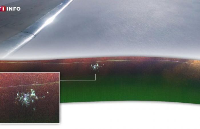
It’s a (re)discovery shared (new window) in recent days by NASA, carried out thanks to a plane flyover at high latitudes. Last April, a scientist from the American agency and a team of engineers were using a radar instrument to probe the Greenland ice cap from the air when he detected something unusual. Flying about 250 km east of the Pituffik base in the north of this vast Danish territory, Chad Greene took a photo from the plane’s window, showing the vast, barren expanse of the ice sheet’s surface . The radar then unexpectedly detected something buried in the ice.
“We discovered Camp Centuryslips Alex Gardner, cryosphere specialist at NASA, in a press release. At first we didn’t know what it was.” Also known as “city under the ice”these infrastructures are in fact a vestige of the Cold War. U.S. Army engineers built the military base in 1959 by digging a network of tunnels into the surface layer of the ice sheet. After its abandonment in 1967, snow and ice continued to accumulate, and solid structures associated with the facility today lie at least 30 meters below the surface.
Structures with very distinct shapes
The radar measures distance by sending radio waves and timing how long it takes for them to be reflected back from the sensor, NASA notes. Features that allow scientists to map the ice’s surface, its inner layers, and the bedrock beneath.
Thanks to the data collected during the flight conducted in April, the data highlighted “the structures of the secret city, visible as they had never been before”. If we compare the new radar map of Camp Century with historical maps of the base plan, the parallel structures appear to align with the tunnels built to house a whole series of installations, underlines the American agency.
-
Read also
Hot weather in Greenland: the melting of its glaciers contributes the most to rising water levels
From a scientific point of view, this discovery is of only limited interest, the researchers concede. Nevertheless, this is a “fairly unprecedented curiosity, observed by chance”. Officially presented at its construction as a center for research and studies on the Arctic, the base actually pursued a main objective “much more secret”underlines (new window) the newspaper Economic Times. It served as a testing ground for a project called “Iceworm” aimed at storing and possibly launching nuclear missiles from tunnels dug into the ice.
“The base housed between 85 and 200 soldiers and was powered by a nuclear reactor”added (new window) the American media USA Today. “It was abandoned in 1967 after the Joint Chiefs of Staff rejected the missile launch program. The U.S. Army Corps of Engineers removed the nuclear reaction chamber from the site, but left behind all the other infrastructure and all waste.”
In the future, this former military site could cause environmental problems. If the infrastructures are currently under snow and ice, climate change is likely to reveal them by 2100. A team of scientists estimates that 200,000 liters of diesel and 240,000 liters of wastewater are still present on the places. Not to mention an unknown volume of weakly radioactive coolant from the nuclear generator.


