AFP Videos – France
Hurricane Helene strengthens to category 3 before making landfall in Florida
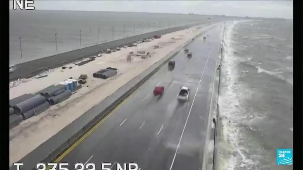
The “very dangerous” Hurricane Helene, now a “major” hurricane, is due to make landfall late Thursday in Florida, bringing with it “catastrophic” flooding that authorities have implored residents to take seriously. With winds of 195 km/h, Hélène strengthened into a category 3 hurricane on a scale of 5, according to the American Hurricane Center (NHC). It continues its route over the Gulf of Mexico towards the northwest of Florida, the third most populous state in the United States. It is expected to make landfall in the evening in the Tallahassee region, the state capital. , which has around 200,000 inhabitants. In this area, “no one has seen a storm of this magnitude in recent memory,” Florida Governor Ron DeSantis warned Thursday morning. He warned against falls of “I’m not going anywhere. I’m staying here. I’m going to retreat,” Patrick Riickert told AFP in Crawfordville, a small town located about thirty kilometers south of Tallahassee heading towards the coast. “I have confidence in my faith and the fact that God will protect me,” added this fifty-year-old, who will stay at home with his wife and grandchildren. Many residents fled after protecting the windows of their house from wooden planks, and most businesses have closed, noted AFP journalists on site. Further south still, at Alligator Point, at the water’s edge, David Wesolowski made final preparations before go take refuge with his family in Tallahassee. If the path of the hurricane remains unchanged, “it won’t look the same here afterwards, that’s for sure,” he said. – “Destructive” waves – The risk of marine submersion is particularly worrying, with a rise in water levels that could reach 6 meters in places on the coasts, or the height of a two-story building. This is a “scenario that is impossible to survive”, which will be accompanied by “destructive” waves that could sweep away houses and displace cars, warned Mike Brennan, director of the NHC, describing the hurricane as “very dangerous”. The winds, which could also be “catastrophic” according to this agency, will also affect the interior. The authorities therefore expect widespread power cuts. As of Thursday midday, around 80,000 customers were already without electricity in Florida, according to the poweroutage.us website. Several airports, notably those of Tallahassee and Tampa, are closed. – Debris – The particularity of Hélène is to be particularly extensive. Its size makes it “one of the largest hurricanes over the Gulf of Mexico this century,” noted expert Michael Lowry. Its impact will therefore be felt over a very large area. A state of emergency has been imposed in almost all of Florida’s 67 counties. Some 3,500 National Guard troops have been mobilized, with an additional 2,000 available if needed, DeSantis said. Federal funds have been released, with personnel ready to help with search and rescue operations, restoring power or clearing roads. “There’s going to be a lot of debris,” the governor warned. Food, water and generators have been pre-positioned, said Deanne Criswell, head of the federal disaster response agency (Fema). – Georgia, Tennessee, South Carolina – “This is going to be an event affecting several states,” she also warned. Beyond Florida, the states of Georgia, Tennessee and South Carolina will also see the effects of the hurricane, particularly the city of Atlanta and its five million inhabitants. Authorities there fear flash floods linked to heavy rains, as well as possible mudslides or landslides in the Appalachians. If several hurricanes have already hit the United States this year, including Béryl and Debby, they were less powerful than Hélène when they made landfall. The American Oceanic and Atmospheric Observation Agency (NOAA) had warned that the hurricane season this year – which extends from the beginning of June to the end of November – was expected to be particularly turbulent, particularly because of the heat of the oceans, which fuels these storms. By warming the waters of the seas, climate change makes more likely to intensify rapidly and increase the risk of more powerful hurricanes, scientists say. bur-la/cyb


