The frosts were marked and almost widespread this morning of Tuesday January 14, 2025. On a national scale, it was the coldest morning since February 28, 2018!
Several plains below -10°C
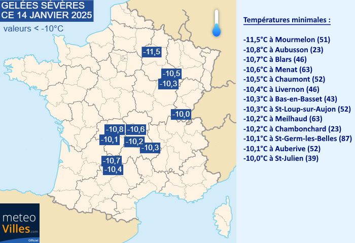
Temperatures were particularly low last night. As shown in the map below, the frost affected almost all of France this morning of Tuesday January 14, 2025, sparing only the islands of Finistère, the Côte d'Azur and Corsica. In many areas, the thermometer fell between -5 and -10°C with a few peaks below -10°C in plain regions. On the main network, it was in Rodez that it was the coldest with -10,2°C. We also noted -9,8°C in Luxeuil (70) and -9,6°C in Saint-Étienne (42).
Minimum temperatures for Tuesday January 14, 2025 – Weather Cities
As mentioned, several stations located in the plain sector (here below 500m) crossed the symbolic threshold of -10°C this Tuesday, January 14, 2025. It was in the Marne that it was the coldest with -11,5°C in Mourmelon-le-Grand! The southwest was not left out with a minimum of -10,7°C measured in Blars and -10,4°C in Livernon in the Lot. In Haute-Marne, we noted -10,5°C in Chaumont. Finally, we can note the -10,6°C of Menant in Puy-de-Dôme or the -10°C of Saint-Julien in the Jura.

Temperatures equal to or lower than -10°C this Tuesday, January 14, 2025 – Weather Cities
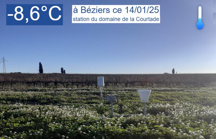
The severe frosts also affected the Mediterranean departments, particularly the hinterland. In Bouches-du-Rhône, the Marseille-Marignane airport station measured -3.9°C. A little further north, we measured -7,6°C in Salon-de-Provence. In Hérault, the station located at the Domaine de la Courtade measured -8,6°C and the thermometer dropped until -9,3°C in Saint-Martin-de-Londres!

-8.6°C measured in Béziers-Courtade (34) this Tuesday January 14, 2025 – Weather France
The coldest morning in 7 years!
The national thermal indicator is calculated based on measurements from old weather stations distributed equally across the four corners of France. This morning of Tuesday January 14, 2025, the latter displayed a value of -4,6°C ! This is quite simply the lowest value since the -7.7°C measured on the morning of February 28, 2018, i.e. almost 7 years ago ! Suffice to say that such a marked and widespread frost does not happen every day, especially in recent years.
The national thermal indicator reached its lowest level since February 28, 2018 – Weather Cities
-This statistic is all the more significant as the last morning colder than that of the day took place during the last cold wave which affected France >>> Indeed, the cold wave thresholds had been reached on the 26 as of February 28, 2018. He had done up to -14°C in Luxeuil, Saint-Étienne and Aurillac. However, the -7.7°C in the morning of 02/28/2018 remains far from the -4.6°C of that day. In addition, we are not experiencing a cold spell for the simple reason that it thaws quite widely over almost the entire country. Daytime values are not low enough.
Edges of Lake Geneva frozen in ice in Versoix (Switzerland) on February 28, 2018 – Benjamin Daujat / Planète Météo
(Almost) all conditions were met
It must be said that last night offered conditions that were particularly conducive to falling temperatures and severe frosts. We are currently concerned by a radiation freeze (or radiative freeze), induced by a thermal inversion. This means that the lower layers of the atmosphere are colder than the upper layers. This is due to the loss of terrestrial heat through irradiation during the night, which typically occurs under anticyclones. However, pressures are currently very high, rising to 1036 hPa in the northwest.
Atmospheric pressure this Tuesday January 14, 2025 – Weather Cities
This radiative freeze also requires absent cloud cover to occur. Indeed, this condition is essential to authorize the loss of terrestrial heat by irradiation. However, conditions were almost optimal in France last night. As shown in the satellite image of this Tuesday, January 14, 2025, a large part of French territory woke up under clear skies. This lack of cloud cover, coupled with often very weak wind, considerably accentuated the radiation and cooling near the ground.
Satellite image of Tuesday January 14, 2025 in the morning – EUMETSAT
The only condition that was not present to amplify the frost was the presence of snow on the ground. Apart from certain areas of Nord-Pas-de-Calais and Belgium, no lowland region is currently snow-covered. If this had been the case, we would have been entitled to even lower values because the snow on the ground amplifies the nighttime radiation and the cooling of the air layer located near the ground.
Related News :
