A fast and very active ocean current will concern the Atlantic and Western Europe for several days. France will be at the forefront of these bad weather with episodes of strong wind and abundant rain.
What are the regions most exposed to heavy rains?
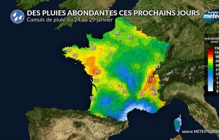
The northwest regions are the first to undergo an episode of heavy rain on Friday, extending the following night. Brittany, the Loire" rel="tag">Pays de la Loire and Basse-Normandie will be affected with bumps for rain from 20 to 30 mm, locally up to 50 mm between Morbihan and Loire-Atlantique. This precipitation corresponds to ten days of rain in the space of 24 hours. Note that a lull will intervene on Saturday before new rains will return to these regions on Sunday, bringing an additional 10 to 15 mm.
Cumulative rain previewed between Friday and Saturday © The weather channel
With saturated floors and the low soil evaporation at this time of the year, rivers will react with floods on many rivers with a risk of floods in places.
After the northwest regions, the east regions and the western slopes of the Massif Central will in turn undergo strong precipitation. Active disturbances will follow one another at the rate of one per day between Sunday and next Thursday. The accumulation of rain will become important from the Vosges and the Franche-Comté at Auvergne-Rhône-Alpes with 30 to 50 mm in the plain on average and 60 to 90 mm on the reliefs, locally more than 100 mm. The snow rain limit will fluctuate a lot in the mountains according to significant variations in temperatures.
Abundant rains in the coming days © The weather channel
Should we fear important floods and floods?
-With soils often saturated with water and the low evaporation of the soils at this time of the year, rivers will react in the regions which will undergo repeated rains. In Brittany, Pays de la Loire, floods will concern many rivers with a risk of floods in places. Rivers like the Vilaine, the Blavet or the Sèvre Nantes will be able to experience important floods since we expect on their watersheds, the equivalent of three weeks of rain in a few days. These rains will be added to the cumulatives of rain significantly fallen during the first decade of January.
In Nantes, it has already fallen 101 mm since the beginning of the month while the normal in January is 88 mm. With a combination of rain which should reach 70 to 80 mm by the end of the month, the rainfall of this month of January could correspond to double normal.
In the East, some regions have also received a lot of rain at the beginning of January and will undergo new abundant rains in the coming days. There too the floors are still very humid on the surface and the new precipitation will quickly reach the rivers. In Chambéry, it fell 116 mm since January 1 for a normal 103 mm. The abundant rains planned in the coming days (80 mm) should lead to rainfall equivalent to double a usual month of January.
With such a hydrological and meteorological situation, floods and floods are likely to be talked about in the east and in particular at the foot of the reliefs under the combined effect of rains and periods of melting snow, in connection with periods significant redoux.
Can we hope for an improvement and the return of a drier time?
After the very disturbed time of this end of January, the return of quieter and anticyclonic weather conditions is expected for the beginning of February, as envisaged by our weather trend for the next 4 weeks. Reliability is good enough to find this period of calm and dry time but reliability is still limited as to the duration of this improvement.


