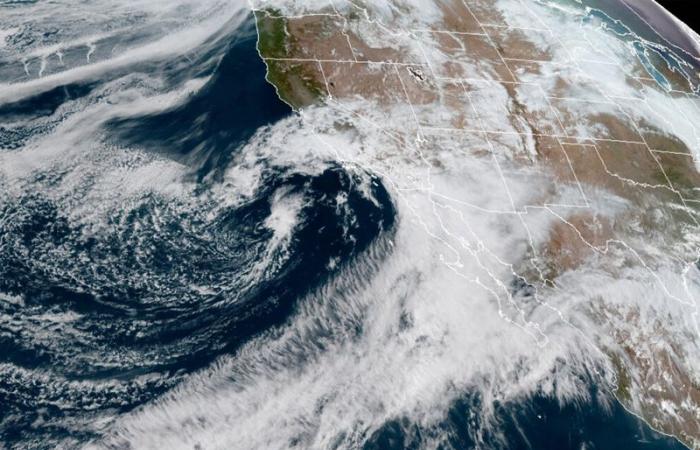
Northern California and the Pacific Northwest are preparing for an impending powerful storm, expected to bring heavy rain and strong winds, potentially leading to power outages and flash floods.
The Weather Prediction Center has issued warnings for excessive rainfall starting Tuesday and continuing through Friday. This forecast comes as the region faces its strongest atmospheric river of the season—a vast plume of moisture extending over the Pacific Ocean.
The storm has intensified rapidly, earning the designation of a “bomb cyclone,” according to Richard Bann, a meteorologist at the National Weather Service Weather Prediction Center.
Severe rainfall is anticipated from south of Portland, Oregon, to north of the San Francisco area as the moisture-laden plume approaches the coast, Bann explained.
He stated, “Be aware of the risk of flash flooding at lower elevations and winter storms at higher elevations. This is going to be an impactful event.”
In northern California, flood and high wind watches will be in effect from Tuesday, with up to 8 inches (20 centimetres) of rain expected in parts of the San Francisco Bay Area, North Coast, and Sacramento Valley.
A winter storm watch has been issued for the northern Sierra Nevada above 3,500 feet (1,066 metres), where up to 15 inches (28 centimetres) of snow is possible over two days. Wind gusts in mountainous areas could exceed 75 mph (120 kph), according to forecasters.
The Weather Prediction Center warned that “numerous flash floods, hazardous travel, power outages, and tree damage can be expected as the storm reaches max intensity” on Wednesday.
Meanwhile, Southern California will experience dry conditions and gusty Santa Ana winds, which could increase wildfire risk in areas still recovering from a major blaze that destroyed 240 structures. The Mountain Fire, which began on 6 November in Ventura County northwest of Los Angeles, was about 98% contained as of Monday.
Winds are expected to subside by the end of the week, with rain possible in the greater Los Angeles area.
In southwestern Oregon, near the coast, 4 to 7 inches (10 to 18 centimetres) of rain is forecasted through late Thursday night and early Friday morning, with some areas potentially receiving up to 10 inches (25 centimetres), Bann reported.
A high wind warning is in effect for the north and central Oregon coast from 4 p.m. Tuesday, with south winds ranging from 25 mph (40 kph) to 40 mph (64 kph) and gusts up to 60 mph (97 kph). Beaches and headlands could see gusts up to 70 mph (113 kph). Widespread power outages are anticipated due to the winds’ potential to topple trees and power lines, according to the weather service in Portland. Travel is also expected to be difficult.
Washington could also experience significant rainfall, though not as severe as Oregon and California. Some coastal areas in Washington may receive up to 1.5 inches (3.8 centimetres) of rain from Monday evening through Tuesday, Bann noted.
The weather service has issued high wind warnings for coastal parts of Pacific County, southwest Washington, from Tuesday afternoon until early Wednesday, with gusts potentially exceeding 35 mph (46 kph) and higher speeds near beaches and headlands, posing a risk to trees and power lines, according to the Pacific County Emergency Management Agency.
Elsewhere, the central and eastern Gulf Coast, including the Florida Panhandle, is at risk of flooding on Tuesday, with 2 to 3 inches (5 to 7.6 centimetres) of rain forecasted, potentially causing flash floods in low-lying and urban areas.
Follow us on:


