Play
- A powerful storm off the Northwest coast is dragging in an atmospheric river of moisture.
- Heavy rain could trigger flooding, mudslides and rock slides, especially in Northern California and southwest Oregon.
- Strong winds will accompany the storm and higher elevations will see feet of snow.
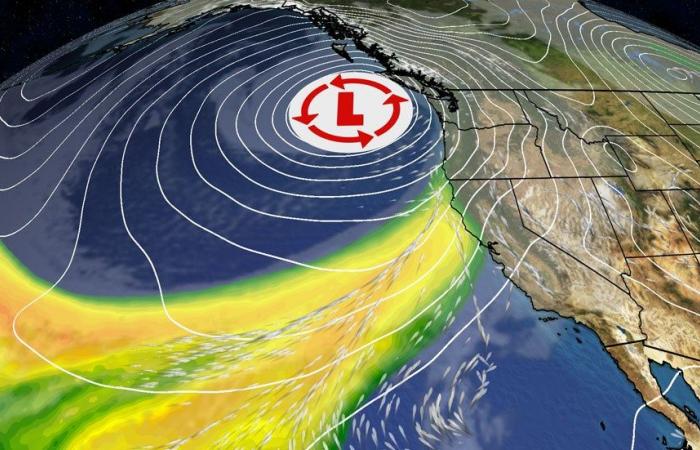
A powerful low-pressure system known as a “bomb cyclone” has intensified off the West Coast as it ushers in a strong, long-duration atmospheric river to the region, which is likely to produce flooding rain, feet of snow and high winds through the end of the week.
(MORE: Bomb Cyclones 101)
Rapidly-Intensifying Storm Kicks Off Soaking Pattern
The storm has easily met the criteria for what meteorologists call bombogenesis, which is where the term “bomb cyclone” originates from. That means its pressure has dropped by 24 or more millibars in 24 hours or less, indicative of a storm that is intensifying quickly, which can result in more significant impacts than what a weaker storm would produce.
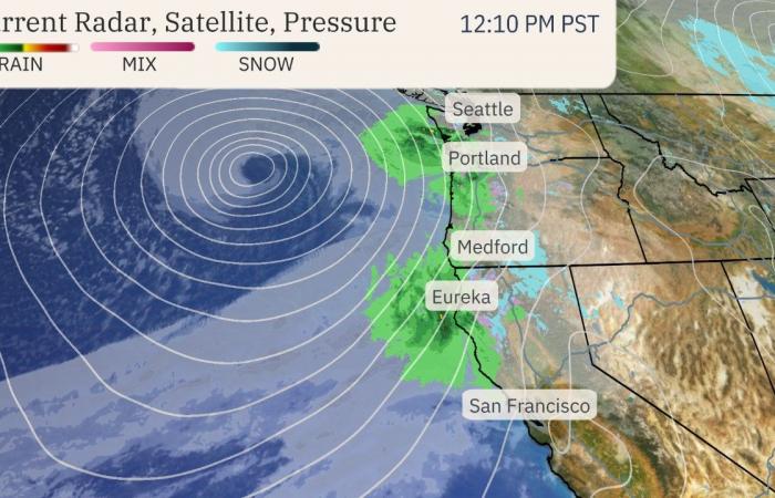
You can see that storm near the Northwest coast in the current radar, satellite and surface pressure snapshot below.
The storm is also hauling in a long-lasting atmospheric river moisture plume that is packed with copious amounts of rain and mountain snow, especially in Northern California and parts of Oregon.
Peak impacts from this soaking pattern will unfold through Friday, possibly lingering into the weekend for some.
(MORE: Atmospheric Rivers 101)
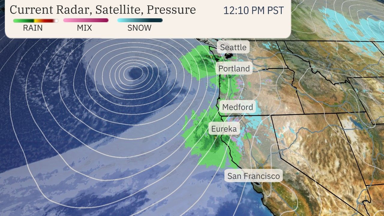

Current Radar, Satellite And Pressure
Breaking Down The Impacts
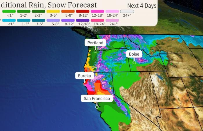
Heavy Rain – The biggest rainfall totals through the end of the workweek will take aim at Northern California (north of the Bay Area) into southwest Oregon. Some areas could pick up 8 to 12 inches of rain (locally up to 15 inches) in this region.
The heavy rain will result in flooding for poor drainage areas as well as possible flooding on creeks and rivers. Mudslides could be a threat too, especially in any recent wildfire burn areas. Rock slides are possible along some mountain roads, as well.
A rare high risk excessive rainfall outlook has been issued by NOAA’s Weather Prediction Center in northwest California on Thursday, including Eureka, because of how serious the flood threat could be in that area.
Elsewhere, totals of 1 to 5 inches will extend northward through the rest of western Oregon and western Washington, with the heaviest amounts in coastal and foothill locations.
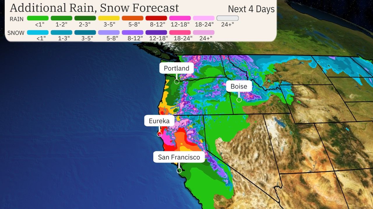

Additional Rain And Snow Forecast
Snowfall – With moisture funneling into the Northwest day after day, snow will be measured in feet from the higher elevations of the Cascades southward into the Siskiyou and Sierra mountains of Northern California. Snow levels will start out low but then rise through the week, impacting travel in some passes.
Snowfall and strong winds at times will impact Washington’s Snoqualmie Pass along Interstate 90 and Siskiyou Pass along Interstate 5 near the Oregon and California border.
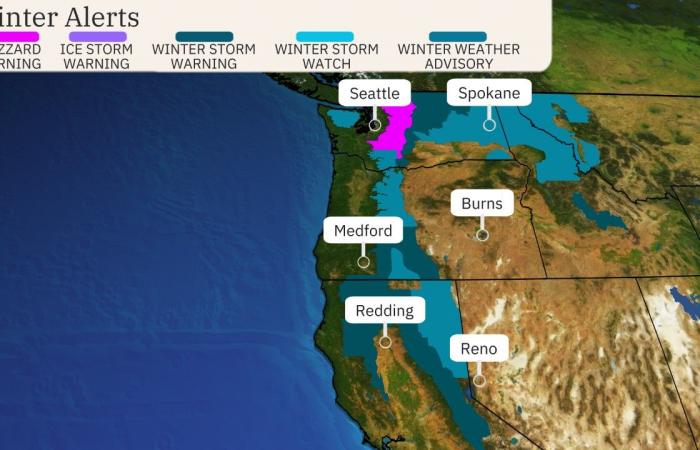
The National Weather Service has issued various winter weather alerts from the Cascades to California’s northern Sierra. That includes a blizzard warning in the Washington Cascades for late Tuesday into early Wednesday, where travel is highly discouraged.
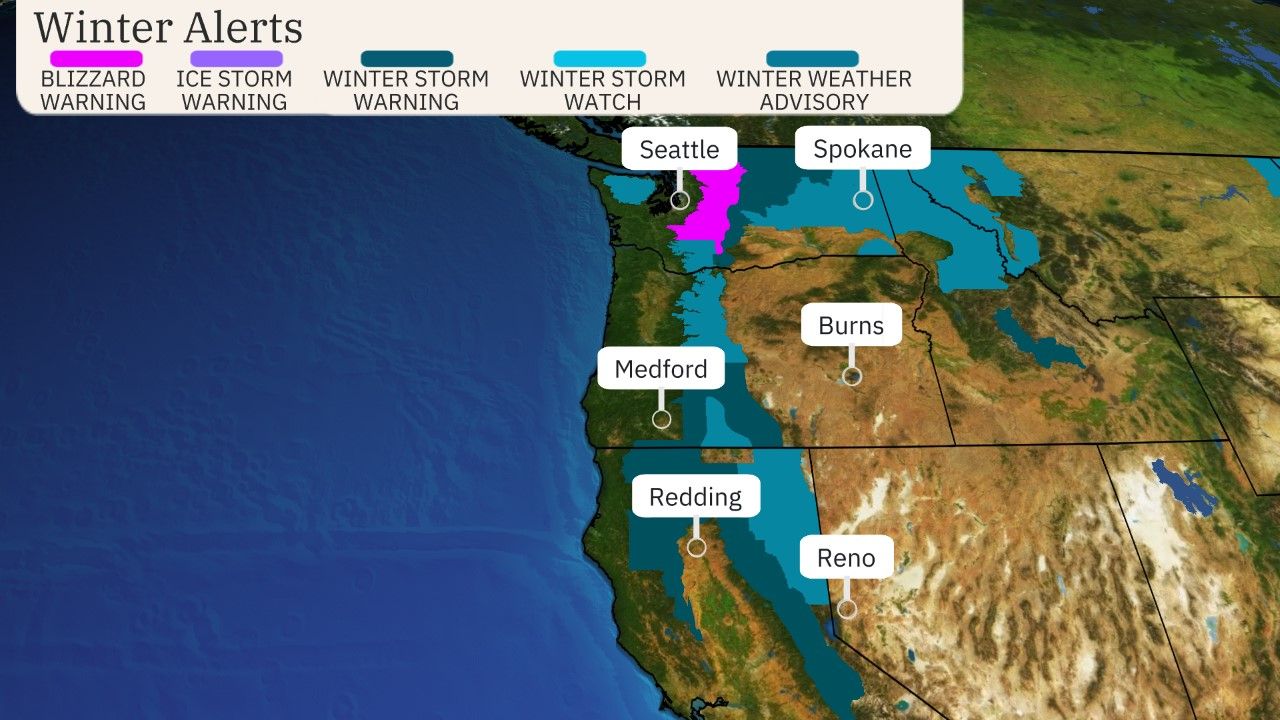

Winter Weather Alerts
(Issued by the National Weather Service.)
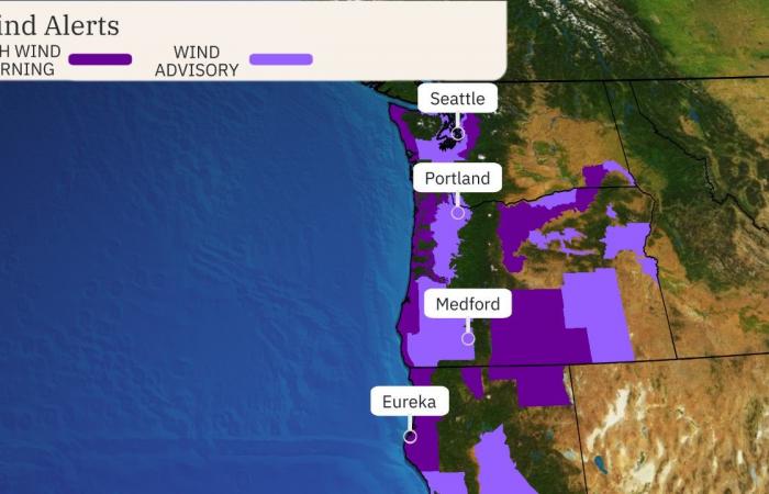
High Winds – The strongest bout of winds from this storm pattern will arrive later Tuesday and last into early Wednesday. Coastal parts of Northern California, Oregon and Washington might see gusts over 60 or 70 mph at times. Stronger gusts will also affect inland areas through the Cascades and its foothills.
Some power outages and downed trees are possible impacts, especially in areas under high wind warnings in the map below.
There could be another bout of stronger winds arriving by early Friday, but regardless, winds will be gusty at times the rest of this week.
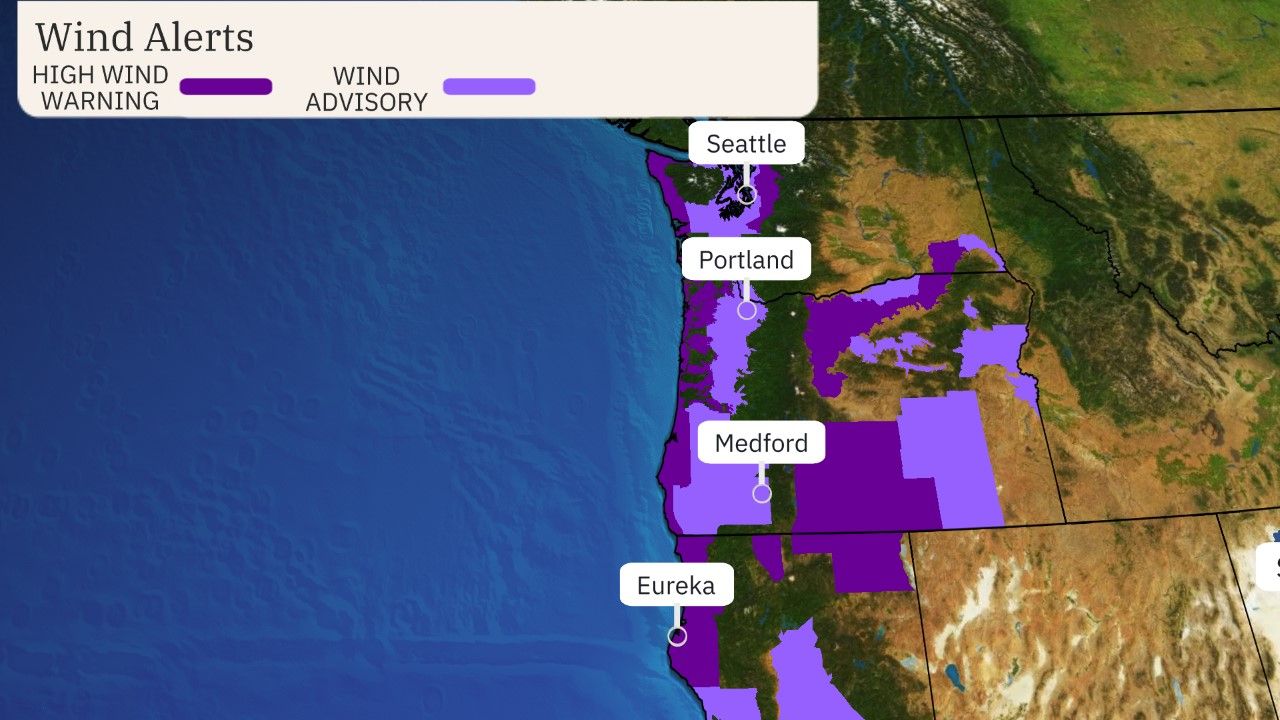

Wind Alerts
(Issued by the National Weather Service.)
Chris Dolce has been a senior meteorologist with weather.com for over 10 years after beginning his career with The Weather Channel in the early 2000s.

