The fall clash of seasons will be apparent this week across the U.S. as a mix of severe storms, wintry weather, and wild temperature swings make for an active stretch of weather for millions of Americans.
On Monday, widespread precipitation and heavy mountain snow is expected across the Northwest and northern Rockies, the National Weather Service said. Up to a foot of snow is possible across the higher elevations of the Cascades and northern Rockies, wreaking travel havoc for motorists who are venturing out.
And in the central U.S., thunderstorms forming along a cold front could contain damaging winds and perhaps a few tornadoes between central Oklahoma and North Texas Monday afternoon and evening.
Meanwhile, elsewhere, some of the coldest air of the season is poised to overspread much of the central, southern, and eastern U.S. later in the week: “This colder air should arrive in the Plains around Wednesday, then quickly spill over the rest of the South, lower Midwest and East Thursday,” said Weather.com meteorologist Jonathan Erdman in an online report. “It will likely hang in through the weekend,” he added.
‘Appetizer of precipitation’ Monday in the West; freeze warning in Calif.
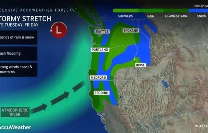
For much of the Northwest, northern Great Basin, and northern Rockies, a cold front pushing across the region today will allow for unsettled weather to continue ahead of another powerful storm system that’s forecast to develop off the coast of the Northwest on Tuesday, the weather service said.
“This appetizer of precipitation to start the workweek will mainly include the potential for moderate to heavy snowfall across the Cascades and northern Rockies,” said weather service meteorologist Cody Snell in an online forecast.
The weather service warned that due to the snow, roads, and especially bridges and overpasses, will likely become slick and hazardous throughout Monday and into Tuesday: “Plan on slippery road conditions. If you must travel, keep an extra flashlight, food, and water in your vehicle in case of an emergency.”
In California, forecasters warned of a hard freeze for much of the central valley for Monday evening: “Frost and freeze conditions could kill crops, other sensitive vegetation and possibly damage unprotected outdoor plumbing,” the weather service in Sacramento warned.
An atmospheric river will bring several days of stormy weather to the Northwest this week, forecasters said.
Tornadoes, heavy rain possible in central U.S.
The threat for a few tornadoes and damaging winds will exist Monday afternoon and evening from parts of east Texas into Louisiana and vicinity, the Storm Prediction Center said.
A tornado watch will likely be need to be hoisted later Monday for portions of Texas and Louisiana, meaning conditions will be ripe for tornadoes to form.
In addition to the tornado threat, heavy rainfall is most likely Monday night across eastern Louisiana and southern Mississippi, with the threat expanding east to the Florida Panhandle on Tuesday, the weather service said.
Winter approaches, hurricane season ends
A major storm is brewing for midweek around the Great Lakes that may not only bring wintry changes to much of the eastern U.S. but could bring some much-needed rain, AccuWeather meteorologists say.
How cold will it get later in the week? Erdman said low temperatures in the 30s and 40s will be common in the South, and even Florida may have some chilly mornings in the 40s and 50s. Meanwhile, highs in the 40s and a few 30s will be the rule in the Midwest and interior Northeast, he said.
With the chilly push of air comes good news from the tropics: “One thing the big Midwest storm and its spread of colder air into the South and East later this week will do will be to effectively end the risk of any tropical storms from making landfall in the U.S.,” AccuWeather senior meteorologist Brett Anderson said. “There may still be some tropical activity over part of the Atlantic basin, but that would likely be deep into the tropics or over the central Atlantic and not near the U.S.”
Tropical Storm Sara dissipated over the Yucatan Peninsula Monday morning. The official end of hurricane season is Nov. 30.
This article originally appeared on USA TODAY: Wild weather forecast: Snow, tornadoes, temp swings likely


