Video above: Latest coverage on the tropicsEven though most models agree on Tropical Depression Sara’s clear path toward Central Florida this week, there’s no need to panic.According to recent data from the National Hurricane Center, the system’s interaction with land and an oncoming cold front is forecast to weaken the storm before it approaches the state.While rain coverage could take a stark jump midweek, there’s little concern about a significant system moving through Florida.Where is Sara now?Currently located 125 miles from Campeche, Mexico, Sara has maximum sustained winds of 30 mph and a minimum central pressure of 1004 MB.On Saturday, the NHC said Sara was stationary off the northern coast of Honduras, bringing heavy rain. Tropical Depression Sara is expected to move inland over the Yucatan Peninsula before weakening into a remnant low. By Monday, Sara is expected to approach the Gulf of Mexico, swing toward Florida and move tropical moisture into the state by Wednesday. What is Sara’s projected path?After turning northwestward through Belize and portions of Mexico, Sara is expected to emerge into the Gulf of Mexico. Once in the Gulf, Sara is expected to continue on a northern path before turning to the east, putting Florida in the direct path of this system.Sara’s major steering factor will be the speed of a front moving across other Gulf Coast states like Texas, but the front will also create conditions that are unfavorable for the already weak system to develop further. By the time Sara makes it to Florida, it’s forecast to just be a remnant low or some tropical moisture.While rain chances will notably increase around Wednesday, the threat of a significant storm is extremely low.WESH 2 will continue to monitor this system’s development and model data and bring you the latest. Related: WESH 2 Hurricane Survival Guide 2024Related: Surviving the Season | 2024 Hurricane Special from WESH 2Sara watches, warningsThere are no coastal watches and warnings in effect. First Warning WeatherStay with WESH 2 online and on air for the most accurate Central Florida weather forecast.RadarSevere Weather AlertsDownload the WESH 2 News app to get the most up-to-date weather alerts.The First Warning Weather team includes First Warning Chief Meteorologist Tony Mainolfi, Eric Burris, Kellianne Klass, Marquise Meda and Cam Tran.
Video above: Latest coverage on the tropics
Even though most models agree on Tropical Depression Sara’s clear path toward Central Florida this week, there’s no need to panic.
According to recent data from the National Hurricane Center, the system’s interaction with land and an oncoming cold front is forecast to weaken the storm before it approaches the state.
This content is imported from Twitter.
You may be able to find the same content in another format, or you may be able to find more information, at their web site.
While rain coverage could take a stark jump midweek, there’s little concern about a significant system moving through Florida.
Where is Sara now?
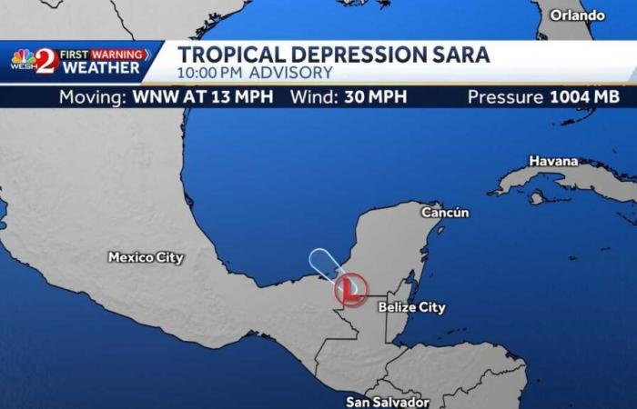
Currently located 125 miles from Campeche, Mexico, Sara has maximum sustained winds of 30 mph and a minimum central pressure of 1004 MB.
On Saturday, the NHC said Sara was stationary off the northern coast of Honduras, bringing heavy rain.
This content is imported from Twitter.
You may be able to find the same content in another format, or you may be able to find more information, at their web site.
Tropical Depression Sara is expected to move inland over the Yucatan Peninsula before weakening into a remnant low.
By Monday, Sara is expected to approach the Gulf of Mexico, swing toward Florida and move tropical moisture into the state by Wednesday.
What is Sara’s projected path?
After turning northwestward through Belize and portions of Mexico, Sara is expected to emerge into the Gulf of Mexico.
Once in the Gulf, Sara is expected to continue on a northern path before turning to the east, putting Florida in the direct path of this system.
This content is imported from Twitter.
You may be able to find the same content in another format, or you may be able to find more information, at their web site.
Sara’s major steering factor will be the speed of a front moving across other Gulf Coast states like Texas, but the front will also create conditions that are unfavorable for the already weak system to develop further. By the time Sara makes it to Florida, it’s forecast to just be a remnant low or some tropical moisture.
While rain chances will notably increase around Wednesday, the threat of a significant storm is extremely low.
WESH 2 will continue to monitor this system’s development and model data and bring you the latest.
Related: WESH 2 Hurricane Survival Guide 2024
Related: Surviving the Season | 2024 Hurricane Special from WESH 2
Sara watches, warnings
There are no coastal watches and warnings in effect.
First Warning Weather
Stay with WESH 2 online and on air for the most accurate Central Florida weather forecast.
Download the WESH 2 News app to get the most up-to-date weather alerts.
The First Warning Weather team includes First Warning Chief Meteorologist Tony Mainolfi, Eric Burris, Kellianne Klass, Marquise Meda and Cam Tran.
Belgium


