I. Situation Overview
Issued on 14 November 2024 at 5:00 AM, Typhoon “Ofel” further intensifies and is nearing Super Typhoon category.
HAZARDS AFFECTING LAND AREAS
Heavy Rainfall Outlook
Refer to Weather Advisory No. 28 issued at 5:00 AM today for the heavy rainfall outlook due to “OFEL”.
Severe Winds
The wind signals warn the public of the general wind threat over an area due to the tropical cyclone. Local winds may be slightly stronger/enhanced in coastal and upland/mountainous areas exposed to winds. Winds are less strong in areas sheltered from the prevailing wind direction
• Significant to severe impacts from typhoon-force winds are possible within any of the areas under Wind Signal No. 4.
• Moderate to significant impacts from gale-force winds are possible within any of the areas under Wind Signal No. 3.
• Minor to moderate impacts from strong winds are possible within any of the areas under Wind Signal No. 2.
• Minimal to minor impacts from strong winds are possible within any of the areas under Wind Signal No. 1
The highest Wind Signal which may be hoisted during the occurrence of “Ofel” is Wind Signal No. 5. Coastal Inundation There is a moderate to high risk of life-threatening storm surge with peak heights reaching 1.0 to 3.0 m in the next 48 hoursover the low-lying or exposed coastal localities of Batanes, Ilocos Norte, Ilocos Sur, Cagayan including Babuyan Islands, Isabela,and northern Aurora. Refer to Storm Surge Warning No. 7 issued at 2:00 AM today for the details.
HAZARDS AFFECTING COASTAL WATERS
24-Hour Sea Condition Outlook
Up to very rough or high seas over the following coastal waters:
● Up to 10.0 m: The eastern seaboard of mainland Cagayan; the seaboard of Babuyan Islands
● Up to 8.0 m: The seaboards of Isabela; the remaining seaboard of mainland Cagayan
● Up to 7.0 m: The seaboard of Batanes
● Up to 4.5 m: The seaboard of northern Aurora; the northern seaboard of Ilocos Norte
● Sea travel is risky for all types or tonnage of vessels. All mariners must remain in port or, if underway, seek shelter or safe harbor as soon as possible until winds and waves subside.
Up to rough seas over the following coastal waters:
● Up to 3.5 m: The remaining seaboard of Aurora; the seaboard of northern Quezon; the northern and eastern seaboard of Polillo Islands; the western seaboard of Ilocos Norte
● Up to 3.0 m: The northern and eastern seaboards of Catanduanes; the seaboards of Camarines Norte; the northernseaboard of Camarines Sur
● Mariners of small seacrafts, including all types of motorbancas, are advised not to venture out to sea under these conditions, especially if inexperienced or operating ill-equipped vessels.
Up to moderate seas over the following coastal waters:
• Up to 2.5 m: The eastern seaboard of Quezon including the rest of Polillo Islands; the eastern seaboards of Albay and Sorsogon
• Up to 2.0 m: The remaining seaboard of Ilocos Region; the remaining seaboard of Catanduanes and Camarines Sur and Eastern Samar; the northern and eastern seaboards of Northern Samar; the eastern seaboard of Eastern Samar
• Mariners of motorbancas and similarly-sized vessels are advised to take precautionary measures while venturing out to sea and, if possible, avoid navigation under these conditions.
TRACK AND INTENSITY OUTLOOK
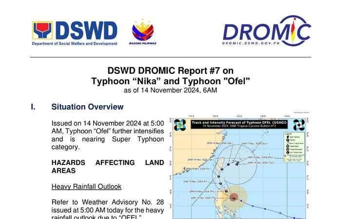
● “OFEL” is forecast to move northwestward over the Philippine Sea before making landfall along the eastern coast of Cagayan or northern Isabela this afternoon. It will then emerge over Babuyan Channel tonight while making another landfall or passing close to Babuyan Islands. OFEL will then turn north northwestward to north northeastward over the sea west of Batanes by tomorrow (November 15) before turning northeastward beginning Saturday (16 November) over the sea east of Taiwan towards Ryukyu Islands by the remaining forecast period.
● Regardless of the position of the landfall point, it must be emphasized that hazards on land and coastal waters may still be experienced in areas outside the landfall point and the forecast confidence cone. Furthermore, the track may still shift within the limit of the forecast confidence cone, especially the portion wherein OFEL will be moving northeastward
● OFEL will continue to intensify within 12 hours and possibly make landfall during its peak intensity. Given that the tropical cyclone is now traversing in a more favorable environment, its probability of reaching super typhoon category is not ruled out. A weakening trend may ensue once OFEL reaches Taiwan until it weakens into a remnant Low over Ryukyu Islands by Monday or Tuesday
The center of the eye of Typhoon OFEL was estimated based on all available data including those from Baler and Daet Weather Surveillance Radars at 215 km East of Echague, Isabela (16.7 °N, 123.7 °E) while Moving West Northwestward at 30 km/h with maximum sustained winds of 165 km/h near the center and gustiness of up to 205 km/h.
Source: DOST-PAGASA Tropical Cyclone Bulletin #7


