The question is no longer whether France will be affected by the remains of Hurricane Kirk. It is certain that the country is right in the axis of this meteorological monster at the end of its life. Only the intensity and the precise schedule remain to be refined.
By Monday, Kirk will be located at the latitude of Bordeaux (Gironde). This has two consequences. The first is that at this height in the North Atlantic, the surface water temperature is lower than in the tropics. It is currently around fifteen degrees, according to data from the American Hurricane Center, the NHC. It would take about ten degrees more to keep Kirk fueled. The other consequence is that the phenomenon is taken up and carried away by the powerful altitude currents dominant in this part of the hemisphere.
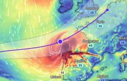
These two elements added together contribute to a rapid weakening of the hurricane. By the time it reaches France, it will have lost its tropical characteristics, which are its most violent markers, and will no longer be anything other than a classic autumn storm. The impact should be gradual overnight from Tuesday to Wednesday, as shown in this NHC map.
Kirk’s remains are expected to cross France on Wednesday on an axis stretching from Gironde to the country’s northeastern borders for the most affected area. It is near Belgium, Luxembourg, the Netherlands and north-west Germany, which it should reach on Thursday, that the storm would once again become a simple depression. Île-de-France could be covered by the heart of this system.
Thursday in bad weather
Precipitation will be significant from Tuesday night to Wednesday. If the south of the country will be spared initially, it will be affected by bad weather during the night from Wednesday to Thursday due to the significant tailing sky which will follow the passage of the remains of Kirk, according to the ECMWF, the Center European for medium-term weather forecasts. The Météo France map for Thursday is particularly eloquent. The situation should calm down by the end of the day.

One of the questions that remains without a precise answer is that of the strength of the wind. Will they be stormy, that is to say around 100 km/h inland and 120 km/h – 130 km/h on the coasts and at sea? Or will Kirk’s remains have lost enough power to ultimately become nothing more than a depression once in France? In this second, more optimistic hypothesis, the gusts would in all cases be at levels close to those of a storm.
Strong gusts
For the moment, Météo France anticipates gusts of 95 km/h in Charente-Maritime on Wednesday evening. At the same time, they would only be 60 km/h to 70 km/h inland. The story is different from The Weather Channel, which is based on another weather model, the American GFS which has tended in 2024 to be more reliable than in recent years. The gusts would reach or even exceed the threshold of the storm from Charente to the Ardennes via the east of Île-de-France with peaks around 110 km/h. From the southwest to the northeast of the country the speed would exceed 90 km/h.

Storm or depression, whatever. With such values, great caution is required. These bursts will occur during the week, during the day or early evening, at a time when people are moving around, especially on a Wednesday, when many children have activities. The event also occurs at a time of year when the trees still have many leaves. They therefore have more resistance to the wind and are therefore more easily uprooted.