Par
Alexandra Second
Published on
Nov 19 2024 at 5:04 p.m
See my news
Follow News
THE first showers and the first big snowfall : the days of Wednesday 20 and Thursday 21 November 2024 promise to be very wintery, at altitude as well as in the plains.
It is also not a question of a few flakes, but of a pretty white coat a few centimeters, or even more than a meter on the massifs. Here are the snowfall accumulations that could be expected over the next few days.
“Anecdotal” accumulations in the north of France
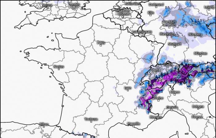
Thus, on Wednesday, the first snowflakes will mainly affect the northern tip of Franceas can be seen on the European weather model ECMWF. There Normandie is the most concerned, “perhaps also Île-de-France», indicates to actu.fr meteorologist Guillaume Séchet.
How to read our cards?
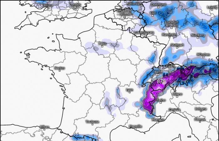
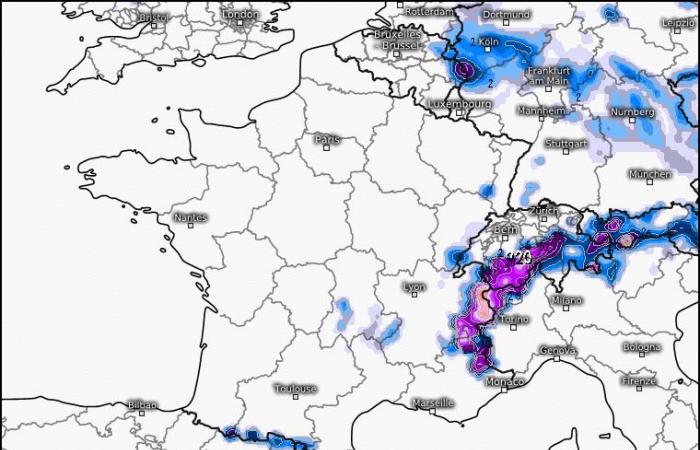
These maps anticipate the snowfall expected in France according to digital models, which analyze the movement of air masses, atmospheric pressure, etc. The color gives an indication of the accumulation (from gray to purple) of snow in a given territory.
Please note, these maps are forecasts and only give estimates. As snow is very difficult to predict, these data are likely to change completely by Thursday.
But in these regions where rain is also likely to come (and prevent the snow from sticking to the ground), the snow accumulations look “fairly anecdotal”, insists the founder of the site meteo-villes.com.
Heavier snow in mountain areas
On the other hand, we observe heavier snowfall in mountainous areas logically, “with a rain/snow limit which drops to 1000/1200 meters, compared to 1200/1300 meters at the start of the week”, explains meteorologist Yann Amice, also contacted by actu.fr.
Snow will fall scatteredly on Wednesday Massif centralbut also (in order of expected accumulations) on the center of the Pyrenees, and part of the Vosges.
However, the snow will arrive more “abundantly” in the Alps on a line between the Nice hinterland, Digne-les-Bains, Gap, Grenoble, Chambéry, Annecy. We could have up to 50 cm of snow on the Alps, Météo France figure.
Several centimeters of snow on the plain
The bulk of the snow remains to be monitored for the day of Thursday, November 21, 2024. The cold which persists and the precipitation which is expected “maintains a rain/snow limit between Brittany, Pays de la Loire, Center, Burgundy, Franche-Comté and the Rhône-Alpes area,” lists Guillaume Séchet.
Orléans, Dijon, Limoges, around Rennes… Snowflakes could become more frequent over a larger part of the territory. “In the plains, we wait two to three centimeters
in the most exposed areas, on the Brittany / Normandy / Île-de-France / Rhône-Alpes corridor,” continues the meteorologist.
Perhaps more along a corridor between Brittany, Île-de-France and the Rhône-Alpes area, where there could be three to five centimeters of snow.
The Massif Central will be able to accommodate “10 to 15 cm of snow”as well as the Vosges. The biggest accumulations are expected, again for the Alps: it could fall “ approximately 1.65 m of snowthe first big snowfall in the Alps,” underlines the meteorologist.
Different scenarios depending on the weather models
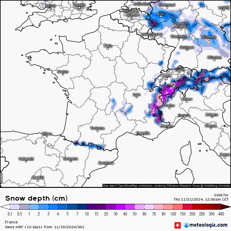
Depending on the models (between Thursday morning and Friday afternoon), snow accumulations vary, as well as the areas where flakes are expected. The German ICON model provides for a few centimeters of a strip running from Brittany to the Massif Central.
The American GFS model goes in the same direction, but includes regions further north, such as Normandy and part of Île-de-France.
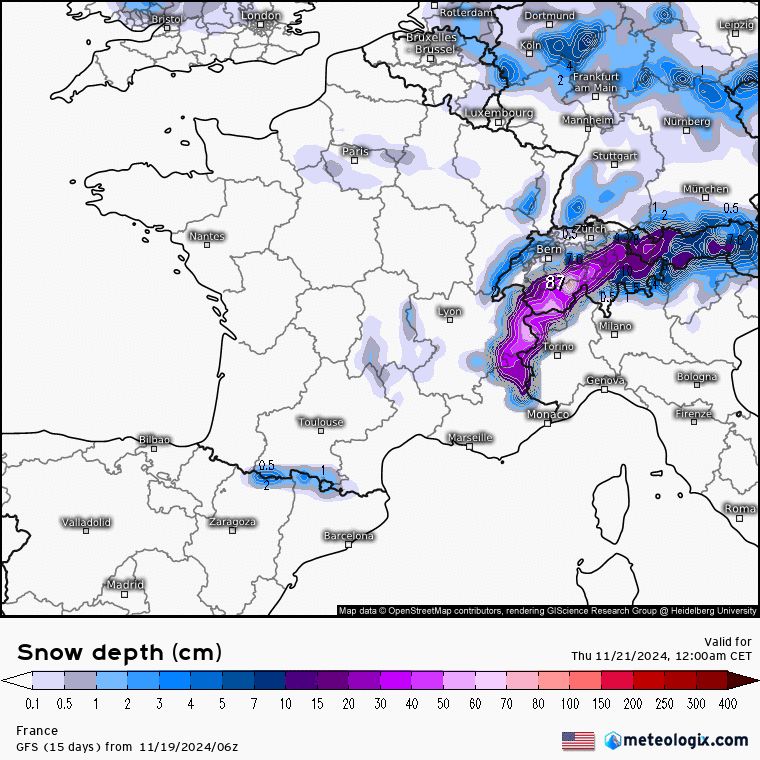
The Swiss-MRF model anticipates snow further south.
Warm weather for the weekend, the snow is moving away
Friday, on the other hand, will act as a turning point, with a morning still very cold, of course, but a snowy trend that is moving away. “A few snowfalls are still possible in the north of France, but the depression is going away and the mildness is returning,” summarizes Guillaume Séchet at actu.fr.
Like Yann Amice, he plans a “warm spell” this weekend of November 23 and 24, 2024due to a “powerful southerly current” which will suddenly raise temperatures. “We are going to get 8 to 10°C more in 24 hours,” he estimates.
But let's keep our sweaters and hats close: “a large western half of France could experience quite a bit of wind and strong gusts,” adds Yann Amice. Beforeanother hectic and wet week.
Follow all the news from your favorite cities and media by subscribing to Mon Actu.

