We are living the last hours under the influence of high pressure. Indeed, a lasting change in weather will take place across the country. The anticyclone will remain clearly behind between Portugal and the Azores, giving way to depressions which will follow one another over a good part of Europe. These depressions will come from the north of the Atlantic basin in a northwesterly flow. This is why we talk about maritime polar. What will be the consequences for our region? That's what we're going to have here.
The first disturbance will approach France from the North and then head towards the southern half on Tuesday. After a slightly cloudy Monday, we can expect a more unsettled day on Tuesday. However, in this type of flow, our reliefs (Cévennes, Larzac, Espinouse) block part of the degradation which occurs more attenuated on our plains. We have illustrated this situation below:
Map: Weather sky
As we can see, the two departments which will be most affected by the sequence of disturbances will be Lozère and Aveyron. The coastal departments will have the remainder with cloudy periods and a few showers but the precipitation will be much more scattered than on the northwest slopes of our reliefs.
A second potentially more dynamic depression is possible between Thursday and Friday. It could quickly widen across the Atlantic to affect our country in its full potential. A gale, rain and temporary snow at low altitudes are likely as it passes. As is often the case, our region will be on the fringes of the main activity. However, this does not exclude a good gust of wind and a disturbed passage. Regarding the snow, you won't have to wait for it in Lozère.
Map: Weather sky
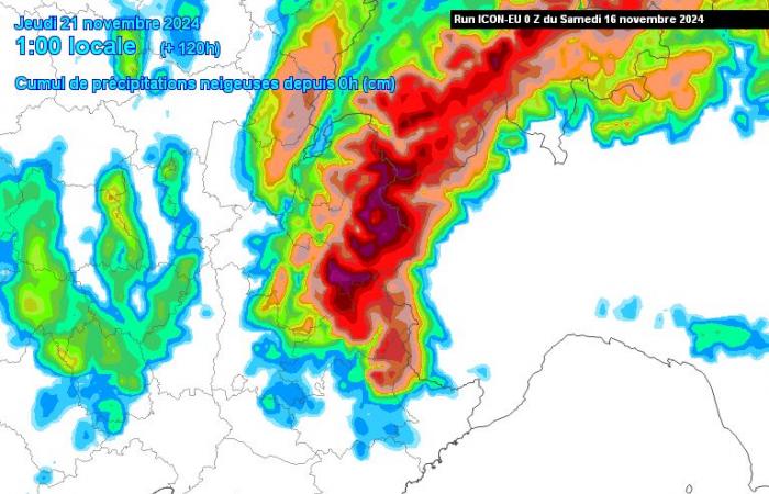
Example below with snow modeling forecast by Thursday. We notice that Lozère could experience its first real snowy episode of the season. Nothing extraordinary for the end of November. We are well aware of this, this change in weather will not be exceptional. It is even more normal than an anticyclonic ridge situation like we have had regularly since the beginning of the month.
No cold snap in sight but only the beginnings of the arrival of winter, logical in this season. Furthermore, this may not last because the scenarios model depressions which will tend to deepen more and more towards the South. This could bring us a humid but gentler southerly flow. This nevertheless remains to be confirmed because the situation will partly depend on the circulation of the first depressions expected at the start of next week.
Facebook
Twitter
Google+
France


