In France, 17.1 million inhabitants are regularly exposed to risks of flooding by overflowing rivers. This is how the French State, through the Vigicrues reference information service, which allows you to know the situation of the main rivers, provides all audiences with tools, both individuals and professionals, a set of tools to warn the population in the event of flood risk and crisis managers so that they can mobilize the necessary means of rescue.
Among these tools, there is a “raw” vigilance card updated twice a day, information bulletins, real -time data and forecasts, the Vigicrues flash information service specific to sudden floods of small rivers, the national collaborative platform of flood benchmarks and hydroportail, which gives access to data from watercourses in France.
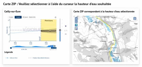
In a desire to further improve prevention towards floods, the cards of potential flood zones (ZIP) are now accessible on the website and the Vigicrues mobile application via a dynamic map. This new feature allows an interactive and more intuitive visualization of flooding cards. The mapping of the zip describes the potential extent of a flood on a given territory through the display of the geographic grip and the different potential water depths within the grip).
34,000 km of rivers covered by Vigicrues Flash
The authorities and residents exposed to this risk can then view the impacts expected in the territory (people, goods and activities), depending on the height of water at a given station. ZIP maps are a tool available to everyone, and in particular public authorities to take the necessary measures to protect populations.
« With this new vigicrues feature, the State strengthens its capacity to anticipate floods and protect the population. I salute, on this occasion, the work undertaken by the Vigicrues teams to provide everyone with clearer, more accessible and more dynamic information to allow French to act knowing the risk of flooding “Indicates Agnès Pannier-Runacher, Minister of Ecological Transition, Biodiversity, Forest, Sea and Fisheries.
Recall that the Vigicrues system informs about the risks of floods in the next 24 hours of the 23,000 km of large rivers in France. On smaller rivers not covered by “raw” alert, subject to sudden variations and, therefore, difficult to anticipate, the complementary vigicrues flash service signals, in real time, a risk of sudden floods, qualified as strong or very strong, in the coming hours.
With the addition of more than 100 municipalities, in Ardèche, Aveyron, Creuse, Essonne and Yvelines, Vigicrues Flash now covers more than 11,400 municipalities and 34,000 km of watercourses. This automatic SMS alert system – a free subscription service reserved for institutional players (prefectures, town halls, inter -municipalities and network operators) – is also associated with the APIC service (Intense rainy warning on the scale of the municipalities) of Météo France.


